geo.wikisort.org - Mountains
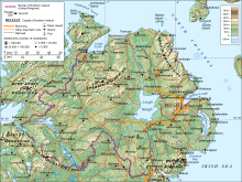
This is a list of the six traditional counties of Northern Ireland by their highest point.[1][2][3][4]
| Rank | County | Height (m) | Relative height | Name | Grid reference | |
|---|---|---|---|---|---|---|
| 1 | Down | 850 | 822 | Slieve Donard | J357277 | |
| 2–3 | Londonderry and Tyrone | 678 | 657 | Sawel | H618973 | |
| 4 | Fermanagh | 665 | 570 | Cuilcagh | H123281 | |
| 5 | Armagh | 573 | 478 | Slieve Gullion | J025203 | |
| 6 | Antrim | 550 | 515 | Trostan | D179236 | |

See also
- List of Irish counties by highest point
- List of counties of England and Wales in 1964 by highest point
- List of ceremonial counties of England by highest point
- List of mountains and hills of the United Kingdom
- List of Scottish council areas by highest point
- List of Scottish counties by highest point
- List of Welsh principal areas by highest point
- List of Northern Ireland districts by highest point
References
- "Northern Ireland's County High Points - Northern Ireland's Outdoor Adventure Blog". www.outdoorni.com.
- Gribbon, Kieron (5 March 2012). Ireland's County High Points. Gill & Macmillan Ltd. ISBN 9781848899629 – via Google Books.
- "Highest Mountains In Northern Ireland". WorldAtlas.
- Muir, Jonny (15 January 2014). The UK's County Tops: Reaching the top of 91 historic counties. Cicerone Press Limited. ISBN 9781849659635 – via Google Books.
| British Isles |  | |
|---|---|---|
| Scotland | ||
| Outside Scotland | ||
| England | ||
| Ireland | ||
| County tops |
| |
Текст в блоке "Читать" взят с сайта "Википедия" и доступен по лицензии Creative Commons Attribution-ShareAlike; в отдельных случаях могут действовать дополнительные условия.
Другой контент может иметь иную лицензию. Перед использованием материалов сайта WikiSort.org внимательно изучите правила лицензирования конкретных элементов наполнения сайта.
Другой контент может иметь иную лицензию. Перед использованием материалов сайта WikiSort.org внимательно изучите правила лицензирования конкретных элементов наполнения сайта.
2019-2026
WikiSort.org - проект по пересортировке и дополнению контента Википедии
WikiSort.org - проект по пересортировке и дополнению контента Википедии