geo.wikisort.org - Mountains
Ben More Assynt (Scottish Gaelic: Beinn Mhòr Asaint) is a mountain in Assynt in the far north-west of Scotland, 30 kilometres (19 miles) north-northeast of Ullapool. The name translates as "big mountain of Assynt", and with a height of 998 metres (3,274 feet) it is the highest point in Sutherland.
| Ben More Assynt | |
|---|---|
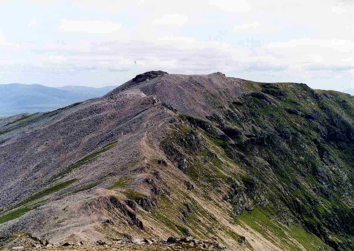 Ben More Assynt from Conival. | |
| Highest point | |
| Elevation | 998 m (3,274 ft)[1] |
| Prominence | 835 m (2,740 ft)Ranked 26th in British Isles |
| Parent peak | Sgurr Mor |
| Listing | Munro, Marilyn, County top (Sutherland) |
| Coordinates | 58°08′17″N 4°51′29″W |
| Naming | |
| English translation | Big mountain of Assynt |
| Language of name | Gaelic |
| Pronunciation | Scottish Gaelic: [peɲ ˈvoːɾ ˈas̪ɪɲtʲ] |
| Geography | |
 Ben More Assynt Assynt, Scotland | |
| Parent range | Northwest Highlands |
| OS grid | NC317201 |
| Topo map | OS Landranger 15, OS Explorer 442 |
The mountain lies in the east of Assynt, set apart from the area's better known and more dramatic (but lower) mountains such as Suilven. It is hidden from the traveller on the A837 road by the adjacent Munro of Conival, and the best views of it are obtained from nearby summits. The higher slopes of the mountain are capped by light coloured quartzite boulders, giving it a distinctive appearance.
Over 90 km2 (35 sq mi) of land around Ben More Assynt have been declared a Site of Special Scientific Interest (SSSI) because of their geological interest and rare plant species.
Geography
Ben More Assynt is situated on a ridge of high ground which runs roughly north to south on the east side of the A837 road near Inchnadamph. This ridge forms part of the main north–south watershed of Scotland, with drainage from the mountain reaching the North Sea and the Atlantic Ocean on opposite sides of mainland Scotland. The mountain's eastern and southern slopes are drained by the River Oykel and its tributary, the River Cassley, which flow into the Dornoch Firth on Scotland's east coast. The River Traligill drains the western flanks through Loch Assynt to reach the Atlantic at Lochinver.
The mountain is connected to the neighbouring peak of Conival to the west by a lofty ridge with a low point of 880 m (2,890 ft). Since Conival lies in the way of the ascent from Inchnadamph, the two are almost invariably ascended together. Ben More Assynt also has a subsidiary "top" listed in Munro's Tables, called simply the South Top; situated one kilometre south of the summit, it is 960 m (3,150 ft) high.
Geology
The Assynt area lies within the Moine Thrust Belt and is a classic locality in the history of the development of theories about thrust tectonics.[2] The mountains of Ben More Assynt and Conival sit on the Ben More thrust sheet which is bounded by the Ben More Thrust below and the Moine Thrust above. The thrust sheet consists of Lewisian gneiss with a cover of Torridonian sandstones and Cambrian quartzite. Lewisian gneisses are exposed to the south and southeast of the peak of Ben More Assynt and forms the ridge to the South Top, making it the highest located example of this rock type. The peak itself consists of Cambrian quartzite, which also forms the ridge to Conival and the ground to the north and northeast of the peak. Torridonian sediments are only exposed around Conival.[3]
Ascents
An ascent of Ben More Assynt is usually combined with the neighbouring Munro of Conival, which if starting from the hamlet of Inchnadamph (grid reference NC250218), is climbed first. From Inchnadamph the route of ascent follows the River Traligill to its source on the col between Conival and Beinn an Fhurain at a height of 750 m (2,460 ft). It is then a stiff climb over shattered quartzite to reach Conival’s highest point. Ben More Assynt’s summit lies 1.5 km (1 mi) east and is a demanding walk over quartzite stones and scree, even though there is only just over 100 metres of re-ascent. The summit is marked by a shattered lump of quartzite. The sharp arête is quite tricky to negotiate in places; according to Ralph Storer, it "has been flatteringly compared to the Aonach Eagach, with several unexpectedly awkward moves across exposed slabs requiring care (especially when wet)".[4]
Wildlife and conservation
Ben More Assynt is home to many threatened species of vegetation. There are four species of plants which are on the World Conservation Union’s (IUCN) Red List of Threatened Species, and there are 27 nationally scarce varieties of plants within the Site of Special Scientific Interest.
In 2005 and 2006 the firm Airtricity proposed to build a 25-turbine wind farm at Invercassly, 22 km (13+1⁄2 mi) southeast of the mountain. Protesters used Ben More Assynt in their arguments against the project, saying that the wind farm would have a detrimental effect on the view from the mountain and the sense of wilderness would be greatly reduced. The future of the proposal is still in discussion.
New Memorial
In April 1941, during the Second World War, all 6 of the crew on board an Avro Anson were killed when the aircraft crashed on Ben More Assynt. Due to the inaccessibility of the crash site, the crew were buried on the mountain; their final resting places marked with a cairn.
In 2012, the Commonwealth War Graves Commission decided to replace the existing cairn, which had deteriorated in the harsh climate, with a 600-kilogramme granite marker to identify and protect the burial site. At an elevation of around 600 m (2,000 ft), the burial site on Ben More Assynt is one of the Commission’s most remote grave sites in the UK and the logistics of replacing the cairn have proved challenging. In the end, a Chinook helicopter from RAF Odiham had to be used to carry the granite memorial to the burial site. The granite memorial now marks the spot where Pilot Officer William Drew, Sergeant Jack Emery, Sergeant Harold Arthur Tompsett, Flying Officer James Henry Steyn, Sergeant Charles McPherson Mitchell and Flight Sergeant Thomas Brendon Kenny lost their lives when their aircraft crashed.
Gallery
 Ben More Assynt from Conival.
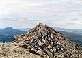 The shattered quartzite summit of Ben More Assynt.

References
- "walkhighlands Ben More Assynt". walkhighlands.co.uk. 2014. Retrieved 1 March 2014.
- "Knockan Crag". Scottish Geology. Hunterian Museum. Archived from the original on 16 June 2006. Retrieved 5 December 2011.
- Krabbendam, M.; Leslie G. (2004). "Lateral ramps and thrust terminations: an example from the Moine Thrust Zone, NW Scotland" (PDF). Journal of the Geological Society. London: Geological Society. 161: 551–554. doi:10.1144/0016-764904-015. Retrieved 5 December 2011.
- "100 Best Routes On Scottish Mountains", Ralph Storer, ISBN 0-7515-0300-2, Gives this quote.
- The High Mountains of Britain and Ireland, Irvine Butterfield, ISBN 0-906371-30-9
- The Munros (SMC Guide), Donald Bennet et al., ISBN 0-907521-13-4
- 100 Best Routes on Scottish Mountains, Ralph Storer, ISBN 0-7515-0300-2
- Hamish’s Mountain Walk, Hamish Brown, ISBN 1-898573-08-5
- University of Leeds page on Assynt Geology
- Airtricity page on Invercassley wind farm
- Scotland Natural Heritage page on SSSI
- Highland Council report on wind farm
Munros of Scotland: Loch Carron to Loch Maree | |||
|---|---|---|---|
 |  | ||
List of Munros | |||
Most prominent mountains of Britain and Ireland (the P600s) | ||
|---|---|---|
| Northern Highlands (20) |    | |
| Western Highlands (20) | ||
| Central and Eastern Highlands (13) | ||
| Southern Highlands (15) |
| |
| Islands (13) | ||
| Scottish Lowlands, England and Wales (13) | ||
| Republic of Ireland, Northern Ireland (25) | ||
На других языках
[de] Ben More Assynt
Der Ben More Assynt ist ein 998 m (3.274 ft) hoher Berg in den schottischen Highlands. Auf Gälisch lautet sein Name Beinn Mhòr Asaint, er bedeutet Großer Berg von Assynt.[1] Er ist der höchste Berg in Assynt, einer Landschaft in den Northwest Highlands und zugleich in der Grafschaft Sutherland. Der Ben More Assynt und der benachbarte Conival sind die einzigen als Munro eingestuften Berge in Assynt. Beide Berge sind Teil einer entlang der Hauptwasserscheide zwischen Nordsee und Schottischer See von Nord nach Süd durch Sutherland laufenden Bergkette und deren höchste Punkte. Während der Conival im Verlauf der Nord-Süd-Kette liegt, ist der Ben More Assynt etwas östlich davon vorgelagert. Er besitzt zwei Gipfel, neben dem 998 m hohen Hauptgipfel den 960 m hohen Südgipfel. Beide sind durch einen felsigen und ausgesetzten Grat verbunden.- [en] Ben More Assynt
[es] Ben More Assynt
Ben More Assynt (en gaélico escocés Beinn Mhòr Asaint pronunciado [peiɲ voːɾ ˈas̪əɲtʲ]) es una montaña en Assynt en el extremo noroeste de Escocia (Reino Unido), a 30 kilómetros NNW de Ullapool. El nombre quiere decir "la gran montaña de Assynt", y con una altura de 998 metros es el punto más alto del condado de Sutherland.[it] Ben More Assynt
Ben More Assynt (Beinn Mhòr Asaint in gaelico scozzese) è una montagna situata nell'estremo nord-ovest della Scozia, nella zona di Assynt.Другой контент может иметь иную лицензию. Перед использованием материалов сайта WikiSort.org внимательно изучите правила лицензирования конкретных элементов наполнения сайта.
WikiSort.org - проект по пересортировке и дополнению контента Википедии