geo.wikisort.org - Mountains
Liathach (pronounced [ˈʎiəhəx], Scottish Gaelic for 'the hoary place')[2] is a mountain in the Torridon Hills, in the Northwest Highlands of Scotland. It stands between Loch Torridon and the neighbouring mountain Beinn Eighe. The mountain is a ridge running east–west, with several peaks, and its upper half is made up of many steep rocky terraces. The highest peak is the Munro of Spidean a' Choire Lèith ('peak of the grey corrie') at 1,055 metres (3,461 ft) high. The other Munro peak is Mullach an Rathain at 1,024 metres (3,360 ft) high.
| Liathach | |
|---|---|
 Liathach from the east | |
| Highest point | |
| Elevation | 1,055 m (3,461 ft)[1] |
| Prominence | 957 m (3,140 ft) Ranked 8th in British Isles |
| Parent peak | Càrn Eige |
| Listing | Marilyn, Munro |
| Naming | |
| English translation | the hoary place |
| Language of name | Gaelic |
| Pronunciation | Scottish Gaelic: [ˈs̪pitʲan ə ˈxɔɾʲə ˈʎeː] |
| Geography | |
| Location | Torridon, Scotland |
| Parent range | Northwest Highlands |
| OS grid | NG929579 |
| Topo map | OS Landranger 25 |
Geology
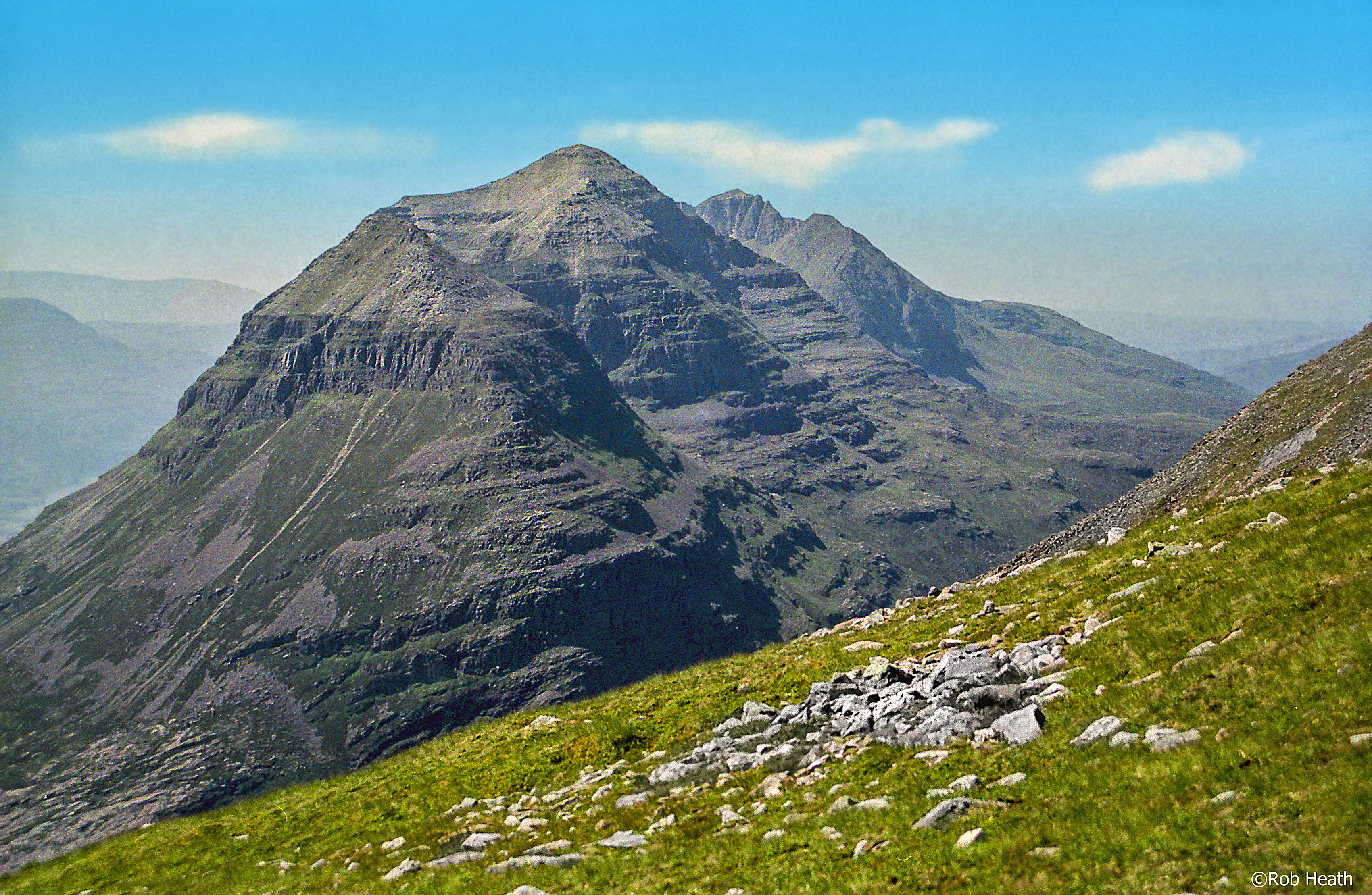
The mountain is composed of Torridonian sandstone which forms massive near-horizontal strata. They form the numerous terraces that are obvious from afar. The rocks are mainly red and chocolate sandstones, arkoses, flagstones and shales with coarse conglomerates locally at the base. Some of the materials of these rocks were derived from the underlying Lewisian gneiss, upon the uneven surface of which they rest, but the bulk of the material was obtained from rocks that are nowhere now exposed. Upon this ancient denuded land surface the Torridonian strata rest horizontally or with gentle inclination. Some of the peaks, such as Beinn Eighe, are capped with white quartzite, giving them a distinctive appearance when seen from afar. Some of the quartzite contains fossilized worm burrows and is known as pipe rock. It is about 500 million years old. The Torridon landscape is itself highly denuded by glacial and alluvial action, and represents the remnants of an ancient peneplain.
Climbing
| Listed summits of Liathach | ||||
| Name | Grid ref | Height | Status | |
|---|---|---|---|---|
| Mullach an Rathain | NG912577 | 1023.8 m (3,359 ft) | Marilyn, Munro | |
| Meall Dearg | NG913579 | 955 m (3133 ft) | Munro Top | |
| Stob a' Choire Liath Mhòr | NG932581 | 983 m (3225 ft) | Munro Top | |
| Am Fasarinen | NG923574 | 927 m (3041 ft) | Munro Top | |
| Stùc a' Choire Dhuibh Bhig | NG942582 | 915 m (3002 ft) | Munro Top | |
Liathach has four listed "Tops" in the Munro Tables, Meall Dearg at 3133 feet (955 m) stands off the main ridge at the end of the Northern Pinnacles which run north from Mullach an Rathain. The route along the Northern Pinnacles is considered a rock climb, although another route to the top from Coire na Caime only involves a short steep scramble on the final 50m to gain the ridge. Irvine Butterfield considers Meall Dearg "The most difficult top in the British Isles challenged only by the Inaccessible Pinnacle of Sgùrr Dearg".[3][4] The Northern Pinnacles were first climbed in 1894 by Hinxman, Rennie and Douglas.[5]
Climbing the mountain including both of the above peaks is a challenging expedition; the intervening ridge is for the most part a series of rocky pinnacles known as Am Fasarinen (The Teeth), which reaches a height of 927 metres at the western end and is considered a Munro "top". There are few places on the ridge for descent, so once committed, the walker has little choice but to complete the entire ridge walk. The pinnacles can however be avoided by means of a narrow path that traverses the ridge on the south side. The path is very exposed, and there is much erosion at points where it crosses any of a series of gullies. In winter the traverse of Liathach becomes an even more serious expedition.
In popular culture
Scottish singer Jo Hamilton named a song after Liathach on her debut album Gown.[6] The song was subsequently covered by Prince on his 2013 Live Out Loud tour.[7]
References
- The Munros and Tops, Chris Townsend, ISBN 1-84018-727-1
- The High Mountains of Britain and Ireland, Irvine Butterfield, ISBN 0-906371-30-9
Footnotes
- "Liathach". Hill Bagging - the online version of the Database of British and Irish Hills (DoBIH). 2019. Retrieved 19 June 2019.
- "Liathach". Ainmean-Àite na h-Alba: Gaelic Place-Names of Scotland.
- "The Munros and Tops" Page 174 Gives details of Meall Dearg.
- "The High Mountains of Britain and Ireland" Page 223 Gives quote from Butterfield and route from Coire na Caime.
- Douglas, W. (1894). "The Northern pinnacles of Leagach". Scottish Mountaineering Club Journal. 3.
- "'Liathach' - official video". Archived from the original on 21 December 2021.
- "Live Out Loud tour setlist".
External links
- Liathach is at coordinates 57.564329°N 5.462121°W
Most prominent mountains of Britain and Ireland (the P600s) | ||
|---|---|---|
| Northern Highlands (20) |    | |
| Western Highlands (20) | ||
| Central and Eastern Highlands (13) | ||
| Southern Highlands (15) |
| |
| Islands (13) | ||
| Scottish Lowlands, England and Wales (13) | ||
| Republic of Ireland, Northern Ireland (25) | ||
Munros of Scotland: Loch Carron to Loch Maree | |||
|---|---|---|---|
 |
|  | |
List of Munros | |||
На других языках
[de] Liathach
Der Liathach (Der Graue auf Gälisch) ist ein 1055 Meter hohes Bergmassiv in Schottland. Er liegt an der Westküste nordöstlich der Ortschaft Torridon in den Torridon Hills in den Northwest Highlands, die zur Council Area Highland gehören. Zwei der Gipfel des Liathach, der Spidean a’ Choire Lèith mit 1055 Metern Höhe am östlichen Ende des Massivs und der 1023 Meter hohe Mullach an Rathain am westlichen Ende sind als Munro und als Marilyn eingestuft. Östlich des Liathach liegt das Bergmassiv des Beinn Eighe, westlich schließt sich der Beinn Alligin an.- [en] Liathach
[fr] Liathach
Le Liathach est une montagne du Royaume-Uni située en Écosse, dans les Torridon Hills qui font partie des Highlands. Elle culmine au Spidean a' Choire Lèith à 1 055 mètres d'altitude, l'un des nombreux sommets de cette montagne allongée dans le sens est-ouest.Другой контент может иметь иную лицензию. Перед использованием материалов сайта WikiSort.org внимательно изучите правила лицензирования конкретных элементов наполнения сайта.
WikiSort.org - проект по пересортировке и дополнению контента Википедии