geo.wikisort.org - Mountains
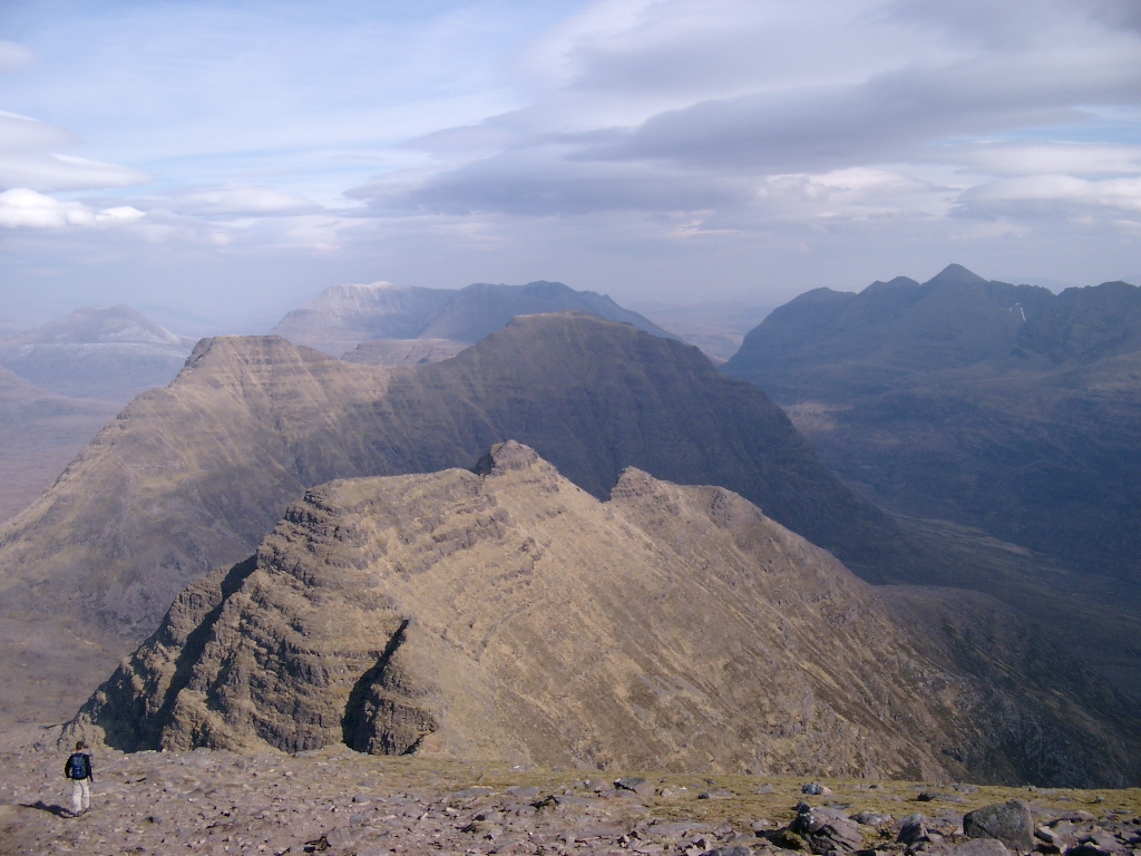
Beinn Alligin (Scottish Gaelic: Beinn Àilleagan) is one of the classic mountains of the Torridon region of Scotland, lying to the north of Loch Torridon, in the Highlands. The name Beinn Alligin is from the Scottish Gaelic, meaning Jewelled Hill. The mountain has two peaks of Munro status: Tom na Gruagaich (922 metres (3,025 ft)) to the south, and Sgùrr Mhòr at 986 metres (3,235 ft) to the north.[2]
| Beinn Alligin | |
|---|---|
| Sgùrr Mhor | |
 Beinn Alligin | |
| Highest point | |
| Elevation | 986 m (3,235 ft)[1] |
| Prominence | c. 601 m |
| Parent peak | Beinn Eighe |
| Listing | Munro, Marilyn |
| Naming | |
| Native name | Beinn Àilleagan (Scottish Gaelic) |
| English translation | Big Peak |
| Pronunciation | English: /ˌbeɪn ˈælɪɡɪn/ bayn AL-ig-in Scottish Gaelic: [peɲ ˈaːʎakən] |
| Geography | |
 Beinn Alligin Torridon, Scotland | |
| OS grid | NG865613 |
| Topo map | OS Landranger 19, 24 |
| Listed summits of Beinn Alligin | ||||
| Name | Grid ref | Height | Status | |
|---|---|---|---|---|
| Sgùrr Mhòr | NG865686 | 986 m (3,235 ft) | Munro, Marilyn | |
| Tom na Gruagaich | NG859601 | 922 m (3,025 ft) | Munro, Marilyn | |
| Na Rathanan | NG873613 | 866 m (2,841 ft) | Corbett Top | |
One of the most prominent features of Beinn Alligin is a great cleft known as Eag Dhubh na h-Eigheachd (black gash of the wailing) or Leum na Caillich, which cuts into the ridge south of the summit. It is the scar of the most spectacular rockslide or rock avalanche in Britain, which runs out into the corrie of Toll a' Mhadaidh Mor. It occurred around 3750 years ago and is around 3.5 million cubic metres in volume.[3] According to local folklore shepherds on the mountain would hear cries from the gash; those who investigated the source of these cries would inevitably fall to their deaths.[4]
Beinn Alligin lies on the National Trust for Scotland's Torridon Estate,[5] which has been owned by the charity since 1967,[6] and forms part of both a Site of Special Scientific Interest (SSSI) and a Special Area of Conservation (SAC).[7][8]
Ascent
The usual route of ascent starts from the minor road between Torridon village and Inveralligin, following the route of the Abhainn Coire Mhic Nobuil (a river), before heading up into the corrie of Coir nan Laogh. Steep grassy slopes then lead to the summit of Tom na Gruagaich. The main ridge of Beinn Alligin is then followed round to the north, leading the hillwalker towards Sgùrr Mhòr. Below the summit of this peak is a deep gash in the hillside known as Eag Dubh, the black notch, one of Beinn Alligin's most recognisable features.
From the summit of Sgùrr Mhòr, it is possible to continue along the ridge, now heading in an easterly direction. The ridge at this point becomes much rockier, and a series of pinnacles known as the "Horns of Alligin" (Scottish Gaelic: Na Rathanan) must be negotiated. The horns provide good summer scrambling for those with a head for heights, but in winter they are a much more serious proposition.
An alternative descent, avoiding the horns, can be made by leaving the Beinn Alligin ridge at the bealach between the two summits, from where grassy slopes can be followed westwards down into a neighbouring glen. This route is not straightforward under winter conditions.
External links
- Computer-generated virtual panoramas Beinn Alligin Index
References
- "Beinn Alligin". Hill Bagging - the online version of the Database of British and Irish Hills (DoBIH). 2019. Retrieved 19 June 2019.
- Donald Bennet & Rab Anderson, ed. (2016). The Munros: Scottish Mountaineering Club Hillwalkers' Guide. Scottish Mountaineering Trust. pp. 212–213. ISBN 9780907521945.
- Ballantyne CK (2007) in Mass Movements of Great Britain, ed. RG Cooper, JNCC, 111-116.
- Ian Mitchell (2004). Scotland's Mountains Before the Mountaineers. Luath Press. p. 136. ISBN 0946487391.
- Ordnance Survey. 1:50000 Landranger map. Sheet 24, Raasay & Applecross.
- National Trust for Scotland. 2020 Guide. Page 109.
- "Torridon Forest SSSI". Scottish Natural Heritage. Retrieved 17 July 2020.
- "Loch Maree Complex SAC". Scottish Natural Heritage. Retrieved 17 July 2020.
Munros of Scotland: Loch Carron to Loch Maree | |||
|---|---|---|---|
 |
|  | |
List of Munros | |||
Most prominent mountains of Britain and Ireland (the P600s) | ||
|---|---|---|
| Northern Highlands (20) |    | |
| Western Highlands (20) | ||
| Central and Eastern Highlands (13) | ||
| Southern Highlands (15) |
| |
| Islands (13) | ||
| Scottish Lowlands, England and Wales (13) | ||
| Republic of Ireland, Northern Ireland (25) | ||
На других языках
[de] Beinn Alligin
Der Beinn Alligin (Gälisch für Berg der Schönheit oder Edelsteingeschmückter Berg) ist ein bis zu 986 Meter hohes Bergmassiv in den schottischen Highlands. Er liegt nordwestlich von Torridon in den Torridon Hills in der Council Area Highland an der schottischen Westküste. Zwei der Gipfel des Beinn Alligin, der Tom na Gruagaich mit 922 Meter Höhe am südlichen Ende des Massivs und der 986 Meter hohe, in der Mitte des Massivs liegende Sgùrr Mhòr sind als Munro eingestuft, der Tom na Gruagaich allerdings erst seit 1997.[1]- [en] Beinn Alligin
Другой контент может иметь иную лицензию. Перед использованием материалов сайта WikiSort.org внимательно изучите правила лицензирования конкретных элементов наполнения сайта.
WikiSort.org - проект по пересортировке и дополнению контента Википедии