geo.wikisort.org - Mountains
Ben Chonzie or Ben-y-Hone[2][3] (Scottish Gaelic: Beinn a' Chomhainn,[3] 'mountain of the narrowness',[4] or possibly from Beinn Chòinnich, 'mossy mountain')[4] is a mountain in the Breadalbane region of the Scottish Highlands. It is eleven kilometres northwest of Crieff. It stands at 931 metres (3,054 ft) and is therefore listed as a Munro.[5] It is the highest point of a large area of moorland and rounded hills between Loch Earn and Loch Tay, and with a broad, flat summit and relatively few distinguishing features, it is often regarded as one of Scotland's least interesting Munros.[6]
| Ben Chonzie (Ben-y-Hone) | |
|---|---|
| Beinn a' Chomhainn | |
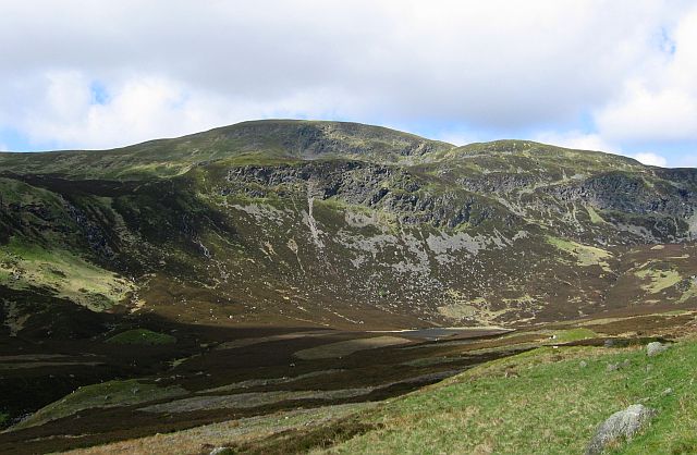 Ben Chonzie from the Glen Turret side | |
| Highest point | |
| Elevation | 931 m (3,054 ft)[1] |
| Prominence | 645 m (2,116 ft) |
| Parent peak | Ben More |
| Listing | Munro, Marilyn |
| Coordinates | 56°27′14″N 3°59′31″W |
| Naming | |
| Language of name | Gaelic |
| Pronunciation | Gaelic [ˈpeiɲ ə ˈxɔːɲɪç] ( |
| Geography | |
| Location | Perth and Kinross, Scotland |
| Parent range | Grampian Mountains |
| OS grid | NN773308 |
| Topo map | OS Landranger 51 and 52 OS Explorer 379 |
It is most often climbed from Invergeldie (Comrie) to the southwest; however it can also be climbed from the southeast by way of Glen Turret. The latter is longer but presents walkers with a more interesting and scenic climb, having an array of buttresses and cliffs which can be tackled by those who feel brave, or passed by on either side.[7] Mountain hares (Lepus timidus, subspecies Lepus timidus scoticus) can be seen around the plateau area if walkers are quiet and observant. There are also many other animals on the approaches to the Ben, including Buzzards, other birds of prey, and frogs and newts in the pools alongside the landrover track that runs up the eastern aspect of the loch. Deer may be seen on the slopes to the north of the Ben.
References
- "walkhighlands Ben Chonzie". walkhighlands.co.uk. 2013. Retrieved 15 October 2013.
- On Ben Chonzie, real hillwalkers don't picnic, Robin Howie, The Scotsman, 19 November 2005
- "Ben Chonzie/Ben-y-Hone". Ainmean-Àite na h-Alba: Gaelic Place-Names of Scotland.
- Drummond, Peter (1991). Scottish Hill and Mountain Names. Scottish Mountaineering Trust, p.167. ISBN 0-907521-30-4
- The Munros (SMC Guide), Donald Bennett et al., ISBN 0-907521-13-4
- "...having a reputation of being one of the dullest Munros in the land" The Munros: Scotland's Highest Mountains, Cameron McNeish, ISBN 0-947782-50-8
- The Southern Highlands (SMC Guide), Donald Bennett et al., ISBN 0-907521-34-7
 |
|  | |
List of Munros | |||
Most prominent mountains of Britain and Ireland (the P600s) | ||
|---|---|---|
| Northern Highlands (20) |    | |
| Western Highlands (20) | ||
| Central and Eastern Highlands (13) | ||
| Southern Highlands (15) |
| |
| Islands (13) | ||
| Scottish Lowlands, England and Wales (13) | ||
| Republic of Ireland, Northern Ireland (25) | ||
This article about a Site of Special Scientific Interest in Scotland is a stub. You can help Wikipedia by expanding it. |
This Perth and Kinross location article is a stub. You can help Wikipedia by expanding it. |
На других языках
[de] Ben Chonzie
Der Ben Chonzie (schottisch-gälisch Beinn a’ Chóinnich, „Kuppe des Mooses“) ist ein 931 m (3.054 ft) hoher Berg in der Council Area Perth and Kinross in Schottland. Er zählt zu den Munros und liegt in der weitläufigen Moor- und Heidelandschaft zwischen Crieff und Loch Tay, deren höchsten Punkt er darstellt. Im Unterschied zu vielen anderen Munros besitzt der Ben Chonzie keinen ausgeprägten Gipfel, sein höchster Punkt befindet sich auf einem weitläufigen grasigen Plateau und wird lediglich durch einen größeren Cairn markiert. Lediglich nach Osten hin befinden sich ein paar steilere Felsabbrüche. Auch die Anstiege aus den benachbarten Tälern Glen Turret und Glen Lednock verlangen keine besonderen Anstrengungen. Der Ben Chonzie wird daher öfters als „langweiligster Munro“ bewertet.[1] Bekannt sind der Berg und die umliegenden Täler für einen großen Bestand an Schneehasen.[2]- [en] Ben Chonzie
Другой контент может иметь иную лицензию. Перед использованием материалов сайта WikiSort.org внимательно изучите правила лицензирования конкретных элементов наполнения сайта.
WikiSort.org - проект по пересортировке и дополнению контента Википедии