geo.wikisort.org - Mountains
Ben Vane (Scottish Gaelic: Beinn Mheadhain)[2] is a mountain in the Arrochar Alps of Argyll, in the Southern Highlands of Scotland. It reaches 915 metres (3,002 ft), making it a Munro. It lies between Beinn Ìme and Ben Vorlich.
| Ben Vane | |
|---|---|
| Scottish Gaelic: Beinn Mheadhain | |
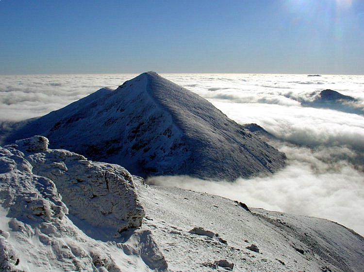
 Ben Vane seen from Ben Vorlich | |
| Highest point | |
| Elevation | 915 m (3,002 ft)[1] |
| Prominence | 423 m (1,388 ft) |
| Parent peak | Beinn Ìme |
| Listing | Munro, Marilyn |
| Coordinates | 56°14′59″N 4°46′54″W |
| Naming | |
| English translation | middle mountain |
| Language of name | Gaelic |
| Pronunciation | Gaelic [ə ˈveiɲ ˈviə.ɛɲ] ( |
| Geography | |
| Location | Arrochar Alps, Argyll, Scotland |
| Parent range | Grampian Mountains |
| OS grid | NN277098 |
| Topo map | OS Landranger 56 OS Explorer 364 |

Landscape
The underlying geology almost entirely comprises the Beinn Bheula Schist Formation - psammite and pelite with a Siluro-Devonian dyke prominent round the northern and eastern face.[3] It is one of the Arrochar Alps and stands slightly separate from the other mountains of the group being connected on its western side to the neighbouring Beinn Ìme by a low col at 492 metres. Ben Vane is characterised by steep and rugged slopes which fall away to the Inveruglas Water to the east and the Allt Coiregroigan to the south; to the north the descent is more undulating going over the subsidiary top of Beinn Dubh before falling to the valley at the north end of Loch Sloy. Dense forestry cloak the mountain on its lower southern slope in Allt Coiregroigan. Also on these southern slopes by the Allt Coiregroigan is a disused quarry which provided crushed stone used for the construction of the Loch Sloy dam in the late 1940s. The dam wall lies two km to the north of the quarry and a conveyor belt was constructed to carry the crushed stone over the lower slopes of Ben Vane to the batching plant beside the dam.[4]
Climbing
The direct route up the mountain starts from the paid car park at grid reference NN322098 opposite the Loch Sloy power station on the banks of Loch Lomond and follows the private tarmac road by the Inveruglas Water up to the Loch Sloy hydro dam for two kilometres before striking steeply up the mountain's eastern ridge. Initially there is some boggy ground and some crags to avoid higher up but the top is easily reached after a few false summits on the way. Ben Vane can also be climbed in conjunction with some of the other Arrochar Alps, especially Beinn Ìme and Beinn Narnain.[5]
The summit of the mountain is a small plateau crowned by a cairn. The highlights of the view from the top of Ben Vane are Ben Vorlich and Loch Sloy to the northeast and the rest of the Arrochar Alps to the southwest. A' Chrois looks especially fine across the deep glen of Allt Coiregrogain. The vista to Lochs Arklet and Katrine to the east is very good.

References
- "walkhighlands Ben Vane". walkhighlands.co.uk. 2013. Retrieved 16 October 2013.
- "Ben Vane". Ainmean-Àite na h-Alba: Gaelic Place-Names of Scotland.
- Geology of Britain Viewer
- "The Dam Builders, Power from the Glens", James Miller, ISBN 1-84158-225-5 Page 37 Gives details of disused quarry to supply stone to Loch Sloy.
- "The Munros, SMC Hillwalkers Guide" Donald Bennett et al., ISBN 0-907521-13-4 Gives details of ascents.
 |
|  | |
List of Munros | |||
На других языках
[de] Ben Vane
Der Ben Vane ist ein 915 m (3.002 ft) hoher Berg in Schottland. Sein gälischer Name ist Beinn Mheadhain, was ungefähr Mittlerer Berg oder Berg in der Mitte bedeutet.[1] Der Berg ist einer von vier Munros in den Arrochar Alps. Diese Berggruppe liegt zwischen dem nördlichen Ende von Loch Long und dem Westufer von Loch Lomond in den südlichen Highlands im Loch Lomond and the Trossachs National Park. Das Gestein ist überwiegend Glimmerschiefer.[2]- [en] Ben Vane
Другой контент может иметь иную лицензию. Перед использованием материалов сайта WikiSort.org внимательно изучите правила лицензирования конкретных элементов наполнения сайта.
WikiSort.org - проект по пересортировке и дополнению контента Википедии