geo.wikisort.org - Mountains
Beinn Narnain (sometimes anglicised as Ben Narnain) is a mountain in the southern Highlands of Scotland, near Arrochar. It forms part of a group of hills known (unofficially) as the Arrochar Alps, and is a Munro. The name Beinn Narnain means "hill of notches", and describes the mountain's notched profile.

| Beinn Narnain | |
|---|---|
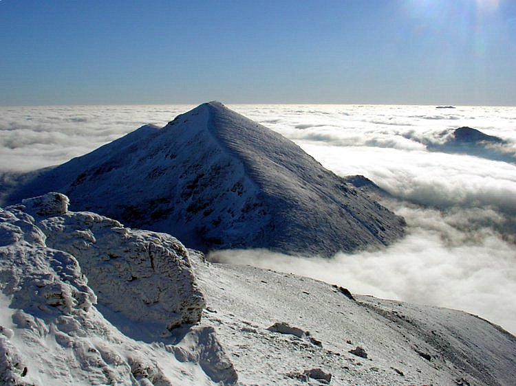
Beinn Narnain from Beinn Ime | |
| Highest point | |
| Elevation | 926 m (3,038 ft)[1] |
| Prominence | 289 m (948 ft) |
| Parent peak | Beinn Ime |
| Listing | Munro, Marilyn |
| Naming | |
| English translation | Hill of notches |
| Language of name | Gaelic |
| Pronunciation | Scottish Gaelic: [peɲ ˈn̪ˠaːrˠnɛɲ] |
| Geography | |
| Location | Arrochar Alps, Argyll and Bute, Grampian Mountains, Scotland |
| OS grid | NN271066 |
| Topo map | OS Landranger 56 |
Beinn Narnain is usually climbed from Succoth at the head of Loch Long. The most commonly used route starts by climbing directly up the hillside, following a line of concrete blocks that were originally supports for a cable railway used during the construction of watercourse diversions forming part of the Loch Sloy hydro-electric scheme[2] (Until the construction of new path, this was also the route towards The Cobbler). At one point the path crosses a level track, and one must continue by climbing some exposed rock immediately opposite - this appears to be part of the stream bed and not the path.
Where the concrete blocks cease, the path continues up Beinn Narnain's craggy south ridge. There are several mild scrambling sections, which provide an enjoyable experience for the casual walker. The route bypasses some impressive and, when shrouded in mist at least, apparently almost impassable crags – "The Spearhead" – by means of a steep gully immediately before the summit. The final stages of the climb include some mild exposure, but this should not intimidate a hillwalker of even limited experience.
Beinn Narnain's northern ridge drops down to the Bealach a' Mhàim, a three-sided bealach with other ridges leading to The Cobbler and Beinn Ìme. An ascent of Beinn may thus easily be extended to give a longer day on the Arrochar Alps.
References
| Wikimedia Commons has media related to Beinn Narnain. |
- "walkhighlands Beinn Narnain". walkhighlands.co.uk. 2013. Retrieved 16 October 2013.
- Undiscovered Scotland. "Beinn Narnain Undiscovered Scotland Feature Page". Archived from the original on 5 June 2007. Retrieved 3 June 2007.
Munros of Scotland: Firth of Clyde to Strath Tay | |||
|---|---|---|---|
 |
|  | |
List of Munros | |||
This Argyll and Bute location article is a stub. You can help Wikipedia by expanding it. |
На других языках
[de] Beinn Narnain
Der Beinn Narnain (auch Ben Narnain) ist ein 926 m (3.038 ft) hoher Berg in Schottland. Sein gälischer Name bedeutet ungefähr Schartiger Berg oder Zerklüfteter Berg.[1] Der Berg ist einer von vier Munros in den Arrochar Alps. Diese Berggruppe liegt zwischen dem nördlichen Ende von Loch Long und dem Westufer von Loch Lomond in den südlichen Highlands im Loch Lomond and the Trossachs National Park. Das Gestein ist überwiegend Glimmerschiefer.[2]- [en] Beinn Narnain
Другой контент может иметь иную лицензию. Перед использованием материалов сайта WikiSort.org внимательно изучите правила лицензирования конкретных элементов наполнения сайта.
WikiSort.org - проект по пересортировке и дополнению контента Википедии