geo.wikisort.org - Mountains
The Arrochar Alps are a group of mountains located around the head of Loch Long, Loch Fyne, and Loch Goil, near the villages of Arrochar and Lochgoilhead, on the Cowal Peninsula in Argyll and Bute, Scotland.[1] The mountains are especially popular with hillwalkers, due to their proximity and accessibility from Glasgow. They are largely within the Loch Lomond and The Trossachs National Park and in part also extend into the Argyll Forest Park. Glens which go into the heart of the range include: Glen Croe, Hell's Glen and Glen Kinglass.
| Arrochar Alps | |
|---|---|
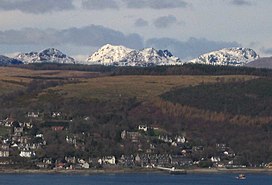
 View across the Firth of Clyde, from about 29 km (18 mi) south of Arrochar. From the left, The Brack, the snowy mass of Beinn Ìme, the peaks of the Cobbler and Beinn Narnain. See a wider view. | |
| Highest point | |
| Peak | Beinn Ìme |
| Elevation | 1,011 m (3,317 ft) |
| Coordinates | 56°14′09″N 4°49′01″W |
| Geography | |
| Country | Scotland |
| Region | Argyll and Bute |
List
The list below includes the Munros, Munro Tops, Corbetts, Corbett Tops and Grahams.
- Munros:
- Beinn Ìme, 1011 m
- Beinn Bhuidhe, 948 m
- Ben Vorlich, 943 m
- Beinn Narnain, 926 m
- Ben Vane, 915 m
- Munro Tops:
- Ben Vorlich (North Top), 931 m
- Corbetts:
- Beinn an Lochain, 901 m
- The Cobbler (Ben Arthur) 884 m
- Beinn Luibhean, 857 m
- Ben Donich, 847 m
- Binnein an Fhidhleir, 817 m
- The Brack, 787 m
- Beinn Bheula, 779 m
- Cnoc Coinnich, 763 m
- Corbett Tops:
- The Cobbler (North Peak), 870 m
- The Cobbler (South Top), 858 m
- A' Chrois, 848 m
- Beinn Chorranach, 848 m
- Little Hills, 808 m
- The Brack (West), 787 m
- Ben Vorlich (South Top), 780 m
- Beinn Dubh, 773 m
- Grahams:
- Stob an Eas, 732 m
- Beinn Lochain, 703 m
- Stob na Boine Druim-fhinn, 658 m
- Creag Tharsuinn, 643 m
- Cruach nam Mult, 611 m
- Other mountains
- Mullach Coire a' Chuir, 639 m
- Cruach nan Capull, 565 m
- Cruach Tairbeirt, 1362 ft, 415 m
- Beinn Reithe, 2,061 ft (628 m)
- The Saddle (Lochgoilhead), 521 m
- Clach Bheinn (Lochgoilhead), 437 m
- Tom Molach, 370 m
- Carn Glas, 502 m
- Tom nan Gamhna, 389 m
- The Steeple (Lochgoilhead), 390 m
- Cruach nam Miseag, 606 m
Areas
- Tarbet (Eastern Gateway alongside Ardlui and Arrochar)
- Arrochar (Eastern Gateway alongside Ardlui and Tarbet
- Succoth, Argyll
- Ardgartan
- Rest and be thankful
- Butterbridge
- Cairndow
- Ardno
- St Catherines
- Strachur (South Western Gateway)
- Lochgoilhead (Heart of the range as it sits on the southern range of mountains of Glen Croe
- Carrick Castle
- Ardlui (Northern and Eastern Gateway alongside Arrochar and Tarbet
Lochs
- Loch Goil (Heart of the range)
- Loch Restil
- Loch Long
- Loch Lomond
- Loch Sloy
- Loch Fyne
Glens
- Glenbranter (Parly)
- Hell's Glen
- Glen Kinglas
- Glen Croe
- Glen Loin
- Tarbet
- Glen Falloch
- Glen Fyne
Parks
- Loch Lomond and the Trossachs National Park
- Argyll Forest Park
- Cowal
- Ardgoil Peninsula
References
- Ordnance Survey: Landranger map sheet 56 Loch Lomond & Inveraray (Map). Ordnance Survey. 2012. ISBN 978-0-319-22981-1.
На других языках
- [en] Arrochar Alps
[it] Alpi Arrochar
Le Alpi Arrochar sono un gruppo di montagne situate intorno alla testa del Loch Long, Loch Fyne e Loch Goil, vicino ai villaggi di Arrochar e Lochgoilhead, sulla penisola di Cowal nella provincia di Argyll e Bute, in Scozia[1]. Le montagne sono particolarmente apprezzate dagli escursionisti, grazie alla loro vicinanza e accessibilità da Glasgow. Sono in gran parte all'interno del Loch Lomond e The Trossachs National Park e in parte si estendono anche nell'Argyll Forest Park. Le glen, che entrano nel cuore della catena, includono: Glen Croe, Hell's Glen e Glen Kinglass.Текст в блоке "Читать" взят с сайта "Википедия" и доступен по лицензии Creative Commons Attribution-ShareAlike; в отдельных случаях могут действовать дополнительные условия.
Другой контент может иметь иную лицензию. Перед использованием материалов сайта WikiSort.org внимательно изучите правила лицензирования конкретных элементов наполнения сайта.
Другой контент может иметь иную лицензию. Перед использованием материалов сайта WikiSort.org внимательно изучите правила лицензирования конкретных элементов наполнения сайта.
2019-2025
WikiSort.org - проект по пересортировке и дополнению контента Википедии
WikiSort.org - проект по пересортировке и дополнению контента Википедии