geo.wikisort.org - Mountains
Knockmealdown (Irish: Cnoc Mhaoldomhnaigh, meaning 'hill of Maoldomhnach') is the highest peak of the Knockmealdown Range of mountains, located on the border between Co Tipperary and Co Waterford.[1]
| Knockmealdown | |
|---|---|
| Cnoc Mhaoldomhnaigh | |
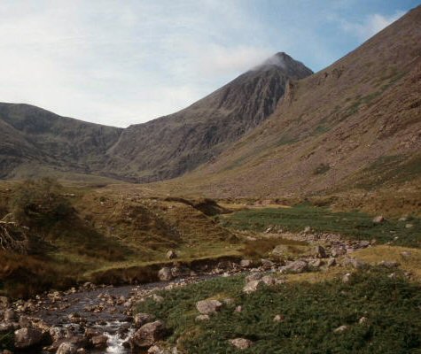
 Knockmealdown east face and summit The screes are steep and barren looking though sheep are grazing | |
| Highest point | |
| Elevation | 792 m (2,598 ft)[1] |
| Prominence | 683 m (2,241 ft)[1] |
| Parent peak | Galtymore |
| Listing | County top (Waterford), P600, Marilyn, Hewitt |
| Coordinates | 52°13′41″N 7°54′57″W |
| Naming | |
| English translation | hill of Maoldomhnaigh[1] |
| Language of name | Irish |
| Geography | |
 Knockmealdown Ireland | |
| Location | Waterford, Republic of Ireland |
| Parent range | Knockmealdown Mountains |
| OSI/OSNI grid | S058084 |
| Topo map | OSi Discovery 74 |
| Geology | |
| Mountain type | Medium grained pink-purple sandstone bedrock[1] |
| Climbing | |
| Easiest route | hiking |
Geography
The peak itself is located in County Waterford and is the highest point in that county. However, since the county border generally follows the summit line the main peaks are actually in both county Tipperary and in County Waterford (OSI Discovery Map 75).
Name
Knockmealdown is the Anglicised form of an older Irish name. The original Irish name is widely believed to be Cnoc Mhaoldomhnaigh, meaning "Muldowneys' hill".[2] It has also been suggested that it is derived from Cnoc Maol Donn, meaning "bald brown hill".[3] In 1654 the name was recorded as Knockmealdowny, indicating there was an extra syllable at the end.[2][3]
Hill walking
The peak is easily accessed from the west, via the layby overlooking Bay Lough on the Vee Gap. This involves first climbing Sugarloaf Hill. It may also be climbed by following the Glannandaree stream from the carpark at the point where the R668 and R669 roads meet.

See also
- Lists of mountains in Ireland
- List of Irish counties by highest point
- List of mountains of the British Isles by height
- List of P600 mountains in the British Isles
- List of Marilyns in the British Isles
- List of Hewitt mountains in England, Wales and Ireland
References
- "Knockmealdown". MountainViews. Retrieved 2 June 2019.
- Placenames Database of Ireland
- "Knockmealdown Mountains". MountainViews. Retrieved 24 February 2009.
| British Isles |  | |
|---|---|---|
| Scotland | ||
| Outside Scotland | ||
| England | ||
| Ireland | ||
| County tops |
| |
Most prominent mountains of Britain and Ireland (the P600s) | ||
|---|---|---|
| Northern Highlands (20) |    | |
| Western Highlands (20) | ||
| Central and Eastern Highlands (13) | ||
| Southern Highlands (15) |
| |
| Islands (13) | ||
| Scottish Lowlands, England and Wales (13) | ||
| Republic of Ireland, Northern Ireland (25) | ||
Highest mountains of Ireland (by province) | ||
|---|---|---|
| Munster |
|  |
| Leinster |
| |
| Ulster |
| |
| Connacht |
| |
List of mountains in Ireland | ||
Mountains and hills of Munster | |||||||
|---|---|---|---|---|---|---|---|
| Ballyhoura Mountains |  | ||||||
| Boggeragh Mountains | |||||||
| Caha Mountains | |||||||
| Comeragh Mountains | |||||||
| Derrynasaggart Mountains | |||||||
| Dingle Peninsula |
| ||||||
| Galty Mountains | |||||||
| Iveragh Peninsula | |||||||
| Knockmealdown Mountains | |||||||
| MacGillycuddy's Reeks |
| ||||||
| Mangerton Mountains | |||||||
| Shehy Mountains | |||||||
| Silvermine Mountains | |||||||
| Slieve Miskish Mountains | |||||||
| Others |
| ||||||
На других языках
- [en] Knockmealdown
[fr] Knockmealdown
Knockmealdown (en irlandais : Cnoc Mhaoldomhnaigh) est une montagne s'élevant à 794 mètres d'altitude à la frontière entre les comtés de Waterford, dont elle est le point culminant, et de Tipperary, en Irlande.[it] Knockmealdown
Il Knockmealdown (in gaelico irlandese Cnoc Mhaoldomhnaigh) è un monte irlandese facente parte della catena dei Monti Knockmealdown, di cui rappresenta la cima più elevata. Situato sul confine tra la contea di Tipperary e la contea di Waterford; la cima è situata su quest'ultima, ed è anche il punto più alto di tale contea.Другой контент может иметь иную лицензию. Перед использованием материалов сайта WikiSort.org внимательно изучите правила лицензирования конкретных элементов наполнения сайта.
WikiSort.org - проект по пересортировке и дополнению контента Википедии