geo.wikisort.org - Mountains
Pico do Areeiro (often wrongly written as Pico do Arieiro), at 1,818 m (5,965 ft) high, is Madeira Island's third highest peak.[2] From the top, visitors can look down on the clouds on most days. The air is fresh and clear and the sun is very bright. On a clear day it is possible to see the neighboring island of Porto Santo, 48 km (30 mi) to the northeast.
| Pico do Areeiro | |
|---|---|
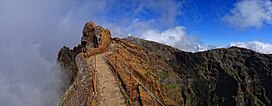
 View of Pico Do Areeiro from the west | |
| Highest point | |
| Elevation | 1,818 m (5,965 ft)[1] |
| Coordinates | 32°44′08″N 16°55′44″W |
| Geography | |
 Pico do Areeiro Location of Pico do Arieiro in Madeira | |
| Location | Madeira |
The footpath northwards towards Pico Ruivo is an important tourist attraction, with a daily average of 1000 tourists trekking on it.
The peak has in recent times become popular with cyclists making the ascent from Funchal. Many cycling publications and online lists usually claim that the climb from sea level to the summit at Areeiro is one of the toughest in the world with 1810 meters of climbing over a very short distance of 22 kilometres.
There is easy road access to the summit, with a large car park, a restaurant and souvenir shop. In 2011, an Air Defence Radar Station of the Portuguese Air Force was built at the top of the mountain near the tourist facilities.


Climate
Pico do Areeiro has a cool Mediterranean climate, surprisingly wet for this type of climate due to the extreme precipitation it gets, a big part of it from drizzle and fog.
| Climate data for Pico do Areeiro, 1961-1990, 1,610 m (5,280 ft) altitude | |||||||||||||
|---|---|---|---|---|---|---|---|---|---|---|---|---|---|
| Month | Jan | Feb | Mar | Apr | May | Jun | Jul | Aug | Sep | Oct | Nov | Dec | Year |
| Average high °C (°F) | 8.1 (46.6) |
8.4 (47.1) |
9.0 (48.2) |
9.0 (48.2) |
11.4 (52.5) |
14.4 (57.9) |
18.5 (65.3) |
18.8 (65.8) |
16.1 (61.0) |
13.2 (55.8) |
10.4 (50.7) |
8.5 (47.3) |
12.1 (53.9) |
| Daily mean °C (°F) | 5.5 (41.9) |
5.6 (42.1) |
6.2 (43.2) |
6.1 (43.0) |
8.2 (46.8) |
11.0 (51.8) |
14.6 (58.3) |
14.8 (58.6) |
12.8 (55.0) |
10.3 (50.5) |
7.8 (46.0) |
6.0 (42.8) |
9.1 (48.3) |
| Average low °C (°F) | 2.9 (37.2) |
2.8 (37.0) |
3.4 (38.1) |
3.2 (37.8) |
5.0 (41.0) |
7.6 (45.7) |
10.7 (51.3) |
10.8 (51.4) |
9.5 (49.1) |
7.4 (45.3) |
5.2 (41.4) |
3.5 (38.3) |
6.0 (42.8) |
| Record low °C (°F) | −3.0 (26.6) |
−4.3 (24.3) |
−4.3 (24.3) |
−6.0 (21.2) |
−0.9 (30.4) |
1.0 (33.8) |
2.4 (36.3) |
4.3 (39.7) |
3.3 (37.9) |
0.0 (32.0) |
−2.5 (27.5) |
−3.0 (26.6) |
−6.0 (21.2) |
| Average precipitation mm (inches) | 437.0 (17.20) |
371.6 (14.63) |
302.4 (11.91) |
211.3 (8.32) |
116.6 (4.59) |
69.8 (2.75) |
13.2 (0.52) |
33.5 (1.32) |
169.7 (6.68) |
306.8 (12.08) |
448.9 (17.67) |
447.0 (17.60) |
2,927.8 (115.27) |
| Source: [3] | |||||||||||||
References
- Pico do Arieiro at peakbagger.com
- Madeira Geography Archived 2011-07-14 at the Wayback Machine
- Quintal, José Raimundo Gomes. "Estudo fitogeográfico dos jardins, parques e quintas do concelho do Funchal" (PDF). University of Lisbon. Retrieved 11 February 2021.
External links
![]() Media related to Pico do Areeiro at Wikimedia Commons
Media related to Pico do Areeiro at Wikimedia Commons
На других языках
[de] Pico do Arieiro
Der Pico do Arieiro (auch Pico do Areeiro) ist mit einer Höhe von 1818 m der dritthöchste Berg Madeiras. Er ist im Gegensatz zu den zwei höheren Gipfeln Pico Ruivo (1861 m) und Pico das Torres (1851 m) mit einer vom Poiso-Pass ausgehenden Straße erschlossen und daher der meistbesuchte Gipfel der Insel. Unterhalb des Gipfels befinden sich zur Bewältigung der alltäglichen Touristenströme ein großer Parkplatz und eine Cafeteria mit Souvenirshop, die Pousada verfällt.- [en] Pico do Areeiro
[fr] Pico do Arieiro
Le Pico do Arieiro (aussi appelé Pico do Areeiro) culmine à 1 818 mètres et forme le troisième sommet de l'île de Madère après le Pico Ruivo et le Pico das Torres. Sa hauteur de culminance permet, par ciel dégagé, une vue panoramique sur la côte nord et la côte sud de l'île. On peut notamment voir la pointe Saint-Laurent.[it] Pico do Arieiro
Il Pico do Arieiro è una montagna di 1.818 metri [1][2] dell'isola portoghese di Madera. È la terza vetta più elevata dell'isola[1][2][3], dopo il Pico Ruivo e il Pico das Torres.[ru] Пику-ду-Ариейру
Пику-ду-Ариейру (порт. Pico do Arieiro) — третья по высоте (1818 м) гора острова Мадейра, главного острова одноимённого архипелага в Атлантическом океане — после Пику-Руйву (1862 м) и Пику-даш-Торреш (1847 м).Другой контент может иметь иную лицензию. Перед использованием материалов сайта WikiSort.org внимательно изучите правила лицензирования конкретных элементов наполнения сайта.
WikiSort.org - проект по пересортировке и дополнению контента Википедии