geo.wikisort.org - Island
Madeira is a Portuguese island, and is the largest and most populous of the Madeira Archipelago. It has an area of 740.7 km2, including Ilhéu de Agostinho, Ilhéu de São Lourenço, Ilhéu Mole (northwest). As of 2011, Madeira had a total population of 262,456.
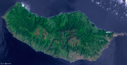 Satellite image of Madeira | |
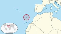 Location of Madeira | |
| Geography | |
|---|---|
| Location | Atlantic Ocean |
| Coordinates | 32°39′4″N 16°54′35″W |
| Archipelago | Madeira Archipelago |
| Adjacent to | Atlantic Ocean |
| Area | 740.7 km2 (286.0 sq mi) |
| Highest point | Pico Ruivo 1,862 m (6,109 ft) |
| Administration | |
Portugal | |
| Autonomous Region | Autonomous Region of Madeira |
| Capital and largest City | Funchal |
| Demographics | |
| Population | 267,785 (2011) |
The island is the top of a massive submerged shield volcano that rises about 6 km (3.7 mi) from the floor of the Atlantic Ocean. The volcano formed atop an east–west rift[1][2] in the oceanic crust along the African Plate, beginning during the Miocene epoch over 5 million years ago, continuing into the Pleistocene until about 700,000 years ago.[3] This was followed by extensive erosion, producing two large amphitheatres open to south in the central part of the island. Volcanic activity later resumed, producing scoria cones and lava flows atop the older eroded shield. The most recent volcanic eruptions were on the west-central part of the island only 6,500 years ago, creating more cinder cones and lava flows.[3]
Madeira is the largest island of the group with an area of 741 km2 (286 sq mi), a length of 57 km (35 mi) (from Ponta de São Lourenço to Ponta do Pargo), while approximately 22 km (14 mi) at its widest point (from Ponta da Cruz to Ponta de São Jorge), with a coastline of 150 km (90 mi). It has a mountain ridge that extends along the centre of the island, reaching 1,862 m (6,109 ft) at its highest point (Pico Ruivo), while much lower (below 200 metres) along its eastern extent. The primitive volcanic foci responsible for the central mountainous area, consisted of the peaks: Ruivo (1,862 m), Torres (1,851 m), Arieiro (1,818 m), Cidrão (1,802 m), Cedro (1,759 m), Casado (1,725 m), Grande (1,657 m), Ferreiro (1,582 m). At the end of this eruptive phase, an island circled by reefs was formed, its marine vestiges are evident in a calcareous layer in the area of Lameiros, in São Vicente (which was later explored for calcium oxide production). Sea cliffs, such as Cabo Girão, valleys and ravines extend from this central spine, making the interior generally inaccessible.[4] Daily life is concentrated in the many villages at the mouths of the ravines, through which the heavy rains of autumn and winter usually travel to the sea.[5]


See also
- Madeira, the archipelago and Autonomous Region named after Madeira Island
References
- Geldemacher et al., 2000
- Ribeiro, 2001
- "Madeira". Global Volcanism Program. Smithsonian Institution.
- "MadeiraHelp.com". MadeiraHelp.com. 22 February 1999. Archived from the original on 31 July 2010. Retrieved 30 July 2010.
- Robert White, 1851, p.4
Authority control | |
|---|---|
| General | |
| National libraries | |
На других языках
[de] Madeira
Madeira [.mw-parser-output .IPA a{text-decoration:none}maˈdeːʁa] (von portugiesisch madeira für „Holz“) ist eine portugiesische Insel, 951 km südwestlich von Lissabon und 737 km westlich der marokkanischen Küste im Atlantischen Ozean. Sie gehört mit der kleineren Insel Porto Santo und der unbewohnten kleineren Inselgruppe Ilhas Desertas zur Inselgruppe Madeira, die gemeinsam mit den ebenfalls unbewohnten Ilhas Selvagens die Autonome Region Madeira bildet.- [en] Madeira Island
[es] Isla de Madeira
La isla de Madeira (en portugués, ilha da Madeira; adaptada al español como isla de Madera, hoy en desuso),[1] es una isla del archipiélago de Madeira situado en el océano Atlántico, al oeste de la costa africana, y que constituye conjuntamente con Porto Santo, las islas Desertas y las islas Salvajes, la Región Autónoma de Madeira, en Portugal.[fr] Île de Madère
L'île de Madère (en portugais : Ilha da Madeira) est l'île principale de l'archipel et région autonome de Madère dépendant du Portugal.[ru] Мадейра (остров)
О́стров Маде́йра (порт. Ilha da Madeira) — главный остров одноимённого архипелага, находящегося в северной части Атлантического океана у северо-западного побережья Африки. Хотя остров расположен на Африканской литосферной плите, он уже почти шесть веков этнически, культурно, политически и экономически вполне относится к Европе. Вместе с другим заселённым островом архипелага Порту-Санту, а также островами Ильяш-Дезерташ и Селваженш образует Автономный регион Мадейры со столицей в городе Фуншале. Принадлежит Португалии[1].Другой контент может иметь иную лицензию. Перед использованием материалов сайта WikiSort.org внимательно изучите правила лицензирования конкретных элементов наполнения сайта.
WikiSort.org - проект по пересортировке и дополнению контента Википедии