geo.wikisort.org - IslandVictoria Island is an island in the Sacramento-San Joaquin River Delta, 20 km (12 mi) southwest of Stockton.[1] The 7,200-acre (2,900 ha) island is bounded on the north by North Victoria Canal, on the northeast by Middle River, on the southeast by Victoria Canal, and on the south- and southwest Old River. It is crossed by California State Route 4.[2] It is in San Joaquin County, and managed by Reclamation District 2040.[3] It appears on 1913 and 1952 United States Geological Survey maps of the area.[4][5]
Victoria Island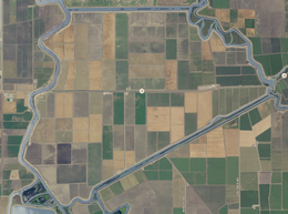 USGS aerial imagery of Victoria Island |
Show map of Sacramento-San Joaquin River Delta Show map of the United States |
|
| Location | Northern California |
|---|
| Coordinates | 37.889925°N 121.534672°W / 37.889925; -121.534672 |
|---|
| Adjacent bodies of water | Sacramento-San Joaquin River Delta |
|---|
| Area | 7,200 acres (2,900 ha) |
|---|
|
United States |
| State |  California California |
|---|
| County | San Joaquin |
|---|
Buried impact structure
Main article: Victoria Island Structure
Oil exploration led to the discovery of a possible buried impact structure in the sediments under the island. It was named the Victoria Island Structure after the island.[6][7]
See also
References
- "Victoria Island". Geographic Names Information System. United States Geological Survey.
- https://www.google.com/maps/place/Victoria+Island/@37.8996282,-121.5586859,13.41z/data=!4m5!3m4!1s0x809004aa4e357c97:0x3e325cb8da5b40c5!8m2!3d37.8899253!4d-121.5346722 Google Maps shows it as a cross with route 4
- "Municipal Service Review: Selected San Joaquin County Reclamation Districts" (PDF). San Joaquin Local Agency Formation Commission. E Mulberg & Associates. 18 March 2018. Retrieved 24 February 2021.
- Marshall, R.B.; Gerdine, T.G.; Hannegan, Duncan; Lewis, J.L. (1913). "Topography, State of California: Woodward Island Quadrangle". United States Geological Survey. Archived from the original on 5 April 2020. Retrieved 25 February 2021.
- United States Geological Survey (1952). "Woodward Island Quadrangle, California" (Map). United States Department of the Interior Geological Survey. 1:24000.
- Spevack, S. C., Morrow, J. R., Spevack, B. Z. (2007). "3-D seismic and well log analyses of the Victoria Island Structure, a Potential Buried Impact Crater, San Joaquin County, California" (.PDF). Lunar and Planetary Science Conference XXXVIII. Retrieved 2009-09-17. CS1 maint: multiple names: authors list (link)
- Roach, John (2007-03-27). "Giant Meteorite Hit Ancient California, Crater Study Suggests". National Geographic News. National Geographic Society. Retrieved 2009-09-01.
|
|---|
 (islands of
the San
Francisco
Bay Area) |
|
|---|
| Outline | | |
|---|
| Subdivisions | |
|---|
| Waterways | |
|---|
Parks and
protected areas |
- Don Edwards National Wildlife Refuge
- San Pablo Bay National Wildlife Refuge
- Eden Landing Ecological Reserve
- Hayward Regional Shoreline
- Hayward Shoreline Interpretive Center
- Crown Memorial State Beach
- McLaughlin Eastshore State Park
- Emeryville Crescent State Marine Reserve
- Point Isabel Regional Shoreline
- César Chávez Park
- Brooks Island Regional Preserve
- Point Pinole Regional Shoreline
- Antioch Dunes National Wildlife Refuge
- Coyote Point Recreation Area
- Middle Harbor Shoreline Park
- National Estuarine Research Reserve
- China Camp State Park
- San Francisco Maritime National Historical Park
- SF Bay Trail
- Oyster Bay Regional Shoreline
- Big Break Regional Shoreline
- Palo Alto Baylands Nature Preserve
|
|---|
Islands and
peninsulas | |
|---|
| Wetlands |
- Baylands
- Belmont
- Chelsea
- Cordelia
- Crissy Field
- Hoffman
- Meeker
- Mowry
- Napa Sonoma
- Point Molate
- Salt ponds
- Seal
- Stege
- Steinberger
- Suisun
- Westpoint
|
|---|
Bridges
and tubes |
- Bridges
- San Francisco–Oakland
- Eastern span replacement
- Richmond–San Rafael
- San Mateo–Hayward
- Dumbarton
- Dumbarton Rail Bridge (inactive)
- Golden Gate
- Benicia–Martinez
- Antioch
- Carquinez
- Leimert
- Park Street
- Fruitvale
- High Street
- Bay Farm Island
- Tubes
- Posey/Webster Street
- Transbay
|
|---|
| Ferries |
- Angel Island–Tiburon Ferry
- Blue & Gold Fleet
- Golden Gate Ferry
- San Francisco Bay Ferry (WETA)
|
|---|
Ports and
marinas |
- Port of San Francisco
- Port of Oakland
- Port of Richmond
- Hunters Point Naval Shipyard
- Mare Island Naval Shipyard
- Port of Redwood City
- Berkeley Marina
- Oyster Point Marina/Park
- Westpoint Harbor
- Foster City Marina (proposed)
|
|---|
| Other |
- History
- Delta and Dawn
- Discovery Site
- Humphrey the Whale
- San Leandro Oyster Beds
- Richmond Shipyards
- U.S. Army Corps of Engineers Bay Model
- Harold Gilliam
- Marincello
- Ecology
- Golden Gate Biosphere Reserve
- Cosco Busan oil spill
- Thicktail chub
- Delta smelt
- Conservation and Development Commission
- The Watershed Project
- Save The Bay
- Citizens for East Shore Parks
- Friends of Five Creeks
- Urban Creeks Council
- 1971 oil spill
- Greenbelt Alliance
- The Bay Institute
- Reber Plan
- San Francisco Baykeeper
- San Francisco Estuary and Watershed Science
- Estuary Partnership
- Transportation
- Ridgway's rail/California clapper rail
- Water Trail
- Transportation in the San Francisco Bay Area
|
|---|
 Portal Portal Category Category
|
|
|---|
| Counties |
- Contra Costa
- Sacramento
- San Joaquin
- Solano
- Yolo
|
|---|
| Cities and towns | |
|---|
| Islands | |
|---|
| Waterways | Rivers, creeks
and sloughs |
- American River
- Beaver Slough
- Broad Slough
- Cache Slough
- Calaveras River
- Connection Slough
- Disappointment Slough
- Dutch Slough
- Elk Slough
- False River
- Fourteenmile Slough
- French Camp Slough
- Georgiana Slough
- Hog Slough
- Indian Slough
- Latnam Slough
- Lindsey Slough
- Lookout Slough
- Marsh Creek
- Mayberry Slough
- Middle River
- Miner Slough
- Mokelumne River
- New York Slough
- Old River
- Potato Slough
- Prospect Slough
- Sacramento River
- San Joaquin River
- Sand Mound Slough
- Sevenmile Slough
- Shag Slough
- Snodgrass Slough
- Steamboat Slough
- Stockton Channel
- Sycamore Slough
- Taylor Slough
- Rock Slough
- Threemile Slough
- Tom Paine Slough
- Trapper Slough
- Whiskey Slough
- White Slough
|
|---|
Man-made
channels |
- Bishop Cut
- Columbia Cut
- Delta Cross Channel
- Fishermans Cut
- Hastings Cut
- Holland Cut
- Honker Cut
- North Victoria Canal
- Paradise Cut
- Sacramento River Deep Water Ship Channel
- Stockton Deepwater Shipping Channel
- Victoria Canal
- Woodward Canal
|
|---|
|
|---|
| Other features | |
|---|
Water supply
infrastructure |
- Banks Pumping Plant
- C.W. Bill Jones Pumping Plant
- California Aqueduct
- Clifton Court Forebay
- Contra Costa Canal
- Delta-Mendota Canal
- Mokelumne Aqueduct
- South Bay Aqueduct
- Peripheral Canal
- Bay Delta Conservation Plan
|
|---|
| Designated areas |
- Big Break Regional Shoreline
- Brannan Island State Recreation Area
- Franks Tract State Recreation Area
- Sherman Island Waterfowl Management Area
- Stone Lakes National Wildlife Refuge
- Woodbridge Ecological Reserve
|
|---|
Текст в блоке "Читать" взят с сайта "Википедия" и доступен по лицензии Creative Commons Attribution-ShareAlike; в отдельных случаях могут действовать дополнительные условия.
Другой контент может иметь иную лицензию. Перед использованием материалов сайта WikiSort.org внимательно изучите правила лицензирования конкретных элементов наполнения сайта.
2019-2026
WikiSort.org - проект по пересортировке и дополнению контента Википедии


