geo.wikisort.org - Island
West Island is a small island in the San Joaquin River, California.[2][3][4][5][6][7][8][9][10][11][12][13][14][15][16][17] It is part of Sacramento County. Its coordinates are 38°01′24″N 121°46′43″W[1]. It is shown, labeled "Webers Island", on an 1850 survey map of the San Francisco Bay area made by Cadwalader Ringgold[18] and an 1854 map of the area by Henry Lange.[19]
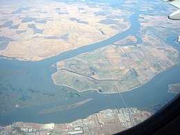
 West Island is the long, thin island in the bottom left of this photo. The larger island is Sherman Island, and the bridge goes down to Antioch. | |
 West Island  West Island  West Island  West Island | |
| Geography | |
|---|---|
| Location | Northern California |
| Coordinates | 38°01′24″N 121°46′43″W[1] |
| Adjacent bodies of water | San Joaquin River |
| Administration | |
United States | |
| State | |
| County | Sacramento |
References
- U.S. Geological Survey Geographic Names Information System: West Island
- California State Automobile Association (1999). San Francisco Bay Region (Map). 1:190,000. American Automobile Association.
- "Islands in San Joaquin River for Sale". The Record-Union. Sacramento, California. 1884-11-04. p. 3.
- "Bridge Replaces Ferries in Bay Road Plan". The Sacramento Bee. Sacramento, California. 1921-12-31. p. 21.
- "Antioch Notes". Oakland Tribune. Oakland, California. 1922-07-11. p. 16.
- "Chambers to Boost Great Road Project". San Francisco Chronicle. San Francisco, California. 1922-08-06. p. 12.
- "Sherman Island Bridge Project Gains In Favor". Stockton Daily Evening Record. Stockton, California. 1922-08-10. p. 12.
- "Land Of Great Fertility Is Tapped By New Route". The Sacramento Bee. Sacramento, California. 1925-12-29. p. 20.
- "17 Ships of War Time Set Afire to Clear River". Contra Costa Gazette. Martinez, California. 1927-09-29. p. 6.
- "A Line on the Sportsman". Oakland Tribune. Oakland, California. 1936-09-06. p. 10.
- "Rod and Gun". The San Francisco Examiner. San Francisco, California. 1952-01-30. p. 26.
- "Fishing Now Tops for Striped Bass". Oakland Tribune. Oakland, California. 1958-11-13. p. 56.
- "Delta Fishing!". Concord Transcript. Concord, California. 1967-05-26. p. 11.
- "Outdoor Dateline: Waterfowl rewards few". The Berkeley Gazette. Berkeley, California. 1977-12-22. p. 29.
- "Delta". Oakland Tribune. Oakland, California. 1980-10-05. p. 25.
- "Fishing Report". The Modesto Bee. Modesto, California. 1993-11-11. p. 17.
- "Fish report". The Modesto Bee. Modesto, California. 2004-05-13. p. 34.
- Ringgold, Cadwalader; Stuart, Fred D.; Everett, Chas.; Harrison (1850). "General Chart embracing Surveys of the Farallones Entrance to the Bay of San Francisco, Bays of San Francisco and San Pablo, Straits of Carquines and Suisun Bay, and the Sacramento and San Joaquin Rivers, to the Cities of Sacramento and San Joaquin, California". David Rumsey Map Collection. San Francisco Common Council. Archived from the original on 7 July 2017. Retrieved 25 February 2021.
- Lange, Henry (1854). "Bai San Francisco und Vereinigung des Sacramento mit dem San Joaquin". David Rumsey Map Collection. George Westermann. Archived from the original on 10 March 2016. Retrieved 25 February 2021.
Текст в блоке "Читать" взят с сайта "Википедия" и доступен по лицензии Creative Commons Attribution-ShareAlike; в отдельных случаях могут действовать дополнительные условия.
Другой контент может иметь иную лицензию. Перед использованием материалов сайта WikiSort.org внимательно изучите правила лицензирования конкретных элементов наполнения сайта.
Другой контент может иметь иную лицензию. Перед использованием материалов сайта WikiSort.org внимательно изучите правила лицензирования конкретных элементов наполнения сайта.
2019-2025
WikiSort.org - проект по пересортировке и дополнению контента Википедии
WikiSort.org - проект по пересортировке и дополнению контента Википедии

