geo.wikisort.org - IslandJersey Island is an island in the Sacramento-San Joaquin River Delta of Contra Costa County, California, approximately 10 kilometres (6.2 mi) east of Antioch. The 1,425-hectare (3,520-acre) bounded on the west by the San Joaquin River-Stockton Deepwater Shipping Channel, on the north by the False River, on the northeast by Piper Slough, on the east by Taylor Slough, and on the south by Dutch Slough. It is administered by Reclamation District 830.[1]
Island in northern California, United States
Jersey Island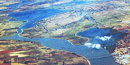 Jersey Island is the top-center island in this aerial photo, with Sherman Island to its left/bottom and Antioch to its right/bottom. |
Show map of Sacramento-San Joaquin River Delta Show map of San Francisco Bay Area Show map of the United States |
|
| Location | Northern California |
|---|
| Coordinates | 38.036310°N 121.685787°W / 38.036310; -121.685787 |
|---|
| Adjacent bodies of water | Sacramento-San Joaquin River Delta |
|---|
| Area | 3,520 acres (1,420 ha) |
|---|
|
United States |
| State |  California California |
|---|
| County | Contra Costa |
|---|
See also
References
|
|---|
 (islands of
the San
Francisco
Bay Area) |
|
|---|
| Outline | | |
|---|
| Subdivisions | |
|---|
| Waterways | |
|---|
Parks and
protected areas |
- Don Edwards National Wildlife Refuge
- San Pablo Bay National Wildlife Refuge
- Eden Landing Ecological Reserve
- Hayward Regional Shoreline
- Hayward Shoreline Interpretive Center
- Crown Memorial State Beach
- McLaughlin Eastshore State Park
- Emeryville Crescent State Marine Reserve
- Point Isabel Regional Shoreline
- César Chávez Park
- Brooks Island Regional Preserve
- Point Pinole Regional Shoreline
- Antioch Dunes National Wildlife Refuge
- Coyote Point Recreation Area
- Middle Harbor Shoreline Park
- National Estuarine Research Reserve
- China Camp State Park
- San Francisco Maritime National Historical Park
- SF Bay Trail
- Oyster Bay Regional Shoreline
- Big Break Regional Shoreline
- Palo Alto Baylands Nature Preserve
|
|---|
Islands and
peninsulas | |
|---|
| Wetlands |
- Baylands
- Belmont
- Chelsea
- Cordelia
- Crissy Field
- Hoffman
- Meeker
- Mowry
- Napa Sonoma
- Point Molate
- Salt ponds
- Seal
- Stege
- Steinberger
- Suisun
- Westpoint
|
|---|
Bridges
and tubes |
- Bridges
- San Francisco–Oakland
- Eastern span replacement
- Richmond–San Rafael
- San Mateo–Hayward
- Dumbarton
- Dumbarton Rail Bridge (inactive)
- Golden Gate
- Benicia–Martinez
- Antioch
- Carquinez
- Leimert
- Park Street
- Fruitvale
- High Street
- Bay Farm Island
- Tubes
- Posey/Webster Street
- Transbay
|
|---|
| Ferries |
- Angel Island–Tiburon Ferry
- Blue & Gold Fleet
- Golden Gate Ferry
- San Francisco Bay Ferry (WETA)
|
|---|
Ports and
marinas |
- Port of San Francisco
- Port of Oakland
- Port of Richmond
- Hunters Point Naval Shipyard
- Mare Island Naval Shipyard
- Port of Redwood City
- Berkeley Marina
- Oyster Point Marina/Park
- Westpoint Harbor
- Foster City Marina (proposed)
|
|---|
| Other |
- History
- Delta and Dawn
- Discovery Site
- Humphrey the Whale
- San Leandro Oyster Beds
- Richmond Shipyards
- U.S. Army Corps of Engineers Bay Model
- Harold Gilliam
- Marincello
- Ecology
- Golden Gate Biosphere Reserve
- Cosco Busan oil spill
- Thicktail chub
- Delta smelt
- Conservation and Development Commission
- The Watershed Project
- Save The Bay
- Citizens for East Shore Parks
- Friends of Five Creeks
- Urban Creeks Council
- 1971 oil spill
- Greenbelt Alliance
- The Bay Institute
- Reber Plan
- San Francisco Baykeeper
- San Francisco Estuary and Watershed Science
- Estuary Partnership
- Transportation
- Ridgway's rail/California clapper rail
- Water Trail
- Transportation in the San Francisco Bay Area
|
|---|
 Portal Portal Category Category
|
|
|---|
| Counties | |
|---|
| Cities and towns | |
|---|
| Islands | |
|---|
| Waterways | Rivers, creeks
and sloughs |
- American River
- Beaver Slough
- Broad Slough
- Cache Slough
- Calaveras River
- Connection Slough
- Disappointment Slough
- Dutch Slough
- Elk Slough
- False River
- Fourteenmile Slough
- French Camp Slough
- Georgiana Slough
- Hog Slough
- Indian Slough
- Latnam Slough
- Lindsey Slough
- Lookout Slough
- Marsh Creek
- Mayberry Slough
- Middle River
- Miner Slough
- Mokelumne River
- New York Slough
- Old River
- Potato Slough
- Prospect Slough
- Sacramento River
- San Joaquin River
- Sand Mound Slough
- Sevenmile Slough
- Shag Slough
- Snodgrass Slough
- Steamboat Slough
- Stockton Channel
- Sycamore Slough
- Taylor Slough
- Rock Slough
- Threemile Slough
- Tom Paine Slough
- Trapper Slough
- Whiskey Slough
- White Slough
|
|---|
Man-made
channels |
- Bishop Cut
- Columbia Cut
- Delta Cross Channel
- Fishermans Cut
- Hastings Cut
- Holland Cut
- Honker Cut
- North Victoria Canal
- Paradise Cut
- Sacramento River Deep Water Ship Channel
- Stockton Deepwater Shipping Channel
- Victoria Canal
- Woodward Canal
|
|---|
|
|---|
| Other features | |
|---|
Water supply
infrastructure |
- Banks Pumping Plant
- C.W. Bill Jones Pumping Plant
- California Aqueduct
- Clifton Court Forebay
- Contra Costa Canal
- Delta-Mendota Canal
- Mokelumne Aqueduct
- South Bay Aqueduct
- Peripheral Canal
- Bay Delta Conservation Plan
|
|---|
| Designated areas |
- Big Break Regional Shoreline
- Brannan Island State Recreation Area
- Franks Tract State Recreation Area
- Sherman Island Waterfowl Management Area
- Stone Lakes National Wildlife Refuge
- Woodbridge Ecological Reserve
|
|---|
Текст в блоке "Читать" взят с сайта "Википедия" и доступен по лицензии Creative Commons Attribution-ShareAlike; в отдельных случаях могут действовать дополнительные условия.
Другой контент может иметь иную лицензию. Перед использованием материалов сайта WikiSort.org внимательно изучите правила лицензирования конкретных элементов наполнения сайта.
2019-2026
WikiSort.org - проект по пересортировке и дополнению контента Википедии


