geo.wikisort.org - Island
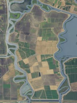
Bacon Island is an island in the Sacramento-San Joaquin River Delta, twenty kilometres east of Antioch, and twenty kilometres west of Stockton.[2] The 2,200 ha (5,400-acre) island is bounded on the west by Old River, on the north by Connection Slough, on the east by Middle River, and Woodward Island Canal on the south.[3] It is in San Joaquin County, and managed by Reclamation District 2028.[4] It appears on 1913 and 1952 United States Geological Survey maps of the area.[5][6]
 | |
 Bacon Island  Bacon Island  Bacon Island | |
| Geography | |
|---|---|
| Location | Northern California |
| Coordinates | 37.976590°N 121.552174°W[1] |
| Adjacent bodies of water | San Joaquin River |
| Administration | |
United States | |
| State | |
| County | Sacramento |
See also
References
- U.S. Geological Survey Geographic Names Information System: Bacon Island
- "Bond Men Visit Phillips Company's Island Holdings". The Evening Mail. Stockton, California. 1913-01-11. p. 6.
- Woodward Island, Bacon Island, Page 036 (San Joaquin County 1911) Historic Map Works, Residential Genealogy
- "Municipal Service Review: Selected San Joaquin County Reclamation Districts" (PDF). San Joaquin Local Agency Formation Commission. E Mulberg & Associates. 18 March 2018. Retrieved 24 February 2021.
- Marshall, R.B.; Gerdine, T.G.; Hannegan, Duncan; Lewis, J.L. (1913). "Topography, State of California: Woodward Island Quadrangle". United States Geological Survey. Archived from the original on 5 April 2020. Retrieved 25 February 2021.
- United States Geological Survey (1952). "Woodward Island Quadrangle, California" (Map). United States Department of the Interior Geological Survey. 1:24000.
Map: Islands of Suisun Bay and the Sacramento–San Joaquin River Delta | |
|---|---|
 Rough and Ready (islands of the San Francisco Bay Area) |
San Francisco Bay watershed | ||
|---|---|---|
| Outline |
|  |
| Subdivisions |
| |
| Waterways |
| |
| Parks and protected areas |
| |
| Islands and peninsulas |
| |
| Wetlands |
| |
| Bridges and tubes |
| |
| Ferries |
| |
| Ports and marinas |
| |
| Other |
| |
| ||
This San Joaquin County, California–related article is a stub. You can help Wikipedia by expanding it. |
Текст в блоке "Читать" взят с сайта "Википедия" и доступен по лицензии Creative Commons Attribution-ShareAlike; в отдельных случаях могут действовать дополнительные условия.
Другой контент может иметь иную лицензию. Перед использованием материалов сайта WikiSort.org внимательно изучите правила лицензирования конкретных элементов наполнения сайта.
Другой контент может иметь иную лицензию. Перед использованием материалов сайта WikiSort.org внимательно изучите правила лицензирования конкретных элементов наполнения сайта.
2019-2026
WikiSort.org - проект по пересортировке и дополнению контента Википедии
WikiSort.org - проект по пересортировке и дополнению контента Википедии