geo.wikisort.org - Island
Mildred Island is a submerged island in the San Joaquin River delta, in California.[2][3] It is part of San Joaquin County. It flooded in 1983, and the land was abandoned.[4] Its coordinates are 37.9863117°N 121.5230069°W[1]. It appears on 1913 and 1952 United States Geological Survey maps of the area.[5][6]
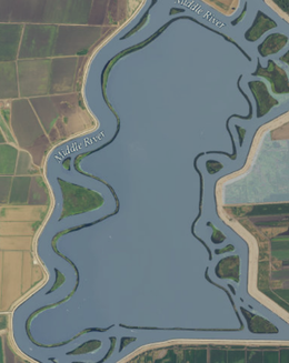 USGS aerial imagery of Mildred Island; the only part that remains above water is its levees. | |
 Mildred Island  Mildred Island  Mildred Island | |
| Geography | |
|---|---|
| Location | Northern California |
| Coordinates | 37.9863117°N 121.5230069°W[1] |
| Adjacent bodies of water | Sacramento–San Joaquin River Delta |
| Administration | |
United States | |
| State | |
| County | San Joaquin |

References
- U.S. Geological Survey Geographic Names Information System: Mildred Island
- "Delta/Stockton". The Fresno Bee. Fresno, California. 2006-08-30. p. D5.
- "Fish Report, Delta/Stockton". The Modesto Bee. Modesto, California. 2019-12-04. p. B5.
- | url = https://californiawaterblog.com/2013/06/17/the-delta-wont-rise-again/
- Marshall, R.B.; Gerdine, T.G.; Hannegan, Duncan; Lewis, J.L. (1913). "Topography, State of California: Woodward Island Quadrangle". United States Geological Survey. Archived from the original on 5 April 2020. Retrieved 25 February 2021.
- United States Geological Survey (1952). "Woodward Island Quadrangle, California" (Map). United States Department of the Interior Geological Survey. 1:24000.
Map: Islands of Suisun Bay and the Sacramento–San Joaquin River Delta | |
|---|---|
 Rough and Ready (islands of the San Francisco Bay Area) |
San Francisco Bay watershed | ||
|---|---|---|
| Outline |
|  |
| Subdivisions |
| |
| Waterways |
| |
| Parks and protected areas |
| |
| Islands and peninsulas |
| |
| Wetlands |
| |
| Bridges and tubes |
| |
| Ferries |
| |
| Ports and marinas |
| |
| Other |
| |
| ||
This San Joaquin County, California–related article is a stub. You can help Wikipedia by expanding it. |
Текст в блоке "Читать" взят с сайта "Википедия" и доступен по лицензии Creative Commons Attribution-ShareAlike; в отдельных случаях могут действовать дополнительные условия.
Другой контент может иметь иную лицензию. Перед использованием материалов сайта WikiSort.org внимательно изучите правила лицензирования конкретных элементов наполнения сайта.
Другой контент может иметь иную лицензию. Перед использованием материалов сайта WikiSort.org внимательно изучите правила лицензирования конкретных элементов наполнения сайта.
2019-2026
WikiSort.org - проект по пересортировке и дополнению контента Википедии
WikiSort.org - проект по пересортировке и дополнению контента Википедии