geo.wikisort.org - Island
Shenkel Island is a small island in the Sacramento–San Joaquin River Delta.[2] It is part of San Joaquin County, California. Its coordinates are 37°58′03″N 121°21′40″W[1], and the United States Geological Survey gives its elevation as 7 ft (2.1 m).[1][3]
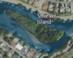 USGS aerial imagery of Shenkel Island, with Sargent-Barnhart Tract to the north across the Calaveras River. | |
 Shenkel Island  Shenkel Island  Shenkel Island | |
| Geography | |
|---|---|
| Location | Northern California |
| Coordinates | 37°58′03″N 121°21′40″W[1] |
| Adjacent to | Sacramento–San Joaquin River Delta |
| Highest elevation | 7 ft (2.1 m)[1] |
| Administration | |
United States | |
| State | |
| County | San Joaquin |
References
- U.S. Geological Survey Geographic Names Information System: Shenkel Island
- "Bids For San Joaquin Work Will Be Opened". The Sacramento Bee. Sacramento, California. 1940-02-19. p. 5.
- United States Geological Survey (2015). "Stockton West Quadrangle, California" (Map). United States Department of the Interior Geological Survey. 1:24000.
Map: Islands of Suisun Bay and the Sacramento–San Joaquin River Delta | |
|---|---|
 Rough and Ready (islands of the San Francisco Bay Area) |
San Francisco Bay watershed | ||
|---|---|---|
| Outline |
|  |
| Subdivisions |
| |
| Waterways |
| |
| Parks and protected areas |
| |
| Islands and peninsulas |
| |
| Wetlands |
| |
| Bridges and tubes |
| |
| Ferries |
| |
| Ports and marinas |
| |
| Other |
| |
| ||
This San Joaquin County, California–related article is a stub. You can help Wikipedia by expanding it. |
Текст в блоке "Читать" взят с сайта "Википедия" и доступен по лицензии Creative Commons Attribution-ShareAlike; в отдельных случаях могут действовать дополнительные условия.
Другой контент может иметь иную лицензию. Перед использованием материалов сайта WikiSort.org внимательно изучите правила лицензирования конкретных элементов наполнения сайта.
Другой контент может иметь иную лицензию. Перед использованием материалов сайта WikiSort.org внимательно изучите правила лицензирования конкретных элементов наполнения сайта.
2019-2026
WikiSort.org - проект по пересортировке и дополнению контента Википедии
WikiSort.org - проект по пересортировке и дополнению контента Википедии