geo.wikisort.org - Island
Vulcan Island (also known as Shipyard Island)[1] is a small island in the Sacramento–San Joaquin River Delta.[7][8][9][10][11] It is part of San Joaquin County, California.[12][13][14][15][16] Its coordinates are 37°59′21″N 121°24′22″W[1], and the United States Geological Survey measured its elevation as 7 ft (2.1 m) in 1981.[1] It appears on a 1952 USGS map of the area.[17]
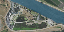 USGS aerial imagery of Vulcan Island | |
 Vulcan Island  Vulcan Island  Vulcan Island | |
| Geography | |
|---|---|
| Location | Northern California |
| Coordinates | 37°59′21″N 121°24′22″W[1] |
| Adjacent bodies of water | Sacramento–San Joaquin River Delta |
| Area | 20 acres (8.1 ha)[2][3][4][5][6] |
| Highest elevation | 7 ft (2.1 m)[1] |
| Administration | |
United States | |
| State | |
| County | San Joaquin |
References
- U.S. Geological Survey Geographic Names Information System: Vulcan Island
- "State Will Auction Two Island Islands". The San Bernardino County Sun. San Bernardino, California. 1956-02-05. p. 4.
- "State To Sell Two Islands". The Pomona Progress Bulletin. Pomona, California. 1956-02-07. p. 10.
- "Want Little Isle? Two Are for Sale". Oakland Tribune. Oakland, California. 1956-02-12. p. 121.
- "Rancher Acquires Vulcan Island in State Auction Sale". Tracy Press. Tracy, California. 1956-03-09. p. 1.
- "Stockton Islands Bring $19,000 At State Auction". The Sacramento Bee. Sacramento, California. 1956-03-09. p. 27.
- "A Record Of Accomplishment In Waterway Campaign". Stockton Daily Evening Record. Stockton, California. 1920-10-22. p. 8.
- "Wright Tract (Including Vulcan Island)". Stockton Independent. Stockton, California. 1936-08-21. p. 8.
- "Son of Fairchild Teacher Stand-In for "Huck Finn"". Tracy Press. Tracy, California. 1959-10-08. p. 19.
- "Delta Memories". The Fresno Bee The Republican. Fresno, California. 1972-12-18. p. 19.
- "Channel Star Sails Again". The Hanford Sentinel. Hanford, California. 1974-09-04. p. 22.
- "News of the water front". San Francisco Chronicle. San Francisco, California. 1907-03-24. p. 59.
- "Mortgages". Stockton Daily Evening Record. Stockton, California. 1914-01-14. p. 9.
- "Mortgages". Stockton Daily Evening Record. Stockton, California. 1915-07-26. p. 7.
- "Washington report features airplane view of harbor". Stockton Daily Evening Record. Stockton, California. 1920-01-31. p. 9.
- "Ordinance No. 1103". Stockton Daily Independent. Stockton, California. 1928-12-29. p. 11.
- United States Geological Survey (1952). "Holt Quadrangle, California" (Map). United States Department of the Interior Geological Survey. 1:24000.
Map: Islands of Suisun Bay and the Sacramento–San Joaquin River Delta | |
|---|---|
 Rough and Ready (islands of the San Francisco Bay Area) |
San Francisco Bay watershed | ||
|---|---|---|
| Outline |
|  |
| Subdivisions |
| |
| Waterways |
| |
| Parks and protected areas |
| |
| Islands and peninsulas |
| |
| Wetlands |
| |
| Bridges and tubes |
| |
| Ferries |
| |
| Ports and marinas |
| |
| Other |
| |
| ||
This San Joaquin County, California–related article is a stub. You can help Wikipedia by expanding it. |
Текст в блоке "Читать" взят с сайта "Википедия" и доступен по лицензии Creative Commons Attribution-ShareAlike; в отдельных случаях могут действовать дополнительные условия.
Другой контент может иметь иную лицензию. Перед использованием материалов сайта WikiSort.org внимательно изучите правила лицензирования конкретных элементов наполнения сайта.
Другой контент может иметь иную лицензию. Перед использованием материалов сайта WikiSort.org внимательно изучите правила лицензирования конкретных элементов наполнения сайта.
2019-2025
WikiSort.org - проект по пересортировке и дополнению контента Википедии
WikiSort.org - проект по пересортировке и дополнению контента Википедии