geo.wikisort.org - Island
Long Island is a small island in the Sacramento–San Joaquin River Delta.[2][3] It is part of Sacramento County, California. Its coordinates are 38°10′01″N 121°37′30″W[1], and the United States Geological Survey measured its elevation as 7 ft (2.1 m) in 1981.[1] It appears on 1978 USGS maps of the area.[4][5]
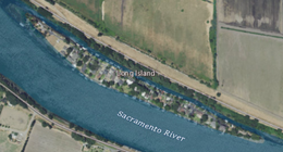 USGS aerial imagery of Long Island in the w:Sacramento River; to the south is w:Brannan Island, and to the north a bridge connects to Grand Island. | |
 Long Island  Long Island  Long Island | |
| Geography | |
|---|---|
| Location | Northern California |
| Coordinates | 38°10′01″N 121°37′30″W[1] |
| Adjacent bodies of water | Sacramento–San Joaquin River Delta |
| Highest elevation | 7 ft (2.1 m)[1] |
| Administration | |
United States | |
| State | |
| County | Sacramento |
References
- U.S. Geological Survey Geographic Names Information System: Long Island
- "Sacramento County Project and Policy Planning Commissions". The Sacramento Bee. Sacramento, California. 1977-07-07. p. 27.
- "Delta dikes stand against tides". Oakland Tribune. Oakland, California. 1980-01-18. p. 12.
- United States Geological Survey (1978). "Rio Vista Quadrangle, California" (Map). United States Department of the Interior Geological Survey. 1:24000.
- United States Geological Survey (1978). "Isleton Quadrangle, California" (Map). United States Department of the Interior Geological Survey. 1:24000.
Map: Islands of Suisun Bay and the Sacramento–San Joaquin River Delta | |
|---|---|
 Rough and Ready (islands of the San Francisco Bay Area) |
San Francisco Bay watershed | ||
|---|---|---|
| Outline |
|  |
| Subdivisions |
| |
| Waterways |
| |
| Parks and protected areas |
| |
| Islands and peninsulas |
| |
| Wetlands |
| |
| Bridges and tubes |
| |
| Ferries |
| |
| Ports and marinas |
| |
| Other |
| |
| ||
This Sacramento County, California-related article is a stub. You can help Wikipedia by expanding it. |
Текст в блоке "Читать" взят с сайта "Википедия" и доступен по лицензии Creative Commons Attribution-ShareAlike; в отдельных случаях могут действовать дополнительные условия.
Другой контент может иметь иную лицензию. Перед использованием материалов сайта WikiSort.org внимательно изучите правила лицензирования конкретных элементов наполнения сайта.
Другой контент может иметь иную лицензию. Перед использованием материалов сайта WikiSort.org внимательно изучите правила лицензирования конкретных элементов наполнения сайта.
2019-2026
WikiSort.org - проект по пересортировке и дополнению контента Википедии
WikiSort.org - проект по пересортировке и дополнению контента Википедии