geo.wikisort.org - Island Ryer Island is an island in the Sacramento-San Joaquin River Delta surrounded by Miner Slough and Steamboat Slough at their confluence with the Sacramento River , 6.5 miles north-northeast of Rio Vista .[1] [2] 4,750 ha (11,700-acre) island is named in honor of a California pioneer, Dr. Washington M. Ryer, and his family. A map prepared at the time of statehood shows the area divided by the west fork of the Sacramento River, with the western half identified as Priest Island and the eastern half identified as Sutter Island.[3]
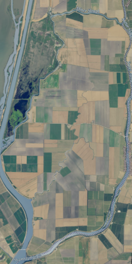
Ryer Island USGS aerial imagery of the island.
Show map of Sacramento-San Joaquin River Delta
Show map of the United States Location Northern California Coordinates 38.24357°N 121.63101°W / 38.24357; -121.63101 Adjacent bodies of water Sacramento-San Joaquin River Delta Area 11,700 acres (4,700 ha) United States
State California County Solano
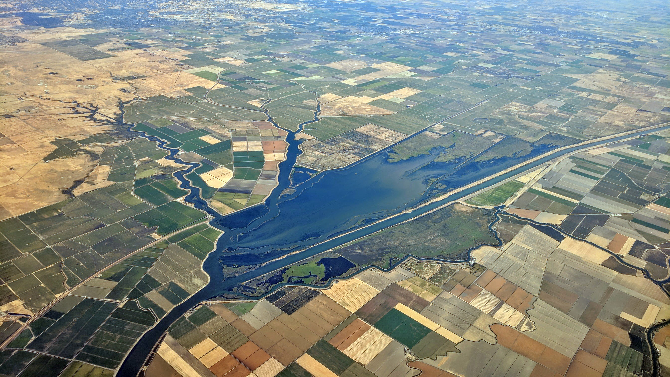
An aerial photo looking northwest, taken in 2018. Ryer Island can be seen on the bottom. The California Department of Transportation (Caltrans) operates two vehicle ferry services to the island, connecting the following state highways:[4]
SR 84 south / Ryer Island Ferry , towards Rio Vista SR 220 east / Howard Landing Ferry , towards Ryde Highway 220 then terminates at Highway 84 on Ryer Island, while the latter leaves the island north on a bridge, and towards West Sacramento .
See also
References
David L. Durham, California's Geographic Names: A Gazetteer of Historic and Modern Names of This State . p. 693. Quill Driver Books. (1998) ISBN 1-884995-14-4. "Municipal Service Review: Solano County Water, Irrigation, Reclamation, and Flood Management Agencies" (PDF) . Solano County LAFCO . Michael Brandman Associates. 13 April 2009. Retrieved 25 February 2021 . Ringgold, Cadwalader; Stuart, Fred D.; Everett, Chas.; Harrison (1850). "General Chart embracing Surveys of the Farallones Entrance to the Bay of San Francisco, Bays of San Francisco and San Pablo, Straits of Carquines and Suisun Bay, and the Sacramento and San Joaquin Rivers, to the Cities of Sacramento and San Joaquin, California" . David Rumsey Map Collection . San Francisco Common Council. Retrieved 25 February 2021 . "Special Route Restrictions" . Caltrans. Retrieved 2016-06-17 . External links
(islands of
Outline Subdivisions Waterways Parks and
Don Edwards National Wildlife Refuge
San Pablo Bay National Wildlife Refuge Eden Landing Ecological Reserve
Hayward Regional Shoreline
Hayward Shoreline Interpretive Center
Crown Memorial State Beach
McLaughlin Eastshore State Park
Emeryville Crescent State Marine Reserve
Point Isabel Regional Shoreline
César Chávez Park
Brooks Island Regional Preserve Point Pinole Regional Shoreline
Antioch Dunes National Wildlife Refuge
Coyote Point Recreation Area
Middle Harbor Shoreline Park
National Estuarine Research Reserve China Camp State Park
San Francisco Maritime National Historical Park
SF Bay Trail
Oyster Bay Regional Shoreline
Big Break Regional Shoreline
Palo Alto Baylands Nature Preserve Islands and Wetlands
Baylands
Belmont Chelsea
Cordelia Crissy Field Hoffman
Meeker
Mowry
Napa Sonoma
Point Molate
Salt ponds
Seal
Stege
Steinberger Suisun
Westpoint Bridges
Bridges San Francisco–Oakland
Eastern span replacement
Richmond–San Rafael
San Mateo–Hayward
Dumbarton
Dumbarton Rail Bridge (inactive) Golden Gate
Benicia–Martinez
Antioch
Carquinez
Leimert
Park Street
Fruitvale
High Street
Bay Farm Island
Tubes Posey/Webster Street
Transbay Ferries
Angel Island–Tiburon Ferry
Blue & Gold Fleet
Golden Gate Ferry
San Francisco Bay Ferry (WETA) Ports and
Port of San Francisco
Port of Oakland
Port of Richmond
Hunters Point Naval Shipyard
Mare Island Naval Shipyard
Port of Redwood City
Berkeley Marina Oyster Point Marina/Park
Westpoint Harbor
Foster City Marina (proposed) Other
History Delta and Dawn
Discovery Site
Humphrey the Whale
San Leandro Oyster Beds
Richmond Shipyards
U.S. Army Corps of Engineers Bay Model
Harold Gilliam
Marincello
Ecology Golden Gate Biosphere Reserve
Cosco Busan oil spill
Thicktail chub
Delta smelt
Conservation and Development Commission
The Watershed Project
Save The Bay
Citizens for East Shore Parks
Friends of Five Creeks
Urban Creeks Council
1971 oil spill
Greenbelt Alliance
The Bay Institute
Reber Plan
San Francisco Baykeeper
San Francisco Estuary and Watershed Science Estuary Partnership
Transportation Ridgway's rail/California clapper rail
Water Trail
Transportation in the San Francisco Bay Area
Counties Cities and towns Islands Waterways
Rivers, creeks
American River Beaver Slough Broad Slough Cache Slough Calaveras River Connection Slough Disappointment Slough Dutch Slough
Elk Slough False River
Fourteenmile Slough French Camp Slough Georgiana Slough
Hog Slough Indian Slough
Latnam Slough Lindsey Slough Lookout Slough Marsh Creek Mayberry Slough Middle River
Miner Slough Mokelumne River
New York Slough Old River Potato Slough Prospect Slough Sacramento River San Joaquin River Sand Mound Slough Sevenmile Slough Shag Slough Snodgrass Slough Steamboat Slough
Stockton Channel Sycamore Slough Taylor Slough
Rock Slough Threemile Slough Tom Paine Slough Trapper Slough Whiskey Slough White Slough Man-made
Bishop Cut Columbia Cut Delta Cross Channel
Fishermans Cut Hastings Cut Holland Cut Honker Cut North Victoria Canal Paradise Cut Sacramento River Deep Water Ship Channel
Stockton Deepwater Shipping Channel Victoria Canal Woodward Canal
Other features Water supply
Banks Pumping Plant
C.W. Bill Jones Pumping Plant
California Aqueduct
Clifton Court Forebay Contra Costa Canal
Delta-Mendota Canal
Mokelumne Aqueduct
South Bay Aqueduct
Peripheral Canal Bay Delta Conservation Plan Designated areas
Big Break Regional Shoreline
Brannan Island State Recreation Area
Franks Tract State Recreation Area
Sherman Island Waterfowl Management Area Stone Lakes National Wildlife Refuge
Woodbridge Ecological Reserve
Текст в блоке "Читать" взят с сайта "Википедия" и доступен по лицензии Creative Commons Attribution-ShareAlike ; в отдельных случаях могут действовать дополнительные условия. 2019-2025