geo.wikisort.org - Island
The Atlas Tract (formerly known as the Hartland Tract)[3] is an island in the Sacramento–San Joaquin River Delta, in San Joaquin County, California. It has been used for agriculture since it was first reclaimed in the late 19th century.
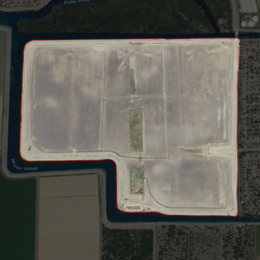 USGS aerial imagery of the Atlas Tract | |
 Atlas Tract  Atlas Tract  Atlas Tract | |
| Geography | |
|---|---|
| Location | Northern California |
| Coordinates | 38°02′09″N 121°22′58″W[1] |
| Adjacent bodies of water | Sacramento–San Joaquin River Delta |
| Area | 360 acres (150 ha)[2]: 325 |
| Highest elevation | 0 ft (0 m)[1] |
| Administration | |
United States | |
| State | |
| County | San Joaquin |
Geography
The Atlas Tract's boundaries are coterminous with Reclamation District 2126[4] (which was formed in 1989);[2]: 325 they are located entirely within the city of Stockton.[2]: 402 The Atlas Tract is rectangular, except for a small rectangular cutout in the southwest corner. The surface is flat, without significant change in elevation; the United States Geological Survey measured its overall elevation as 0 ft (0 m) in 1981.[1] It is mostly planted with crops, and is surrounded by 3.08 miles (5.0 km) of levees.[2]: 402 Its coordinates are 38°02′09″N 121°22′58″W[1]. It has a Mediterranean climate.[5]
To the north of the Atlas Tract lies the Bishop Tract, from which it is separated by Bear Creek and Pixley Slough.[6][7] To its west and south, across Mosher Slough, is the Shima Tract; to its east is Interstate 5.[6]
History
In the 1880s, the Atlas Tract was first developed and planted by Charles E. Knapp, a real estate investor and employee of the Southern Pacific company.[8] At the time, its largest landowners were Judge Cooney and Dr. S. F. Long, of San Francisco.[8] By 1915, livestock were being raised on the tract by M. Goldstein;[9] in 1935, the tract was still used for ranching and was the location of the Biaga ranch.[10]
In 1967, the First Stockton Corporation proposed to develop a man-made marina and lake there; the Stockton Planning Commission endorsed this proposal, but the county of San Joaquin had delayed approval of excavation permits.[11] The marina and park were to be constructed by removing 4,350,000 cubic yards (3,330,000 m3) of material, to be used for nearby freeway construction.[3] In December, it was announced that county officials had approved the plan, which was expected to be completed around 1970.[12] However, no such developments are shown in topographic maps from 1978,[13] 1993,[14] 1997,[6] or 2015.[15] In 2006, the Atlas Tract was aerially sprayed to kill mosquitoes suspected of carrying the West Nile virus.[16]
As of 2017, the Atlas Tract was owned by the Alex and Faye Spanos Family Trust, and used solely for agriculture (being used to grow small grains and hay).[2]: 325, 340 At that time, there were no residences on the land, but a large-scale residential development had been proposed on the tract (with potentially as many as 1,400 lots).[2]: 402 In 2015, the population was 0; the San Joaquin County Local Agency Formation Commission projected a population of 42,000 by 2045.[2]: 340
References
- U.S. Geological Survey Geographic Names Information System: Atlas Tract
- "Municipal Service Review: Selected San Joaquin County Reclamation Districts" (PDF). San Joaquin Local Agency Formation Commission. E Mulberg & Associates. 18 March 2018. Archived (PDF) from the original on 14 March 2021. Retrieved 24 February 2021.
- "Big Excavation Permit Sought". Tracy Press. Tracy, California. 1967-11-01. p. 13.
- "Reclamation Districts Map" (PDF). San Joaquin County Geographic Information Systems. San Joaquin County. 16 September 2020. Archived (PDF) from the original on 24 November 2020. Retrieved 24 February 2021.
- Peel, M C; Finlayson, B L. "Updated world map of the Köppen-Geiger climate classification". Hydrology and Earth System Sciences. 11: 1633–1644. doi:10.5194/hess-11-1633-2007. Retrieved 2022-01-21.
- United States Geological Survey (1997). "Terminous Quadrangle, California" (Map). United States Department of the Interior Geological Survey. 1:24000.
- United States Geological Survey (1952). "Terminous Quadrangle, California" (Map). United States Department of the Interior Geological Survey. 1:24000.
- "New Yorker Recalls Pioneer Land Deals". The Fresno Morning Republican. Fresno, California. 1912-04-29. p. 3.
- "Mortgages". Stockton Daily Evening Record. Stockton, California. 1915-03-18. p. 9.
- "Axe Killing Results From Delta Sport". Stockton Independent. Stockton, California. 1935-03-19. p. 2.
- "County Zoners Will Decide On Stockton Marina". The Sacramento Bee. Sacramento, California. 1967-10-30. p. 22.
- "SJ Approves Plan Creating 275-Acre Lake". The Modesto Bee. Modesto, California. 1967-12-01. p. 19. Retrieved 2021-11-17 – via Newspapers.com.
- United States Geological Survey (1978). "Terminous Quadrangle, California" (Map). United States Department of the Interior Geological Survey. 1:24000.
- United States Geological Survey (1993). "Lodi, California" (Map). United States Department of the Interior Geological Survey. 1:100000.
- United States Geological Survey (2015). "Terminous Quadrangle, California" (Map). United States Department of the Interior Geological Survey: US Topo. 1:24000.
- "Virus". The Escalon Times. Escalon, California. 2006-08-02. p. 10.
Map: Islands of Suisun Bay and the Sacramento–San Joaquin River Delta | |
|---|---|
 Rough and Ready (islands of the San Francisco Bay Area) |
San Francisco Bay watershed | ||
|---|---|---|
| Outline |
|  |
| Subdivisions |
| |
| Waterways |
| |
| Parks and protected areas |
| |
| Islands and peninsulas |
| |
| Wetlands |
| |
| Bridges and tubes |
| |
| Ferries |
| |
| Ports and marinas |
| |
| Other |
| |
| ||
Другой контент может иметь иную лицензию. Перед использованием материалов сайта WikiSort.org внимательно изучите правила лицензирования конкретных элементов наполнения сайта.
WikiSort.org - проект по пересортировке и дополнению контента Википедии