geo.wikisort.org - Mountains
Mount Meron (Hebrew: הַר מֵירוֹן, Har Meron; Arabic: جبل الجرمق, Jabal al-Jarmaq)[1] is a mountain in the Upper Galilee region of Israel. It has special significance in Jewish religious tradition and parts of it have been declared a nature reserve. At 1,208 metres (3,963 ft) above sea level, Mount Meron is the highest peak in Israel within the Green Line,[2] though many peaks in the Golan Heights and Mount Hermon, which was annexed by Israel in 1981, are higher.
| Mount Meron | |
|---|---|
| Har Merón • Jábal al-Jármaq הַר מֵירוֹן • جبل الجرمق | |
 Northern slopes of Mount Meron | |
| Highest point | |
| Elevation | 1,208 m (3,963 ft) |
| Coordinates | 32°59′52″N 35°24′49″E |
| Geography | |
 Mount Meron Israel  Mount Meron Mount Meron (Northeast Israel) | |
Mount Meron nature reserve
In 1965, an 84000-dunam nature reserve was declared. An additional 1199 dunams were declared part of the reserve in 2005.[3] It is the highest reserve in Israel, at an altitude of 1208 meters above sea level, and the largest reserve in the north of the country.[4]
Religious significance
This section does not cite any sources. (May 2021) |
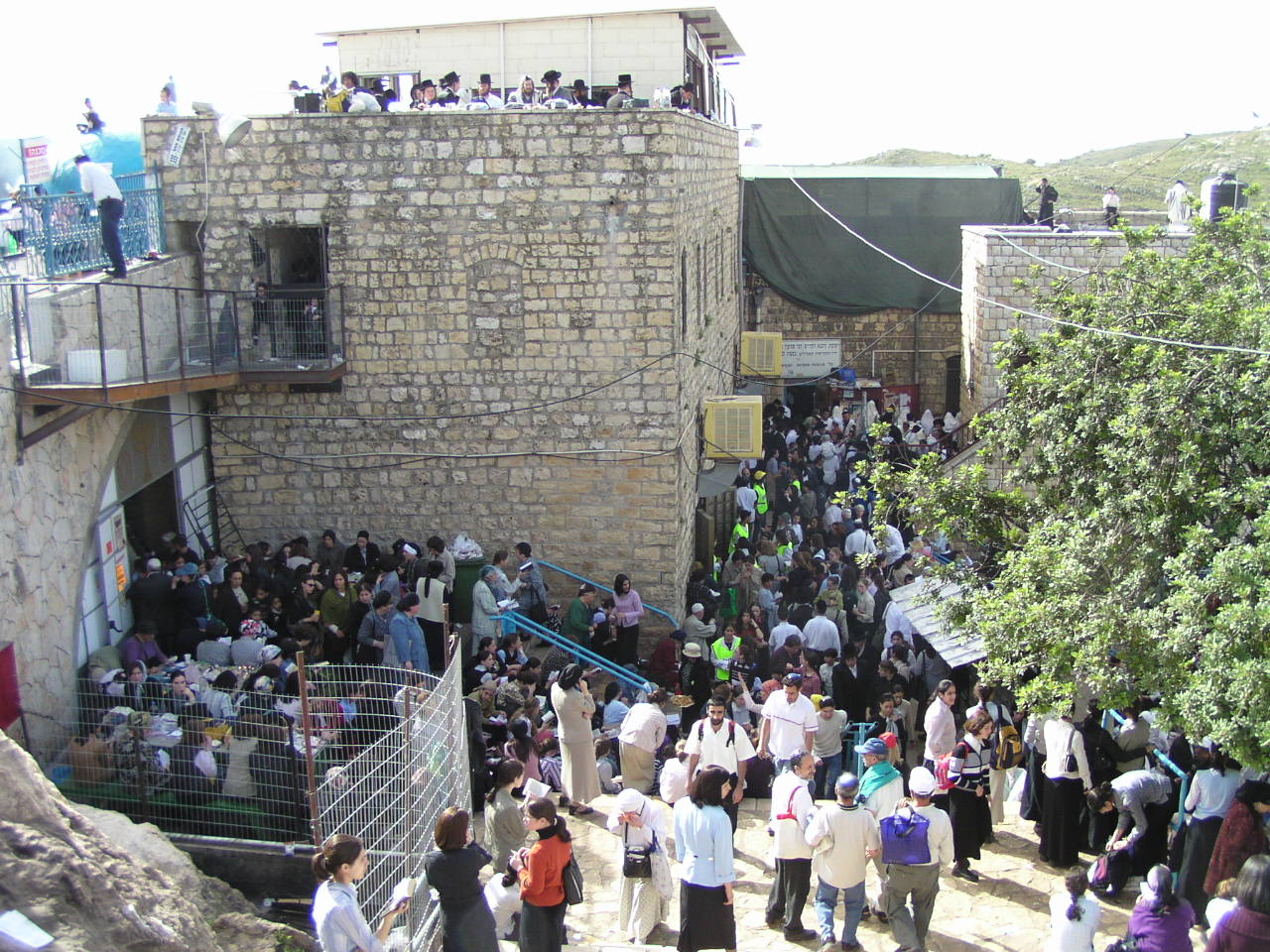
The village of Meron and the tomb of Rabbi Shimon bar Yochai are on Mount Meron. Leading up to the anniversary of his death on Lag BaOmer, thousands of people camp out along the slopes near the tomb, and on Lag B'Omer itself, hundreds of thousands make pilgrimages to celebrate the occasion.
Hiking paths
This section does not cite any sources. (May 2021) |
The mountain has extensive undergrowth and cannot be climbed from every direction. The main path starts at the northwest side of the Meron village. There is a gate next to the road, with a color-marked path of about 10 km. There is also a path on the west side of the mountain.
Climate
This section does not cite any sources. (May 2021) |

Mount Meron has a Mediterranean climate (Köppen climate classification: Csa) with hot and dry summers and cool, wet and occasionally snowy winters. It snows briefly on Mount Meron a few times during every winter. There are 22 days a year with a temperature of 32 °C or higher and 28 days below freezing. Mount Meron has the second highest precipitation in Israel after Mount Hermon. Note: the chart is an average of 5 years so the record highs and lows may not be fully accurate.
| Climate data for Mount Meron (2002–2007) | |||||||||||||
|---|---|---|---|---|---|---|---|---|---|---|---|---|---|
| Month | Jan | Feb | Mar | Apr | May | Jun | Jul | Aug | Sep | Oct | Nov | Dec | Year |
| Record high °C (°F) | 17 (63) |
22 (72) |
18 (64) |
26 (79) |
32 (90) |
32 (90) |
33 (91) |
36 (97) |
33 (91) |
28 (82) |
26 (79) |
20 (68) |
36 (97) |
| Average high °C (°F) | 8 (46) |
9 (48) |
11 (52) |
18 (64) |
23 (73) |
27 (81) |
29 (84) |
30 (86) |
27 (81) |
26 (79) |
20 (68) |
12 (54) |
20 (68) |
| Daily mean °C (°F) | 6 (43) |
6 (43) |
7 (45) |
13 (55) |
18 (64) |
21 (70) |
23 (73) |
24 (75) |
21 (70) |
20 (68) |
16 (61) |
9 (48) |
15 (59) |
| Average low °C (°F) | 4 (39) |
3 (37) |
4 (39) |
8 (46) |
13 (55) |
15 (59) |
17 (63) |
18 (64) |
16 (61) |
15 (59) |
12 (54) |
6 (43) |
11 (52) |
| Record low °C (°F) | −2 (28) |
−8 (18) |
— | 3 (37) |
7 (45) |
11 (52) |
15 (59) |
13 (55) |
13 (55) |
11 (52) |
5 (41) |
— | −8 (18) |
| Average precipitation mm (inches) | 70 (2.8) |
190 (7.5) |
270 (10.6) |
60 (2.4) |
80 (3.1) |
180 (7.1) |
— | — | — | — | 20 (0.8) |
240 (9.4) |
1,150 (45.3) |
| Average precipitation days | 5 | 10 | 8 | 4 | 5 | 10 | — | — | — | — | 1 | 10 | 56 |
| Average relative humidity (%) | 75 | 72 | 68 | 55 | 45 | 45 | 46 | 49 | 52 | 50 | 56 | 72 | 57 |
| Source: "Climate Information for Har Meron, Israel". Weather Base. | |||||||||||||
Incidents
On May 17, 1911, the collapse of an eight-meter high roof caused 40 wounded and seven fatalities.[5] As the nearby hospital was closed, people from the surrounding area donated bedsheets and equipment to assist the wounded.[6]
At about 12:50 a.m. on April 30, 2021, hundreds of Israelis were trampled as they were leaving the mountain, having attended a Lag BaOmer celebration that drew an estimated 100,000 people in spite of a 10,000-people limit imposed due to the COVID-19 pandemic. At least 45 people died in the disaster, with hundreds injured.[7]
References
- "Encyclopædia Britannica: Mount Meron". Retrieved 2008-11-24.
- Federal Research Division (2004). Israel A Country Study (Paperback ed.). Kessinger Publishing, LLC. p. 8. ISBN 141912689X.
- "List of National Parks and Nature Reserves" (PDF) (in Hebrew). Israel Nature and Parks Authority. Archived from the original (PDF) on 2009-10-07. Retrieved 2010-09-27.
- "Mount Meron reserve" (in Hebrew). Israel Nature and Parks Authority. Archived from the original on 2011-09-28. Retrieved 2010-09-27.
- גלילי, זאב (May 9, 2017). "ל"ג בעומר 1911 – האסון שזעזע את ארץ ישראל".
- "לג בעומר, מירון 1911: הילולה שהפכה ליללה". www.news1.co.il.
- "44 crushed to death, over 150 hurt in stampede at mass Lag B'Omer event in Meron". Times of Israel. 30 April 2021. Retrieved 2021-04-30.
Authority control | |
|---|---|
| General |
|
| National libraries | |
| Other | |
На других языках
[de] Har Meron
Der Berg Meron (hebräisch .mw-parser-output .Hebr{font-size:115%}הר מירון .mw-parser-output .Latn{font-family:"Akzidenz Grotesk","Arial","Avant Garde Gothic","Calibri","Futura","Geneva","Gill Sans","Helvetica","Lucida Grande","Lucida Sans Unicode","Lucida Grande","Stone Sans","Tahoma","Trebuchet","Univers","Verdana"}Har Meron; arabisch جبل الجرمق Dschabal al-Dscharmaq) liegt in Israel 1208 m über dem Meeresspiegel. Er ist der höchste Berg innerhalb der international anerkannten Grenzen des Staates. Der Meron ist Israels zweithöchster Berg, falls man die besetzten Golanhöhen, die teilweise den Har Hermon umfassen, mit einbezieht.- [en] Mount Meron
[fr] Mont Méron
Le mont Méron (en hébreu : הר מירון, Har Meron ; en arabe : جبل الجرمق, Djabal al-Djarmaq) est avec 1 208 m d'altitude le point culminant d'Israël hors le Golan ; il est situé en Galilée. Il abrite l'une des plus grandes et la plus élevée des réserves naturelles du pays, traversée par le Sentier national israélien.[it] Monte Meron
Il monte Meron, o Har Meron, è, con i suoi 1.208 m s.l.m., il punto più elevato di Israele; è situato in Galilea. È sede di una delle maggiori riserve naturali del paese, attraversata dal sentiero nazionale d'Israele.[ru] Мерон
Гора Мерон (Мирон, ивр. הר מירון, Har Meron; араб. جبل الجرمق, Jabal Al-Jarmaq) — самая высокая гора в Галилее (Израиль).Другой контент может иметь иную лицензию. Перед использованием материалов сайта WikiSort.org внимательно изучите правила лицензирования конкретных элементов наполнения сайта.
WikiSort.org - проект по пересортировке и дополнению контента Википедии