geo.wikisort.org - Mountains
Mount Carmel (Hebrew: הַר הַכַּרְמֶל, romanized: Har haKarmel; Arabic: جبل الكرمل, romanized: Jabal al-Karmil), also known in Arabic as Mount Mar Elias (Arabic: جبل مار إلياس, romanized: Jabal Mār Ilyās, lit. 'Mount Saint Elias/Elijah'), is a coastal mountain range in northern Israel stretching from the Mediterranean Sea towards the southeast. The range is a UNESCO biosphere reserve. A number of towns are situated there, most notably the city of Haifa, Israel's third largest city, located on the northern and western slopes.
| Mount Carmel | |
|---|---|
| הר הכרמל (Hebrew) جبل الكرمل / جبل مار إلياس (Arabic) | |
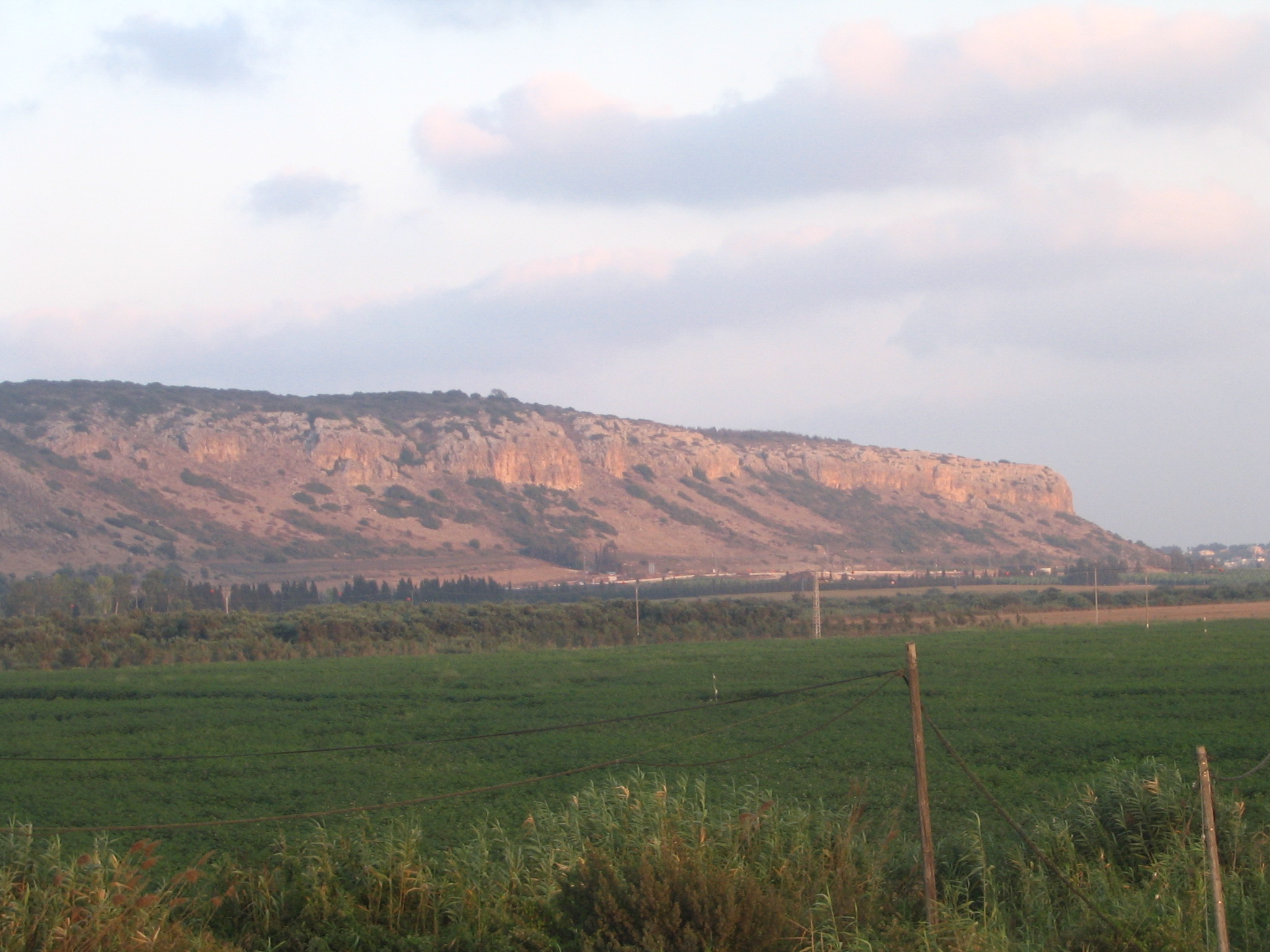 Southern tip of Mount Carmel at sunset, as seen from the entrance to Kibbutz Ma'agan Michael | |
| Highest point | |
| Elevation | 525.4 m (1,724 ft) |
| Dimensions | |
| Length | 39 km (24 mi) |
| Width | 8 km (5.0 mi) |
| Geography | |
 | |
| Country | Israel |
| District | Haifa |
| Range coordinates | 32°44′N 35°03′E |
| Geology | |
| Type of rock | Limestone and flint |

Etymology
The word karmel means "garden-land"[1] and is of uncertain origin. It is either a compound of kerem and el, meaning "vineyard of God" or a clipping of kar male, meaning "full kernel."[2] Martin Jan Mulder suggested a third etymology, that of kerem + l with the lamed a sufformative, but this is considered unlikely as evidence for the existence of a lamed sufformative is weak.[3]
Geography and geology
The phrase "Mount Carmel" has been used in three distinct ways, referring to either one of the following three areas:[4]
- The 39 km (24 mi) long mountain range all the way to Jenin, including the Manasseh Hill Country and the heights southeast of it.
- The northwestern 21 km (13 mi) of the mountain range.
- The headland at the northwestern end of the range.
The Carmel range is approximately 6.5 to 8 kilometres (4.0 to 5.0 miles) wide, sloping gradually towards the southwest, but forming a steep ridge on the northeastern face, 546 metres (1,791 feet) high. The Jezreel Valley lies to the immediate northeast. The range forms a natural barrier in the landscape, just as the Jezreel Valley forms a natural passageway, and consequently the mountain range and the valley have had a large impact on migration and invasions through the Levant over time.[4]
The mountain formation is an admixture of limestone and flint, containing many caves, and covered in several volcanic rocks.[4][5]
The sloped side of the mountain is covered with luxuriant vegetation, including oak, pine, olive, and laurel trees.[5]
Several modern towns are located on the range, including Yokneam on the eastern ridge; Zikhron Ya'akov on the southern slope; the Druze communities of Daliyat al-Karmel and Isfiya on the more central part of the ridge; and the towns of Nesher, Tirat Hakarmel, and the city of Haifa, on the far northwestern promontory and its base. There is also a small kibbutz called Beit Oren, which is located on one of the highest points in the range to the southeast of Haifa.
History
Palaeolithic and Epipalaeolithic

As part of a 1929–1934 campaign,[6] between 1930 and 1932, Dorothy Garrod excavated four caves, and a number of rock shelters, in the Carmel mountain range at el-Wad, el-Tabun, and Es Skhul.[7] Garrod discovered Neanderthal and early modern human remains, including the skeleton of a Neanderthal female, named Tabun I, which is regarded as one of the most important human fossils ever found.[8] The excavation at el-Tabun produced the longest stratigraphic record in the region, spanning 600,000 or more years of human activity.[9] The four caves and rock-shelters (Tabun, Jamal, el-Wad, and Skhul) together yield results from the Lower Paleolithic to the present day, representing roughly a million years of human evolution.[10] There are also several well-preserved burials of Neanderthals and Homo sapiens and the transition from nomadic hunter-gatherer groups to complex, sedentary agricultural societies is extensively documented at the site. Taken together, these emphasize the paramount significance of the Mount Carmel caves for the study of human cultural and biological evolution within the framework of palaeo-ecological changes."[11]
In 2012, UNESCO's World Heritage Committee added the sites of human evolution at Mount Carmel to the List of World Heritage Sites.[12][13][14] The World Heritage Site includes four caves (Tabun, Jamal, el-Wad, and Skhul) on the southern side of the Nahal Me'arot/Wadi El-Mughara Valley. The site fulfils criteria in two separate categories, "natural" and "cultural".[13]
Of great interest for the Near East Epipalaeolithic is Kebara Cave.

In December 2020, archaeologists from the University of Haifa announced the discovery of the oldest known tool used for grinding or scraping, dating back about 350,000 years at the Tabun Cave at Mount Carmel site. According to researchers, this cobble belongs to the Acheulo-Yabrudian complex from the late Lower Paleolithic and was used by hominids for abrading surfaces.[15][16][17][18]
Ancient agriculture: olive oil and wine
Archaeologists have discovered ancient wine and oil presses at various locations on Mount Carmel.[4][5]
As a strategic location
Hebrew Bible
Due to the lush vegetation on the sloped hillside, and many caves on the steeper side, Carmel became the haunt of criminals;[4] Thickly-wooded Carmel was seen as a hiding place, as implied by the Book of Amos.[4][19] According to the Books of Kings, Elisha travelled to Carmel straight after cursing a group of young men because they had mocked him and the ascension of Elijah by jeering, "Go on up, bald man!" After this, bears came out of the forest and mauled 42 of them.[20] This does not necessarily imply that Elisha had sought asylum there from any potential backlash,[4] although the description in the Book of Amos, of the location being a refuge, is dated by textual scholars to be earlier than the accounts of Elisha in the Books of Kings.[21][22]
Roman and Byzantine periods
According to Strabo, Mount Carmel continued to be a place of refuge until at least the first century.[23]
According to Josephus[24] and Epiphanius,[25] Mount Carmel had been the stronghold of the Essenes that came from Nazareth; this Essene group are sometimes referred to as Nazareans, possibly akin to the Nazarenes, which followed the teachings of Jesus.[26]
World War I
During World War I, Mount Carmel played a significant strategic role. The Battle of Megiddo took place at the head of a pass through the Carmel Ridge, which overlooks the Valley of Jezreel from the south. General Allenby led the British in the battle, which was a turning point in the war against the Ottoman Empire. The Jezreel Valley had played host to many battles before, including the very historically significant Battle of Megiddo between the Egyptians and Canaanites in the 15th century BCE, but it was only in the 20th-century battle that the Carmel Ridge itself played a significant part, due to the development in artillery and munitions.[citation needed]
As a sacred location
Canaanites
In ancient Canaanite culture, high places were frequently considered to be sacred, and Mount Carmel appears to have been no exception; Egyptian pharaoh Thutmose III lists a holy headland among his Canaanite territories, and if this equates to Carmel, as Egyptologists such as Maspero believe, then it would indicate that the mountain headland was considered sacred from at least the 15th century BCE.[4]
Israelites and Hebrew Bible
Altar to God
According to the Books of Kings, there was an altar to God on the mountain, which had fallen into ruin by the time of Ahab, but Elijah built a new one (1 Kings 18:30–32).
Elijah
In mainstream Jewish, Christian, and Islamic[4] thought, Elijah is indelibly associated with the mountain, and he is regarded as having sometimes resided in a grotto on the mountain. Indeed, one Arabic name for Mount Carmel is جبل مار إلياس (Jabal Mar Elyas, lit. "Mount of Saint Elias"). In the Books of Kings, Elijah challenges 450 prophets of Baal to a contest at the altar on Mount Carmel to determine whose deity was genuinely in control of the Kingdom of Israel. As the narrative is set during the rule of Ahab and his association with the Phoenicians, biblical scholars suspect that the Baal in question was probably Melqart.[27]
According to chapter 18 of the Books of Kings in the Hebrew Bible, the challenge was to see which deity could light a sacrifice by fire. After the prophets of Baal had failed, Elijah had water poured upon his sacrifice to saturate the altar. He then prayed. Fire fell and consumed the sacrifice, wood, stones, soil and water, which prompted the Israelite witnesses to proclaim, "The LORD, He is God! The LORD, He is God!" In the account, Elijah also announced the end to a long three-year drought, which had previously been sent as divine punishment for Israel's idolatry.
Though there is no biblical reason to assume that the account of Elijah's victory refers to any particular part of Mount Carmel,[4] Islamic tradition places it at a point known as El-Maharrakah or rather El-Muhraqa, meaning the burning.[5]
Two areas have been hypothesized as the possible site for the story about the battle against the priests of Baal. The slaughter could have taken place near the river Kishon, at the mountain base, in an amphitheater-like flat area. The site where the offering took place is traditionally placed on the mountain above Yokneam, on the road to the Druze village of Daliyat el-Karmil, where there is a monastery, built in 1868, called El-Muhraqa ("the burning", possibly related to the burnt sacrifice"). It is regarded as one of the must-visit tour sites in the area of Haifa.[28] (See below under "Carmelites (12th c.–present): El-Muhraqa site" for more).
Although archaeological clues are absent, the site is favoured because it has a spring, from which water could have been drawn to wet Elijah's offering. There is also a sea view, where Elijah looked out to see the cloud announcing rain. However, the biblical text states that Elijah had to climb up to see the sea. There is an altar in the monastery which is claimed to be that which Elijah built in God's honour, but that is unlikely, as it's not made of the local limestone.[29]
Druze venerate Elijah, and he is considered a central figure in Druzism,[30] and due to his importance in Druzism, the settlement of Druze on Mount Carmel had partly to do with Elijah's story and devotion. There are two large Druze towns on the eastern slopes of Mount Carmel: Daliyat al-Karmel and Isfiya.[30]
Hellenistic and Roman periods
Iamblichus describes Pythagoras visiting the mountain on account of its reputation for sacredness, stating that it was the most holy of all mountains, and access was forbidden to many, while Tacitus states that there was an oracle situated there, which Vespasian visited for a consultation;[5] Tacitus states that there was an altar there, but without any image upon it, and without a temple around it.[31]
The existence of a pagan temple on Mount Carmel is supported by the Periplus of Pseudo-Scylax, a fourth century periplus that mentions Mount Carmel as the "mount and temple of Zeus".[32]
Carmelites (12th century – present)

A Catholic religious order was founded on Mount Carmel in 1209, named the Carmelites, in reference to the mountain range; the founder of the Carmelites is still unknown (d.1265).[33] In the original Rule or 'Letter of Life' given by Albert, the Latin Patriarch of Jerusalem who was resident in Acre, around the year 1210, this hermit is referred to simply as 'Brother B'; he probably died around the date 1210 and could have been either a pilgrim, someone serving out a penance or a crusader who had stayed in the Holy Land.[citation needed]
Although Louis IX of France is sometimes named as the founder, he was not, and had merely visited it in 1252.[5]
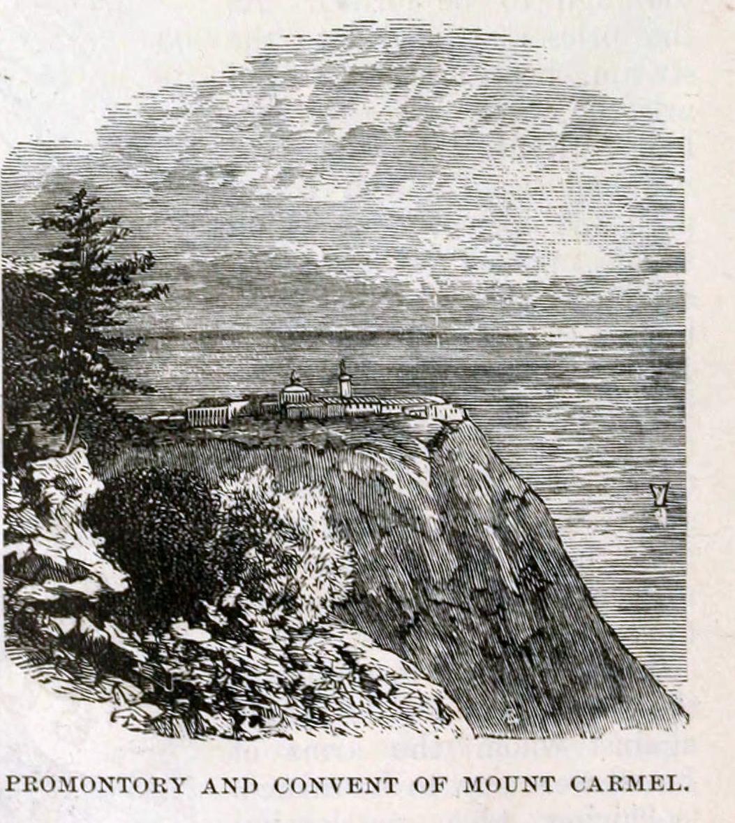
- Stella Maris site
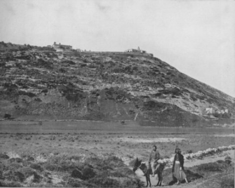
The Order was founded at the site that it claimed had been the location of Elijah's cave, 1,700 feet (520 m) above sea level at the northwestern end of the mountain range.[4]
Though there is no documentary evidence to support it, Carmelite tradition suggests that a community of Jewish hermits had lived at the site from the time of Elijah until the Carmelites were founded there; prefixed to the Carmelite Constitution of 1281 was the claim that from the time when Elijah and Elisha had dwelt devoutly on Mount Carmel, priests and prophets, Jewish and Christian, had lived "praiseworthy lives in holy penitence" adjacent to the site of the "fountain of Elisha"[dubious ] in an uninterrupted succession.[dubious ][citation needed]
A Carmelite monastery was founded at the site shortly after the Order itself was created, and was dedicated to the Blessed Virgin Mary under the title of "Star of the Sea" ("stella maris" in Latin), a common medieval presentation of her.[4]
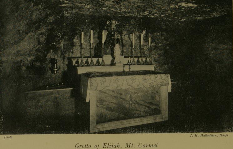
The Carmelite Order grew to be one of the major Catholic religious orders worldwide, although the monastery at Carmel has had a less successful history. During the Crusades the monastery often changed hands, frequently being converted into a mosque.[5] In 1799 the building was finally converted into a hospital, by Napoleon, but in 1821 the surviving structure was destroyed by the pasha of Damascus.[5] A new monastery was later constructed directly over a nearby cave, after funds were collected by the Carmelite Order for restoration of the monastery.[5] The cave, which now forms the crypt of the monastic church, is termed "Elijah's grotto" by the Discalced Carmelite friars who have custody of the monastery.[5]
- El-Muhraqa site

Under Islamic control the location at the highest peak of the Carmel came to be known as "El-Maharrakah" or "El-Muhraqa", meaning "place of burning", in reference to the account of Elijah's challenge to the priests of Hadad.[5] This, perhaps not coincidentally, is also the highest natural point of the mountain range.[citation needed]
- The Scapular of Our Lady of Mount Carmel
One of the oldest scapulars is associated with Mount Carmel and the Carmelites. According to Carmelite tradition, the Scapular of Our Lady of Mount Carmel was first given to St. Simon Stock, an English Carmelite, by the Blessed Virgin Mary. The Carmelites refer to her under the title "Our Lady of Mount Carmel," and celebrate 16 July as her feast day.[citation needed]
Baháʼí Faith

Mount Carmel is considered a sacred place for followers of the Baháʼí Faith, and is the location of the Baháʼí World Centre and the Shrine of the Báb. The location of the Baháʼí holy places has its roots in the imprisonment of the religion's founder, Bahá'u'lláh, near Haifa by the Ottoman Empire during the Ottoman Empire's rule over Palestine.
The Shrine of the Báb is a structure where the remains of the Báb, the founder of Bábism and forerunner of Bahá'u'lláh in the Baháʼí Faith, have been laid to rest. The shrine's precise location on Mount Carmel was designated by Bahá'u'lláh himself and the Báb's remains were laid to rest on March 21, 1909, in a six-room mausoleum made of local stone. The construction of the shrine with a golden dome was completed over the mausoleum in 1953,[34] and a series of decorative terraces around the shrine were completed in 2001. The white marbles used were from the same ancient source that most Athenian masterpieces were using, the Penteliko Mountain.
Bahá'u'lláh, the founder of the Baháʼí Faith, writing in the Tablet of Carmel, designated the area around the shrine as the location for the administrative headquarters of the religion; the Baháʼí administrative buildings were constructed adjacent to the decorative terraces, and are referred to as the Arc, on account of their physical arrangement.
Ahmadiyya Muslims
The Ahmadiyya Muslim Community has its largest Israeli mosque on Mount Carmel, in the Kababir quarter of Haifa, known as the Mahmood Mosque. It is a unique structure with two minarets.[35] The mosque was once visited by the president of Israel, Shimon Peres, for an iftar dinner.[36]
Gallery

See also
- Mount Carmel National Park
- Nahal Me'arot Nature Reserve
- Mount Carmel Forest Fire (2010)
- Sacred Heart Chapel, Haifa
- Palestine Final Fortress
References
- "Brown-Driver-Briggs Hebrew and English Lexicon".
- "Aviv Hadash: An Israeli youth encyclopedia for". p. vol. 9 pg. 169.
- Paul, Jouon; Tamitsu, Muraoka (2006). A Grammar of Biblical Hebrew. Gregorian Biblical BookShop. ISBN 978-88-7653-629-8.
- Cheyne and Black, Encyclopedia Biblica
- Jewish encyclopedia
- Callander, Jane (2004). "Garrod, Dorothy Annie Elizabeth (1892–1968)". Oxford Dictionary of National Biography (online ed.). Oxford University Press. doi:10.1093/ref:odnb/37443. Retrieved 2011-02-14. (Subscription or UK public library membership required.)
- "Timeline in the Understanding of Neanderthals". Archived from the original on 2007-09-27. Retrieved 2007-07-13.
- Christopher Stringer, custodian of Tabun I, Natural History Museum, quoted in an exhibition in honour of Garrod; Callander and Smith, 1998
- "From 'small, dark and alive' to 'cripplingly shy': Dorothy Garrod as the first woman Professor at Cambridge". Archived from the original on 2009-02-28. Retrieved 2007-07-13.
- "Excavations and Surveys / Prehistory Division". The Zinman Institute of Archaeology, University of Haifa. Retrieved 2016-04-18.
- "The Zinman Institute of Archaeology – Excavations and Surveys". Arch.haifa.ac.il. Archived from the original on March 13, 2013. Retrieved 2009-01-19.
{{cite web}}: CS1 maint: unfit URL (link) - "Newest UNESCO World Heritage Site-Carmel Caves" (Press release). Israel Ministry of Foreign Affairs. 2012-07-02. Retrieved 2016-04-19.
- Udasin, Sharon (2012-06-29). "4 Mount Carmel Caves Nominated to Join UNESCO". The Jerusalem Post. Retrieved 2016-04-19.
- "Twenty-six new sites inscribed on UNESCO World Heritage List this year" (Press release). UNESCO. 2012-07-02. Retrieved 2016-04-19.
- Winer, Stuart. "Stone found in Israel is oldest known tool in world used for 'delicate' abrading". www.timesofisrael.com. Retrieved 2021-06-26.
- "A 350,000-year-old turning point in human evolution found in Israel". Haaretz. Retrieved 2021-06-26.
- "The oldest known abrading tool was used around 350,000 years ago". Science News. 2021-01-21. Retrieved 2021-06-26.
- "357,000-Year-Old Abrading Tool Unearthed in Israel | Archaeology | Sci-News.com". Breaking Science News | Sci-News.com. Retrieved 2021-06-26.
- Amos 9:3
- 2 Kings 2:25
- Jewish Encyclopedia, Books of Kings
- Jewish Encyclopedia, Book of Amos
- Strabo, Geographica
- Josephus, War of the Jews
- Epiphanius of Salamis, Panarion 1:18
- J Gordon Melton, Encyclopedia of American Religions
- Peake's commentary on the Bible
- BI, Editor (2018-11-29). "Tour Haifa: 5 Must-Visit Sites in Haifa". Biz Israel.
{{cite web}}:|first=has generic name (help) - "Mount Carmel". The Jewish Magazine. Retrieved 2016-01-30.
- Swayd, Samy (2015). Historical Dictionary of the Druzes. Rowman & Littlefield. p. 77. ISBN 9781442246171.
- Tacitus Histories 2.78.
- Safrai, Ze'ev (2018). "Jewish and Christian Sacred Sites in the Holy Land". Seeking out the Land: Land of Israel Traditions in Ancient Jewish, Christian and Samaritan Literature (200 BCE - 400 CE). Boston: BRILL. ISBN 978-90-04-33482-3. OCLC 1045023033.
- James Hitchcock, History of the Catholic Church, San Francisco: Ignatius Press, 2012, p.155.
- "Golden anniversary of the Queen of Carmel". Baháʼí World News Service. 2003-10-12. Retrieved 2007-05-12.
- "Holy Sites in Haifa". Tour-Haifa. Retrieved 18 November 2010.
- "Shimon Peres visits Ahmadiyya Mosque in Kababir Israel". youtube. Retrieved 4 December 2010.[dead YouTube link]
External links
- UNESCO Biosphere Reserves Directory
- UNESCO World Heritage List
- Mount Carmel – BiblePlaces.com, pictures and text illuminating the biblical site
- Carmel Holy Land, the website of the Carmelite monastery at the traditional site of Elijah's confrontation with the priests of Baal
На других языках
[de] Karmel (Gebirge)
Der Karmel oder Carmel (hebräisch .mw-parser-output .Hebr{font-size:115%}כַּרְמֶל, abgeleitet von kerem 'el, „Weinberg Gottes“; arabisch جبل الكرمل Dschabal al-Karmil) ist ein Gebirge in Israel. Es ist 23 Kilometer lang und 8 bis 10 Kilometer breit und erhebt sich bis zu einer Höhe von 546 Metern entlang der Mittelmeerküste. Wegen der verhältnismäßig hohen Niederschläge hat das Gebirge eine üppige Vegetation und wurde zum Nationalpark erklärt.- [en] Mount Carmel
[es] Monte Carmelo
El Monte Carmelo (en hebreo, הר הכרמל Har HaCarmel; en árabe, جبل الكارمل Yabal al-Karmil) es una cordillera en Israel sobre el mar Mediterráneo. Tiene forma triangular, mide unos 26 km de largo y alrededor de 7 km de ancho y su altura máxima es de unos 550 m. Sus coordenadas son 32° 50' de latitud Norte y 35º de longitud Este. Su nombre significa «viñedos de Dios» (combinación de las palabras hebreas Karem y El), aunque existen otras teorías sobre el origen del nombre, todas en torno a la palabra Karem (viña), teniendo en cuenta que en la Antigüedad estaba cubierto por viñedos y fue famoso por su fertilidad. Gran parte de la ciudad de Haifa está situada sobre el Monte Carmelo, como también otras pequeñas ciudades como Nesher o Tirat Karmel, que forman parte del área metropolitana de Haifa. En la tradición cristiana, el lugar es conocido por la aparición de la Virgen del Carmen.[fr] Mont Carmel
Le mont Carmel, en hébreu הַר הַכַּרְמֶל, Har HaKarmel, littéralement en français « le vignoble de Dieu », est une montagne côtière d'Israël surplombant la mer Méditerranée. La ville de Haïfa se trouve en partie sur le flanc du mont Carmel, ainsi que quelques petites villes, comme Nesher ou Tirat Carmel.[it] Monte Carmelo
Il monte Carmelo (הַר הַכַּרְמֶל Har ha Karmell o anche Kerem-El, letteralmente «Vigna di Dio») è una catena montuosa lunga 39 km e larga 7 o 8 km, che si trova nell'Alta Galilea, una regione dello Stato di Israele. La catena si sviluppa in direzione nordovest-sudest da Haifa a Jenin ed è delimitata sul fianco NE dalla valle di Jezreel. Questo fianco è molto ripido, mentre quello SO digrada dolcemente. Tocca l'altezza massima di 525 m s.l.m.[ru] Кармель
Ка́рмель[2][3][4], также Карме́л[5], Карме́ль, Карми́л[6] (ивр. הכַּרְמֶל Ха-Карме́ль) — горный массив на северо-западе Израиля. Часто упоминается как гора Кармель или как горный хребет Кармель, в русской Библии названа горой Кармил[7]. С запада хребет ограничен Средиземным морем, с севера — Хайфским заливом и долиной Звулун. На юге и востоке хребет понемногу понижается, переходя в холмы в районе городов Биньямина на юге и Йокнеама на востоке (примерно 25 километров в каждую сторону). Впрочем, на востоке холмы быстро снова превращаются в горы, окружающие долину реки Иордан.Другой контент может иметь иную лицензию. Перед использованием материалов сайта WikiSort.org внимательно изучите правила лицензирования конкретных элементов наполнения сайта.
WikiSort.org - проект по пересортировке и дополнению контента Википедии