geo.wikisort.org - Mountains
The Judaean Mountains, or Judaean Hills (Hebrew: הרי יהודה, romanized: Harei Yehuda) or the Hebron Mountains (Arabic: تلال الخليل, romanized: Tilal al-Khalīl, lit. 'Hebron Mountains'), is a mountain range in Israel and the West Bank where Jerusalem, Hebron and several other biblical cities are located. The mountains reach a height of 1,026 metres (3,366 ft).[1] The Judean Mountains can be separated to a number of sub-regions, including the Mount Hebron ridge, the Jerusalem ridge and the Judean slopes.
| Judaean Mountains | |
|---|---|
| Harei Yehuda / Jibal Al Khalil | |
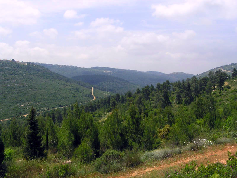 View of the Judaean Hills near Jerusalem | |
| Highest point | |
| Peak | Mount Halhul |
| Elevation | 1,026 m (3,366 ft)[1] |
| Coordinates | 31°40′N 35°10′E[2] |
| Geography | |
 Location | |
| Parent range | Great Rift Valley |
| Geology | |
| Age of rock | Late Cretaceous |
| Type of rock | Terra rossa, limestone |
| Climbing | |
| Easiest route | Road of the Patriarchs (the ridge route) |
The Judaean Mountains formed the heartland of the Kingdom of Judah (930-586 BCE), where the earliest Jewish settlements emerged, and from which Jews are generally descended.[3][4][5]
Geography
The Judaean mountains are part of a more extended range that runs in a north-south direction. The ridge consists of the Samarian Hills in its northern part, and of the Judaean mountains in its southern part, the two segments meeting at the latitude of Ramallah. The westward descent from the hard limestone country of the Judaean mountains towards the coastal plain is by way of a longitudinal trough of fosse cut through chalk, followed by the low, rolling soft limestone hills of the Shephelah, while eastwards the landscape falls steeply towards the Jordan Rift Valley. The southern end of the mountain range is at Beersheba[6][7][8] in the northern part of the Negev, where the mountains slope down into the Beersheba-Arad valley.[citation needed] The average height of the Judaean mountains is of 900 metres (2,953 ft), and they encompass the cities of Ramallah, Jerusalem, Bethlehem and Hebron.[citation needed] The northern section of the Judaean mountains is referred to as Jerusalem Hills, and the southern one as Hebron Hills.[citation needed]
The Judaean Mountains were heavily forested in antiquity. The range is mostly composed of terra rossa soils over hard limestones.[1][9]
Geology and palaeontology
The Judaean Mountains are the surface expression of a series of monoclinic folds which trend north-northwest through Israel. The folding is the central expression of the Syrian Arc belt of anticlinal folding that began in the Late Cretaceous Period in northeast Africa and southwest Asia. The Syrian Arc extends east-northeast across the Sinai, turns north-northeast through Israel and continues the east-northeast trend into Syria. The Israeli segment parallels the Dead Sea Transform which lies just to the east.[10][11] The uplift events that created the mountain occurred in two phases one in the Late Eocene-Early Oligocene and second in the Early Miocene.[12]
In prehistoric times, animals no longer found elsewhere in the Levant region were found here, including elephants, rhinoceroses, giraffes and wild Asian water buffalo.[13]
The range has karst topography including a stalactite cave in Nahal Sorek National Park between Jerusalem and Beit Shemesh and the area surrounding Ofra, where fossils of prehistoric flora and fauna were found.
History
In ancient times the Judean mountains were the allotment of the Tribe of Judah and the heartland of the former Kingdom of Judah.[14][15]
Transportation
The main freeway between Tel Aviv and Jerusalem, which further extends to Jordan Valley as regular road, Highway 1, passes through Judean Mountains, between Beit Shemesh and Jerusalem.
An Israel Railways line, Jaffa-Jerusalem railway runs from Beit Shemesh along the Brook of Sorek and Valley of Rephaim into Jerusalem Malha Train Station. The line has since been largely replaced by Tel Aviv-Jerusalem railway, which utilizes tunnels and bridges through Judean Mountains, runs up to 160km/h (99 mph) between Ben Gurion Airport and Jerusalem-Yitzhak Navon railway station.
Gallery
 The Judaean Mountains between Jerusalem and Ma'ale Adumim
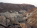 The Judean Hills viewed from the Dead Sea
 View from hilltop overlooking Wadi es-Ṣur, an extension of the Elah Valley in Israel
 View from Beit Meir in the Judaean Mountains
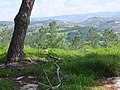 Idyllic scene in the Judean mountains, overlooking the village of Khirbet ed-Deir which sits along the Green Line
 The ruined structure of an ancient house, near Neve Michael


See also
- Judaean Desert, the arid area in the eastern Judaean Mountains and western Jordan Rift Valley
- Mount of Temptation (Jebel Quruntul)
References
- Peter N. Peregrine, Melvin Ember, ed. (2003-03-31). Encyclopedia of Prehistory: South and Southwest Asia. Vol. 8. ISBN 9780306462627. Retrieved 2012-02-13.
- Judaean_Mountains - Mapcarta
- Brenner, Michael (2010). A short history of the Jews. Princeton, N.J.: Princeton University Press. ISBN 978-0-691-14351-4. OCLC 463855870.
- Legacy: a Genetic History of the Jewish People. Harry Ostrer. Oxford University Press USA. 2012. ISBN 978-1-280-87519-9. OCLC 798209542.
{{cite book}}: CS1 maint: others (link) - Adams, Hannah (1840). The history of the Jews : from the destruction of Jerusalem to the present time. Sold at the London Society House and by Duncan and Malcom, and Wertheim. OCLC 894671497.
- Palestine: Land, Encyclopaedia Britannica
- Stone, Lawson G. (2016). Philip W. Comfort (ed.). Judges (Judges 13:1-25). Cornerstone Biblical Commentary: Joshua, Judges, Ruth. Vol. 3. Tyndale House. pp. 381–382. ISBN 9781414398792. Retrieved 11 December 2019.
- Jerusalem Hills - Mapcarta
- Arieh Singer (2007). The Soils of Israel. Springer. pp. 129, 143.
- Abd El-Motaal, Essam; Kusky, Timothy M. (2003). Tectonic Evolution of the Intraplate S-Shaped Syrian Arc Fold-Thrust Belt of the Middle East Region in the Context of Plate Tectonics (PDF). The third international conference on the geology of Africa, Vol.2, December 2003, Assiut, Egypt, pp. 139–157. Archived from the original (PDF) on 2016-03-03. Retrieved 2012-02-23.
- Flexer A. (1989). "Late Cretaceous evolution of the Judean Mountains as indicated by ostracodes". Terra Nova. 1 (4): 349–358. Bibcode:1989TeNov...1..349F. doi:10.1111/j.1365-3121.1989.tb00385.x.
- Bar, Oded; Zilberman, Ezra; Feinstein, Shimon; Calvo, Ran; Gvirtzman, Zohan (2016). "The uplift history of the Arabian Plateau as inferred from geomorphologic analysis of its northwestern edge". Tectonophysics. 671: 9–23. Bibcode:2016Tectp.671....9B. doi:10.1016/j.tecto.2016.01.004.
- "History of Jerusalem from Its Beginning to David". Biu.ac.il. 1997-03-06. Retrieved 2012-02-13.
- "Cambridge History of Judaism". Cambridge.org. p. 210. Retrieved 16 August 2011. "In both the Idumaean and the Ituraean alliances, and in the annexation of Samaria, the Judaeans had taken the leading role. They retained it. The whole political–military–religious league that now united the hill country of Palestine from Dan to Beersheba, whatever it called itself, was directed by, and soon came to be called by others, 'the Ioudaioi'"
- A History of the Jewish People, edited by Haim Hillel Ben-Sasson, page 226, "The name Judea no longer referred only to...."
External links
 Media related to Judaean Mountains at Wikimedia Commons
- Pictures
- Judaean Mountains & Jerusalem
- Symbolism and Landscape: The Etzion Bloc in the Judaean Mountains, Yossi Katz and John C. Lehr
Authority control | |
|---|---|
| General |
|
| National libraries | |
На других языках
- [en] Judaean Mountains
[fr] Monts de Judée
Les monts de Judée, en hébreu הרי יהודה, en arabe يهودا جبال (jibâl yahudâ), sont une chaîne de collines et de plateaux d'Israël et de Palestine situés entre la vallée du Jourdain à l'est et les plaines littorales de la mer Méditerranée à l'ouest. Ils se prolongent par la Galilée au nord et le Néguev au sud.[it] Monti della Giudea
I Monti della Giudea (ebraico: הרי יהודה Harei Yehuda, arabo: جبال يهودا Jibal Yahuda) sono una catena montuosa in Israele e in Cisgiordania, dove si trovano Gerusalemme e molte altre città bibliche.[ru] Иудейские горы
Иудейские горы (ивр. הרי יהודה, Harei Yehuda; араб. جبال الخليل, Jibal al-Khalil) — горы 800—900 м над уровнем моря, расположенные на востоке Израиля — вокруг Иерусалима до Иудейской пустыни, которая спускается к Мертвому морю.Другой контент может иметь иную лицензию. Перед использованием материалов сайта WikiSort.org внимательно изучите правила лицензирования конкретных элементов наполнения сайта.
WikiSort.org - проект по пересортировке и дополнению контента Википедии