geo.wikisort.org - Mountains
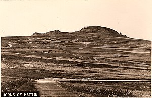
The Horns of Hattin ( Hebrew: קרני חיטין, romanized: Karnei Hittin Arabic: قرون حطين, romanized: Qurûn Hattîn) is an extinct volcano with twin peaks overlooking the plains of Hattin in the Lower Galilee, Israel.
| Horns of Hattin | |
|---|---|
 View of the Horns of Hattin from the west. Sea of Galilee is in the background. | |
| Highest point | |
| Elevation | 326 m (1,070 ft) |
| Coordinates | 32°48′00″N 35°27′34″E |
| Naming | |
| Etymology | from Hebrew חִטִּ֨ים (ḥiṭṭîm) 'wheat' |
| Native name |
|
| Geography | |
| Location | Lower Galilee, Israel |

Kurûn Hattîn is believed to be the site of the Battle of Hattin, Saladin's victory over the Crusaders in 1187. The Battle of Hattin was fought in summer when the grass was tinder-dry. Saladin's troops set fire to the grass, after cutting off the Crusaders' access to water in the Sea of Galilee.[1] Saladin built a "victory dome," Qubbat al-Nasr, on the hill.[citation needed] Thietmar, a German pilgrim who visited the site in 1217, wrote that the "temple Saladin had erected to his gods after the victory is now desolate." In the early 17th century, ruins were found on the summit that appeared to be those of a church. Prior to 1948, an Arab village, Hittin, lay at the foot of the hill.[2] Excavations were carried out on the hill in 1976 and 1981.[3]
Some scholars have identified the hill with the Mount of Beatitudes, where Jesus delivered his Sermon on the Mount.[4][5] Writing in 1864, Fergus Ferguson describes it as the "supposed" site, because although "its position corresponds with the particulars of the narrative", no one can declare with any certainty that He gave a sermon at that exact spot."[2]
References
- Region lived through centuries of warfare[permanent dead link]
- Ferguson, 1864, p. 297
- The Battle of Hattin Revisited, Benjamin Kedar Archived 2010-03-27 at the Wayback Machine
- Livingston, p. 340.
- Tischendorf and Shuckard, 1847, p. 240.
Bibliography
- Ferguson, Fergus (1864), Sacred Scenes, Or, Notes of Travel in Egypt and the Holy Land: Or, Notes of Travel in Egypt and the Holy Land, Thomas Adamson; Jackson, Walford, and Hodder; W.P. Nimmo
- Wilson, Edward Livingston, In Scripture Lands: New Views of Sacred Places, Adamant Media Corporation, ISBN 978-1-4021-5515-4, ISBN 1-4021-5515-8
- Tischendorf, Lobegott Friedrich Constantin; Shuckard, W.E. (1847), Travels in the East, tr. from [Reise in den Orient], Oxford University
На других языках
[de] Hörner von Hittim
Als Hörner von Hittim oder Hörner von Hattin (arabisch Ḥaṭṭīn) bezeichnet man einen niedrigen Berg wenige Kilometer westlich des Sees Genezareth in Nordisrael. Den Namen erhielt er wegen seines Doppelgipfels, eines Überbleibsels der wenigen erkennbaren Vulkane westlich des Jordan.- [en] Horns of Hattin
[es] Cuernos de Hattin
Los Cuernos de Hattin (en árabe: Kûrun Hattîn, en hebreo קרני חיטין, Karnei Jitín) es el nombre de un monte de unos 326 metros de altura situado en la Baja Galilea (Israel), cerca de la planicie de Hattin y del Monte Arbel. Se trata de un volcán apagado, y lleva dicho nombre por sus dos picos que se asemejan a un par de cuernos. Desde los Cuernos de Hattin es posible ver el Lago Kineret, el Gilad, el Golán y la Galilea.[ru] Рога Хаттина
Рога́ Хатти́на (Рога́ Хитти́на, Карней Хиттим, ивр. קרני חיטין, Карней Хиттин; араб. قرون حطينKûrun Hattîn) — гора вулканического происхождения в Нижней Галилее, в Израиле, примерно в 6 км западнее Тверии. От кратера потухшего вулкана остались два холма, две вершины, северная и южная.Другой контент может иметь иную лицензию. Перед использованием материалов сайта WikiSort.org внимательно изучите правила лицензирования конкретных элементов наполнения сайта.
WikiSort.org - проект по пересортировке и дополнению контента Википедии