geo.wikisort.org - Mountains
Ben More (Scottish Gaelic: Beinn Mhòr, "the great mountain")[2] is a mountain in the Breadalbane region of the southern Scottish Highlands, near Crianlarich. Rising to 1,174 metres (3,852 ft), it is a Munro and is the highest of the so-called Crianlarich Hills to the south-east of the village. There is no higher land in the British Isles south of Ben More. It is separated from Stob Binnein (1,165 m or 3,822 ft) by the Bealach-eadar-dha Beinn, "col between two mountains". It is the highest peak in the Loch Lomond and The Trossachs National Park.
This article needs additional citations for verification. (June 2019) |
| Ben More | |
|---|---|
| Beinn Mhòr | |
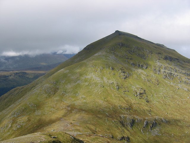 Ben More from Stob Binnein, showing the conical shape of the hill and the tilted rockbands of the mica schist | |
| Highest point | |
| Elevation | 1,174 m (3,852 ft)[1] |
| Prominence | c. 986 metres (3,235 ft) Ranked 6th in British Isles |
| Parent peak | Ben Nevis |
| Listing | Munro, Marilyn, Council top (Stirling) |
| Naming | |
| English translation | big mountain |
| Language of name | Gaelic |
| Pronunciation | Gaelic [ə ˈveiɲ ˈvoːɾ] ( |
| Geography | |
| Location | Stirlingshire, |
| Parent range | Grampian Mountains |
| OS grid | NN432244 |
| Topo map | OS Landranger 51, Explorer 365 |
Ben More's north side contains a long-lasting snow patch, which – uniquely in the Southern Highlands – is named on a 1:25000 Ordnance Survey map, and is called the Cuidhe Chrom (crooked wreath), on account of the shape it forms in late spring/early summer. This patch frequently lasts until well into June and sometimes July. The similar name Cuidhe Cròm appears as a summit near Lochnagar.
Climbing
The simplest ascent starts from Benmore Farm on the A85. Initially, one should follow the path leading up Benmore Burn, before leaving this path and heading up the northwest ridge of Ben More. The ridge is unrelentingly steep, rising 1,000 m (3,300 ft) in about four kilometres (2+1⁄2 mi). The northeast ridge may prove a preferable alternative, being craggier and less steep. To reach this the walker should follow the burn of Allt Coire Chaorach, before striking for the ridge of Sròn nam Fòirsairean once clear of the forestry that cloaks the lower slopes of this side of Ben More. This route is around five kilometres (3 mi) long.
Ben More is often climbed in conjunction with Stob Binnein by descending to the Bealach-eadar-dha Beinn and then on to the second peak. Descent may be made from the col direct to Benmore Burn.
In the event of an incident, Killin Mountain Rescue Team are on duty.[3]
A webcam located at the eastern edge of Crianlarich captures Ben More. It provides updates every 10 minutes. See http://www.benmorewebcam.co.uk
Air crashes
On 19 January 1973, a Vickers Viscount of British European Airways took off from Glasgow International Airport at about 14:20 on a test flight to be conducted at Flight Level (FL) 40; in the conditions prevailing at the time FL40 was equivalent to about 3,850 feet (1,173 m).[4] At about 14:32 the aircraft flew into Ben More about 600 ft (180 m) northeast and 100 ft (30 m) below the summit while flying in a westerly direction.[4] The two pilots and two passengers on board were killed in the accident. The Air Accidents Investigation Branch (AAIB) found that the aircraft struck Ben More whilst flying over snow-covered high terrain in marginal visual meteorological conditions and said that "Failure to maintain a safe altitude and insufficient attention to navigational procedures were contributory factors".[4][5]

On 12 May 2012, two men were killed when their microlight aircraft crashed into the mountain at about 12:00 midday.[6]
See also
References
- "Stob Binnein". Hill Bagging - the online version of the Database of British and Irish Hills (DoBIH). 2019. Retrieved 20 June 2019.
- "Ben More (Stirlingshire)". Ainmean-Àite na h-Alba: Gaelic Place-Names of Scotland.
- Killin Mountain Rescue Team. "Killin Mountain Rescue Team". Archived from the original on 17 January 2014. Retrieved 28 February 2013.
- AAIB website access page for AAIB Report No 4/1974, Viscount 802, G-AOHI. Report on the accident at Ben More, Perthshire, Scotland, on 19 January 1973
- Aviation Safety Network accident description
- "Stirlingshire mountain microlight crash kills two men", BBC News, 13 May 2012
External links
- Ben More (Crianlarich) is at coordinates 56.386381°N 4.539267°W
- Computer generated summit panorama (Index)
- Ben More - Crianlarich, map and large images
 |
|  | |
List of Munros | |||
Most prominent mountains of Britain and Ireland (the P600s) | ||
|---|---|---|
| Northern Highlands (20) |    | |
| Western Highlands (20) | ||
| Central and Eastern Highlands (13) | ||
| Southern Highlands (15) |
| |
| Islands (13) | ||
| Scottish Lowlands, England and Wales (13) | ||
| Republic of Ireland, Northern Ireland (25) | ||
На других языках
[de] Ben More (Crianlarich)
Der Ben More (A' Bheinn Mhòr auf Gälisch) ist ein 1.174 m (3.852 ft) hoher Berg in Schottland. Sein Name bedeutet Großer Berg.[1] Er liegt in den südlichen Highlands südöstlich der Ortschaft Crianlarich oberhalb von Glen Dochart in der Council Area Stirling im Loch Lomond and the Trossachs National Park und zählt zu den Munros. Auf der Liste der höchsten schottischen Berge nimmt er Platz 16 ein und ist der höchste britische Berg südlich des Tay.- [en] Ben More (Crianlarich)
[es] Ben More (Crianlarich)
Ben More (en gaélico escocés Beinn Mhòr pronunciado [peiɲ voːɾ], que significa "gran montaña") es una montaña y munro en el sur de las Tierras Altas de Escocia (Reino Unido), cerca de Crianlarich. Es la más alta de las llamadas colinas Crianlarich al sureste del pueblo, y no hay tierra más alta en las islas Británicas al sur de Ben More. Está separado de Stob Binnein por el Bealach-eadar-dha Beinn, que significa "collado entre dos colinas".Другой контент может иметь иную лицензию. Перед использованием материалов сайта WikiSort.org внимательно изучите правила лицензирования конкретных элементов наполнения сайта.
WikiSort.org - проект по пересортировке и дополнению контента Википедии