geo.wikisort.org - Island
Onekotan (Russian: Онекотан; Japanese 温禰古丹島; Onekotan-tō, occasionally Onnekotan-tō, Ainu: オネコタン or オネコタㇴ) is an uninhabited volcanic island located near the northern end of the Kuril Islands chain in the Sea of Okhotsk in the northwest Pacific Ocean. Its name is derived from the Ainu language for "large village”. It is the second largest island, after Paramushir, in the northern subgroup of the Kurils. It is administratively included in the Severo-Kurilsky District of Sakhalin oblast, Russia.
This article needs additional citations for verification. (March 2012) |
Native name: Онекотан 温禰古丹島 | |
|---|---|
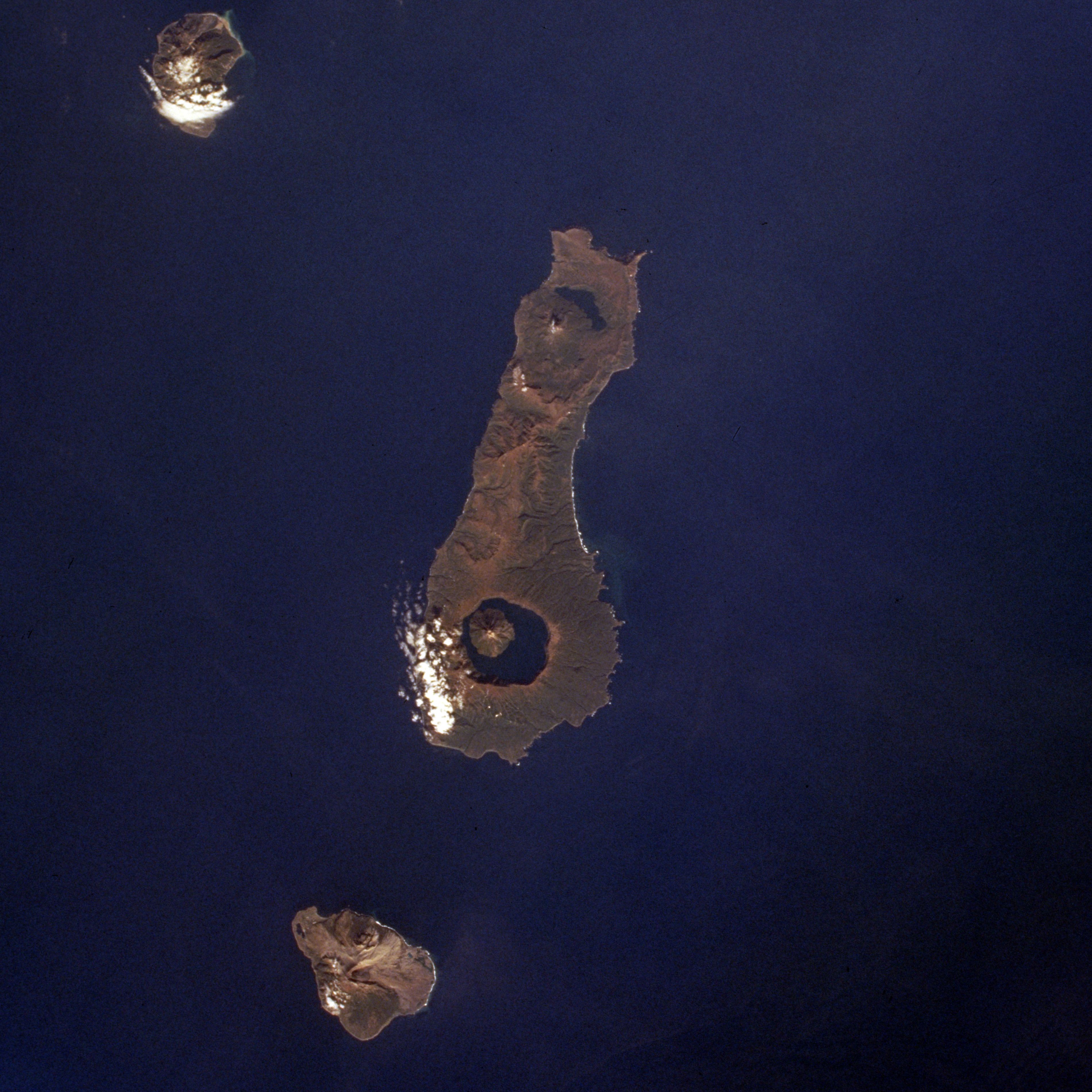 Onekotan Island (centre) from space, October 1994. North at top | |
 | |
| Geography | |
| Location | Sea of Okhotsk |
| Coordinates | 49°27′N 154°46′E |
| Archipelago | Kuril Islands |
| Area | 425 km2 (164 sq mi) |
| Highest elevation | 1,324 m (4344 ft) |
| Highest point | Krenitsyn |
| Administration | |
Russia | |
| Demographics | |
| Population | 0 |
| Ethnic groups | Ainu (formerly) |
Geography and geology
Onekotan is roughly rectangular, with a length of 42.5 kilometers (26.4 mi), and a width ranging from 11 to 17 kilometers (6.8 to 10.6 mi). It has an area of 425 square kilometers (164 sq mi) [1]
The island consists of two stratovolcanos connected by a relatively flat isthmus.
- Krenitsyn -(Russian: Креницын; Japanese 黒石山; Kuroishiyama) with a height of 1,324 meters (4,344 ft) is the prominent caldera at the southern end of the island. This volcano was named after Captain Pyotr Krenitsyn of the Imperial Russian Navy.[2] The mountain rises from a depth of from 600 to 900 meters (2,000 to 3,000 ft), and contains a deep (369 m, 1,211 ft) central caldera lake with a diameter of 7 kilometers (4.3 mi), called Tao-Rusyr Caldera. The central peak of this "island within the island" is actually the highest point on Onekotan Island
- Nemo -(Russian: влк Немо; Japanese 根茂山; Nemoyama) with a height of 1,019 meters (3,343 ft) is the peak to the north. It has two nested subsidiary calderas, with the cone of Nemo Peak rising in the southwest end of the youngest caldera and a crescent-shaped crater lake, named Lake Chernoye, partially filling the northeast part.
There are seven rivers on the island more than five kilometers long. The largest is Ozernaya River (8 kilometers (5.0 mi) long, which flows from the southern part of the caldera of the Nemo volcano to the Sea of Okhotsk. Almost the same length is the Kedrovka River, which flows from the central part of the island into the Pacific Ocean.
The climate of Onekotan is characterized by short, cool summers, high humidity, frequent fogs, and especially strong winds. However, the island's climate is generally considered to be mild oceanic with an average annual temperature of about 4.0 °C (39.2 °F). Even in record cold winters, temperatures below −15 °C (5 °F) were not observed.
Onekotan is separated from the neighboring islands by the Fourth Kuril Strait, Yevreinov Strait, and Krenitsyn Strait. The neighboring islands are Makanrushi, with a 1,170-meter (3,840 ft) volcanic peak, is 28 kilometers (17 mi) to the northwest of Onekotan; and Kharimkotan, with a 1,210-meter (3,970 ft) high volcano, is 15 kilometers (9.3 mi) to the southwest. Paramushir is located 53 kilometers (33 mi) to the northeast.
Onekotan still has an active volcano with the most recent eruption, in 1952, forming a small lava dome on the island's coast. A bay on the eastern shore contains the remains of an abandoned settlement.
- Onekotan
 Mount Krenitsyn on Onekotan Island
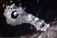 Snow cover highlights the calderas and volcanic cones that form the northern and southern ends of Onekotan.

Climate
History
Onekotan, with a number of shallow bays and sandy beaching providing landing points, was inhabited by the Ainu prior to European contact. It appears on an official map showing the territories of Matsumae Domain, a feudal domain of Edo period Japan dated 1644, and these holdings were officially confirmed by the Tokugawa shogunate in 1715.
The island was surveyed by Russian geodesists and explorers Ivan Yevreinov and Fyodor Luzhin in 1720, and was subsequently, claimed by the Empire of Russia in 1736 after the Ainu inhabitants were converted to the Russian Orthodox Church; however Russian tax collectors encountered Japanese officials on the islands in 1744–45.
Sovereignty initially passed to Russia under the terms of the 1855 Treaty of Shimoda, but was returned to the Empire of Japan per the Treaty of Saint Petersburg in 1875 along with the rest of the Kuril islands. The island was formerly administered as part of Shimushu District of Nemuro Subprefecture of Hokkaidō. In 1884, the Ainu inhabitants were relocated by Japanese authorities to Shikotan.
During World War II, the island had a small Japanese garrison, which surrendered on August 25, 1945 without a fight.
After 1945, the island came under the control of the Soviet Union, and is now administered as part of the Sakhalin Oblast of the Russian Federation. A small garrison on the island was withdrawn in 2005.
Flora and fauna
There are chars in Lake Chyornoye, one of the two lakes on Onekotan, located at the northern end of the island.
In the spring and summer pigeon guillemot and Leach's storm petrel nest on the island.[3]
Mammals found on the island include foxes and small rodents, with seals and sea lions on the coast.
The strong winds and harsh climate limit the growth of trees to small thickets of Krummholz formations of Siberian dwarf pine with a maximum height of 2–4 meters, mostly in gullies.
See also
- List of volcanoes in Russia
- List of islands of Russia
- List of islands
- Desert island
Notes
- "International Kuril Island Project(IKIP)". University of Washington Fish Collection or the respective authors. Archived from the original on 2013-07-23. Retrieved 2010-05-23.
- "Tao-Rusyr Caldera". Global Volcanism Program. Smithsonian Institution. Retrieved 2021-06-25.
- Kondratyev, A. Y., Litvinenko, N. M., Shibaev, Y. V., Vyatkin, P. S., & Kondratyeva, L. F. (2000). "The breeding seabirds of the Russian Far East". Seabirds of the Russian Far East, 37-81.
Further reading
- Gorshkov, G. S. Volcanism and the Upper Mantle Investigations in the Kurile Island Arc. Monographs in geoscience. New York: Plenum Press, 1970. ISBN 0-306-30407-4
- Krasheninnikov, Stepan Petrovich, and James Greive. The History of Kamtschatka and the Kurilski Islands, with the Countries Adjacent. Chicago: Quadrangle Books, 1963.
- Rees, David (1985). The Soviet Seizure of the Kuriles. Praeger Publishers. ISBN 978-0-03-002552-5.
- Takahashi, Hideki, and Masahiro Ōhara. Biodiversity and Biogeography of the Kuril Islands and Sakhalin. Bulletin of the Hokkaido University Museum, no. 2-. Sapporo, Japan: Hokkaido University Museum, 2004.
External links
| Wikimedia Commons has media related to Onekotan. |
- NASA Earth from Space: Onekotan Island
- Photographs of Onekotan Island
- Shubina, E. A; Ponomareva, E. V; Gritsenko, O. F (2006). "Population genetic structure of the char species of the Northern Kuril Islands and the rank of the Dolly Varden Char in the system of the genus Salvelinus (Salmonidae: Teleostei)". Zhurnal Obshchei Biologii. 67 (4): 280–97. PMID 17022488.
- Onekotan - The Lost Island - A movie about 3 Athletes on the lost island Onekotan.
|
Authority control | |
|---|---|
| General |
|
| National libraries | |
На других языках
[de] Onekotan
Onekotan (russisch Онекотан; japanisch .mw-parser-output .Hani{font-size:110%}温禰古丹島 .mw-parser-output .Latn{font-family:"Akzidenz Grotesk","Arial","Avant Garde Gothic","Calibri","Futura","Geneva","Gill Sans","Helvetica","Lucida Grande","Lucida Sans Unicode","Lucida Grande","Stone Sans","Tahoma","Trebuchet","Univers","Verdana"}Onekotan-tō) ist eine zu Russland gehörende Insel der nördlichen Kurilengruppe. Die nächstgelegenen Inseln sind Makanruschi im Nordwesten und Charimkotan im Süden.- [en] Onekotan
[es] Onekotan
Onekotan (en ruso, Онекотан) es una isla rusa en el archipiélago de las Kuriles. Tiene una superficie de 425 km². Pertenece al grupo de las Kuriles septentrionales.[fr] Onekotan
L'île Onekotan (russe : Онекотан ; japonais : 温禰古丹島 ; Onekotan-tō, parfois Onnekotan-tō, aïnou : オネコタン ou オネコタㇴ) est une île volcanique inhabitée située près de la frontière nord de la chaîne des îles Kouriles de la mer d'Okhotsk, dans le nord-ouest de l'océan Pacifique. Son nom signifie « grand village » en aïnou.[it] Onekotan
L'isola di Onekotan (in russo Онекотан; in giapponese 温禰古丹島, Onekotan-tō) è un'isola dell'arcipelago delle Isole Curili settentrionali ed è situata tra il Mare di Ochotsk e l'Oceano Pacifico settentrionale. Amministrativamente fa parte del Severo-Kuril'skij rajon dell'oblast' di Sachalin, nel Circondario federale dell'Estremo Oriente. Il suo nome viene dalla lingua ainu e significa "grande villaggio" (si riferiva inizialmente solo al villaggio sull'isola). L'isola è disabitata.[ru] Онекотан
Онекота́н (Анакутан; от айн. Онне кота́н: онне — «старый, почётный, ценный, большой», котан — «деревня, усадьба, жилище; город, городок, местечко», то есть первоначально название относилось только к селению на острове[1]; на российской карте 1745-го года — Галантъ[2]) — крупный остров вулканического происхождения в составе северной группы Большой гряды Курильских островов. Второй по величине, после Парамушира, в северной подгруппе Курил. Административно входит в Северо-Курильский городской округ Сахалинской области. С 2005 года необитаем, хотя в разные периоды попытки его хозяйственного освоения предпринимали айны, японцы, русские и другие представители народов России.Другой контент может иметь иную лицензию. Перед использованием материалов сайта WikiSort.org внимательно изучите правила лицензирования конкретных элементов наполнения сайта.
WikiSort.org - проект по пересортировке и дополнению контента Википедии