geo.wikisort.org - Island
Iturup (Russian: Остров Итуру́п, romanized: Ostrov Iturúp[1]; Ainu: エツ゚ヲロㇷ゚シㇼ, romanized: Etuworop=sir; Japanese: 択捉島, romanized: Etorofu-tō,[2] historically also called Etrof[3] and Yetorup) is one of the Kuril Islands. It was formerly known as Staten Island.[4] It is the largest and northernmost island in the southern Kurils, ownership of which is disputed by Japan and Russia.
| Disputed island Native name: Ainu: エツ゚ヲロㇷ゚シㇼ Other names: Russian: Итуру́п; Japanese: 択捉島 | |
|---|---|
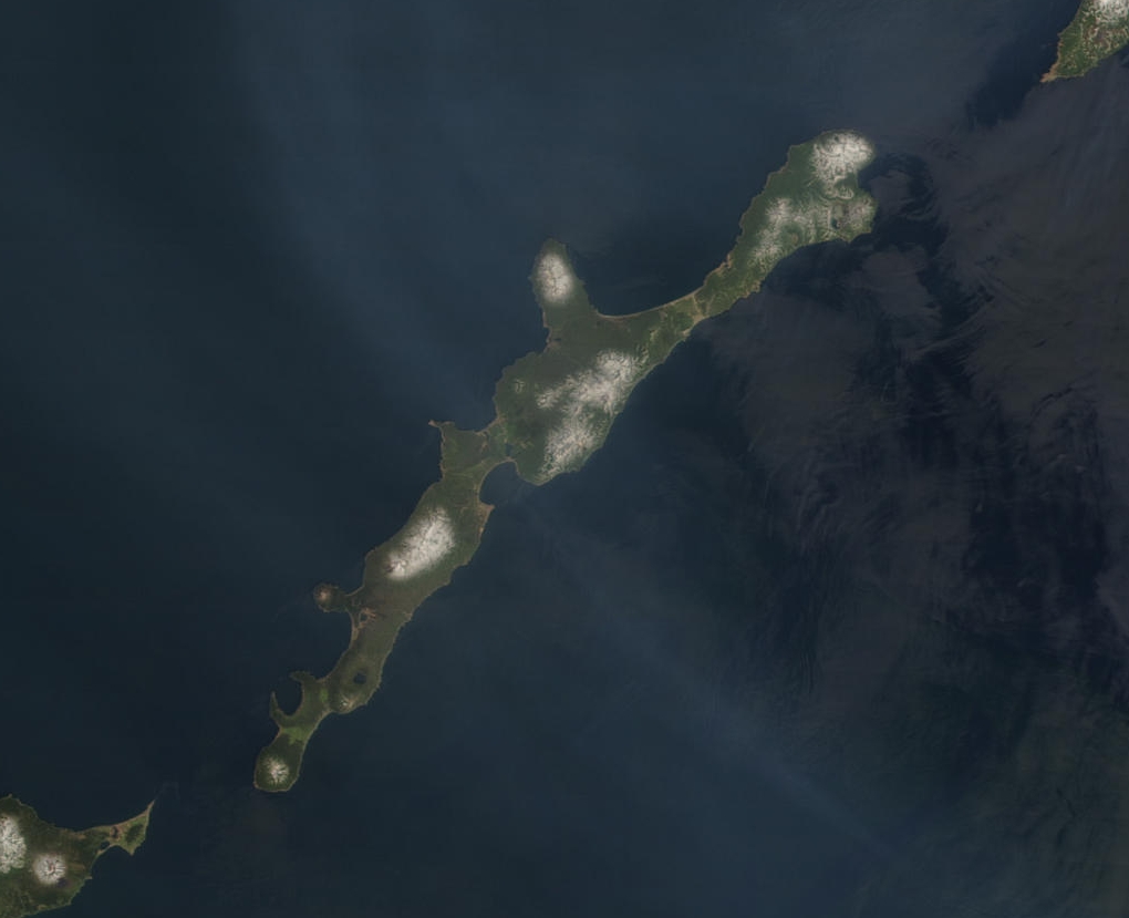 NASA image of Iturup with Berutarube volcano at the southern end of the island | |
| Geography | |
| Location | Sea of Okhotsk |
| Coordinates | 45°02′N 147°37′E |
| Archipelago | Kuril Islands |
| Area | 3,139 km2 (1,212 sq mi) |
| Length | 200 km (120 mi) |
| Width | 27 km (17 mi) |
| Highest point |
|
| Administered by | |
| Federal subject | Sakhalin Oblast |
| District | Kurilsky |
| Claimed by | |
| Prefecture | Hokkaido |
| Subprefecture | Nemuro |
| Demographics | |
| Population | 7,500 (as of 2003) |
The island was Japanese territory from 1855 until the end of the Second World War in 1945, when Soviet forces took possession of all the Kurils and forced out Japanese residents. The island is still claimed by Japan, which considers a site on Iturup to be its northernmost point.
Iturup is located near the southern end of the Kuril chain, between Kunashiri (19 km to the SW) and Urup (37 km to the NE). The town of Kurilsk, administrative center of Kurilsky District, is located roughly midway along its western shore.
Iturup and Urup are separated by the Vries Strait, named after Dutch explorer Maarten Gerritsz Vries, the first recorded European to explore the area.[5]
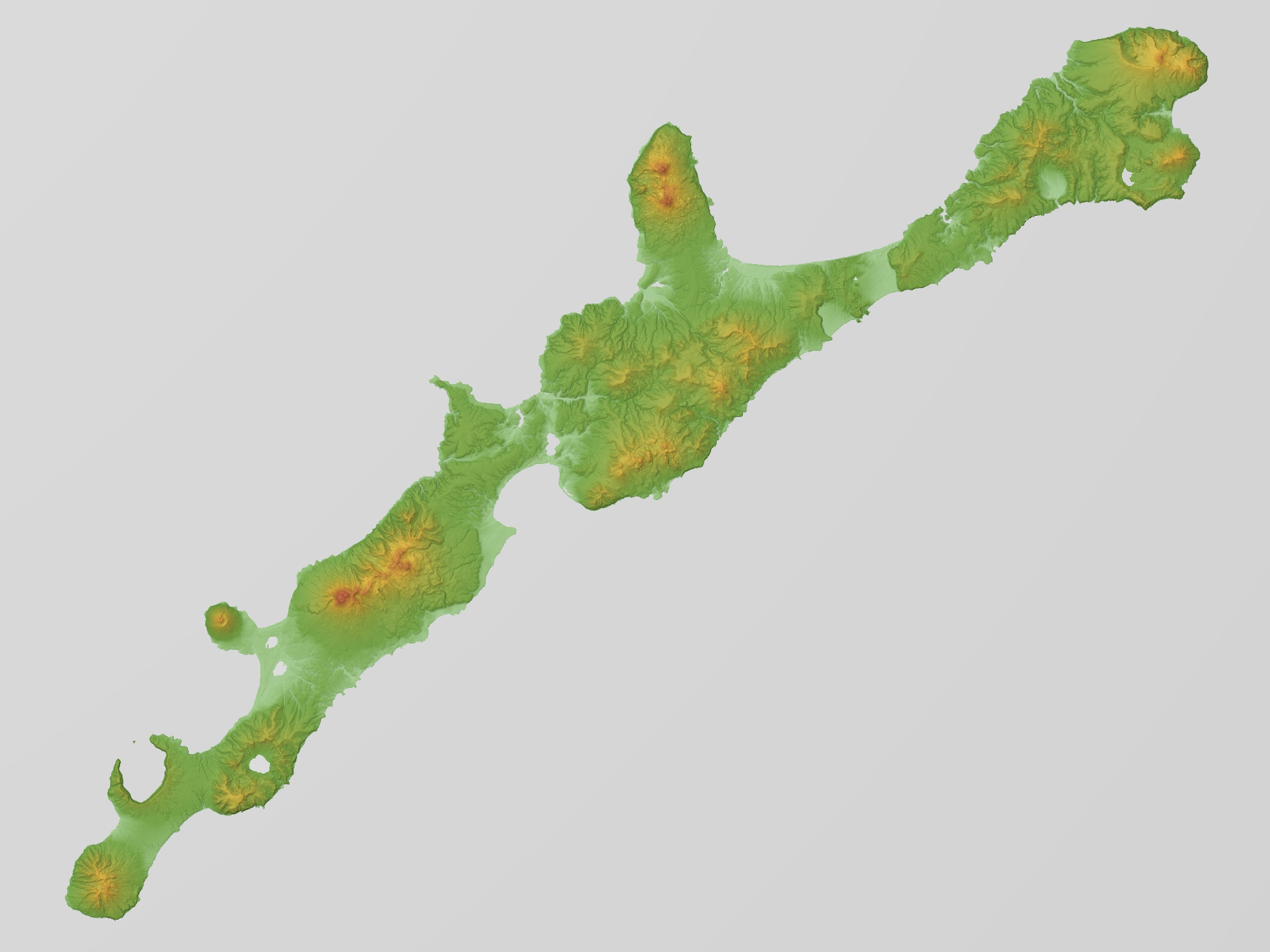
Geography
Iturup consists of volcanic massifs and mountain ridges. A series of a dozen calc-alkaline volcanoes running NE to SW form the backbone of the island, the highest being Stokap (1,634 m) in the central part of Iturup. The shores of the island are high and abrupt. The vegetation mostly consists of spruce, larch, pine, fir, and mixed deciduous forests with alder, lianas and Kuril bamboo underbrush. The mountains are covered with birch and Siberian Dwarf Pine scrub, herbaceous flowers (including Fragaria iturupensis, the Iturup strawberry) or bare rocks.
The island also contains some high waterfalls, such as the Ilya Muromets.
Rheniite, a rhenium sulfide mineral (ReS2), was discovered in active hot fumaroles on Kudriavy volcano and first described in 2004. In the field it was originally mistaken for molybdenite.[6]
History
Post-classical (500 to 1450)
The native inhabitants of Iturup and the Kuril islands are the Ainu. They lived there since before the 14th century.
Edo period
Iturup was reached in 1661 by the Japanese Shichirobei and his fellows after they had drifted there. The island saw both a Russian settlement (late 18th century) and a Japanese garrison (1800) at the site of the present-day Kurilsk. In 1855 Iturup was ceded to Japan by the Treaty of Shimoda. Its name comes from the Ainu エツ゚ヲロㇷ゚ (Etuworop), meaning "Place possessing [many] capes."
Showa period
On 26 November 1941, a Japanese carrier fleet left Hitokappu Bay (now called Kasatka Bay[7]), on the eastern shore of Iturup, and sailed for an attack on the American base of Pearl Harbor.
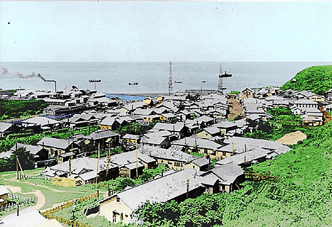
Shana Village was located on Iturup (Etorofu) in the Showa era, before 1945. It was the administrative capital of the Kuril islands. There was a village hospital, an Etorofu Fisheries factory, a radio tower of the post office with a radio receiving antenna. The receiver was battery-powered.[8]
Post-World War II
In 1945, according to decisions of the Yalta Conference, it was occupied by the Soviet Union after Japan's defeat in World War II. The Japanese inhabitants were expelled to mainland Japan.[9] In 1956 the two countries agreed to restore diplomatic relations, but a peace treaty, as of 2022[update], has not been concluded due to the disputed status of Iturup and some other nearby islands.
A Soviet Anti-Air Defense (PVO) airfield, Burevestnik (English: storm-petrel), is located on the island and was until 1993 home for a number of Mikoyan-Gurevich MiG-23 fighter jets.[10] In 1968, Seaboard World Airlines Flight 253A was intercepted over the Kurils and forced to land at Burevestnik with 214 American troops bound for Vietnam. An older airfield, Vetrovoe, exists on the eastern part of the island and may have been used primarily by Japanese forces during World War II.
Contemporary period
A new international airport, Iturup Airport, was opened in 2014, 7 kilometres (4+1⁄2 miles) east of Kurilsk. It was the first airport built from scratch in Russia's post-Soviet history. It has a 2.3-kilometre-long (7,500 ft), 42-metre-wide (138 ft) runway and can receive Antonov An-74-200 aircraft. It also has a military use. The Burevestnik military airfield 60 km (37 mi) to the south, in the past received civilian aircraft as well, but was often closed because of fog. Burevestnik is now a reserve airfield for the new airport.[11] On February 2, 2018, PBS NewsHour reported that Russia announced it is sending fighter planes to Iturup.[12] Su-35 aircraft landed on a reserve airfield on the island in March 2018[13][14] and Su-35s were then deployed to Iturup airport on a trial basis in August 2018.[15]
Administratively the island belongs to the Sakhalin Oblast of the Russian Federation. Japan claims Iturup as part of Nemuro Subprefecture.
Gallery
- Iturup
 Volcanoes of Iturup
 Rheniite crystals on a base of hardened lava, from Kudriavy Volcano
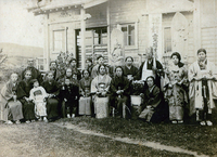 Japanese Iturup residents (then called Etorofu) and a Buddhist temple (before 1939)
 Shana Village in Etorofu (Shōwa period). There is a village hospital in the front, a factory in the left back with a fishery and a central radio tower (before 1945).
 Iturup, 1981
 Trees showing effect of prevailing wind, 1981
 Kurilsk, 1981


See also
- Kuril Islands dispute
References
- "Ostrov Iturup: Russia". Geographical Names. Retrieved 2014-02-24.
- "Etorofu-tō: Russia". Geographical Names. Retrieved 2014-02-24.
- Contemporary Japan, Volume 24. Foreign Affairs Association of Japan. 1956. p. 520.
- Heawood, Edward (1912). A history of geographical discovery in the seventeenth and eighteenth centuries. Cambridge: Cambridge University Press. pp. 87.
- Dutch exploration Archived 2008-03-25 at the Wayback Machine
- Korzhinsky, M.A.; Tkachenko, S. I.; Shmulovich, K. I.; Taran, Y. A.; Steinberg, G. S. (5 May 2004). "Discovery of a pure rhenium mineral at Kudriavy volcano". Nature. 369 (6475): 51–52. Bibcode:1994Natur.369...51K. doi:10.1038/369051a0. S2CID 4344624.
- Внешняя политика Японии: сентябрь 1939 г.-декабрь 1941 г – 1959, page 246 (in Russian)
- "Sana, the administrative capital - 行政の首都 紗那(しゃな)". Chishima People's Magazine Study Group (千島庶民誌研究会). 6 October 2016. Archived from the original on 10 November 2017. Retrieved 20 January 2020.
- Takahara, "Nemuro raid survivor"
- Austin, Greg; Muraviev, Alexey D. (2000). The Armed Forces of Russia in Asia. London: I.B.Tauris. p. 244. ISBN 9781860644856. Retrieved 16 June 2018.
- "New airport on Kuril Iturup Island receives first flight". Russia Beyond. Interfax. 22 September 2014. Retrieved 16 June 2018.
- "PBS NewsHour full episode February 2, 2018 (Time Index 8:37)". Retrieved 26 October 2014.
- "Russian fighter jets land on disputed island". Xinhua News Agency. March 26, 2018. Archived from the original on August 5, 2018. Retrieved August 5, 2018.
- Gady, Franz-Stefan (August 1, 2018). "Japan Asks Russia to Reduce Militarization of Disputed Kuril Islands". The Diplomat. Retrieved August 5, 2018.
- "Report: Fighter jets deployed on Etorofu for trial". NHK. August 4, 2018. Retrieved August 5, 2018.
External links
- Takahara, Kanako (September 22, 2007). "Nemuro raid survivor longs for homeland" (Newspaper article). Japan Times. Retrieved 2008-02-01.
- Google Maps
- Ocean Dots.com at the Wayback Machine (archived December 23, 2010)
- Sakhalin Oblast
На других языках
[de] Iturup
Iturup (russisch Итуруп; japanisch 択捉島 .mw-parser-output .Latn{font-family:"Akzidenz Grotesk","Arial","Avant Garde Gothic","Calibri","Futura","Geneva","Gill Sans","Helvetica","Lucida Grande","Lucida Sans Unicode","Lucida Grande","Stone Sans","Tahoma","Trebuchet","Univers","Verdana"}Etorofu-tō) ist eine Insel des Kurilen-Archipels. Die Insel gehört de facto zu Russland, wird aber von Japan als Teil der Unterpräfektur Nemuro, Hokkaidō beansprucht.- [en] Iturup
[es] Iturup
Iturup (en ruso: Итуруп, Ostrov Iturup;[1] en japonés: 択捉島, Etorofu-tō[2]) es la isla más grande del archipiélago de las Kuriles, con una superficie de 3.139 km². Al noreste se encuentra la isla Urup, separada por el estrecho de Vries, y al suroeste la isla Kunashir, separada por el estrecho de Ekaterina.[fr] Itouroup
Itouroup (en russe : Итуруп, Остров Итуру́п, Ostrov Itouroup[1] ; en aïnou エトゥオロプシリ, Etuworop-sir ; en japonais : 択捉島, Etorofu-tō[2]) est la plus grande île de l'archipel des îles Kouriles. Avec une superficie de 3 139 km2, c'est la 157e île du monde. Elle fait partie de l'oblast de Sakhaline en Russie. C'est l'île la plus septentrionale du groupe d'îles de l'archipel revendiquées par le Japon.[it] Iturup
Iturup (in russo: Итуруп?; giapponese 択捉島, Etorofu-tō; la denominazione viene dalla Lingua ainu エトゥオロプ Etorop e significa “medusa”[2]) è l'isola maggiore della isole Curili. Oggi è sotto la sovranità della Russia, anche se questa è contestata dal Giappone, che sostiene che l'isola debba fare parte del proprio territorio (vedi Disputa delle isole Curili). Essa fu parte del territorio giapponese fino alla fine della seconda guerra mondiale, ma fu poi occupata dai sovietici che costrinsero la popolazione giapponese ad andarsene.[ru] Итуруп
Итуру́п (от айнского Этороп; яп. 択捉島 Эторофу; при первом описании голландцами в 1643 году — Земля Штатов[2]; на российской карте 1745-го года — Цытронной[3]) — остров южной группы Большой гряды Курильских островов, самый крупный остров архипелага. Согласно федеративному устройству России, входит в Сахалинскую область в составе Курильского района в рамках административно-территориального устройства области и в составе Курильского городского округа в рамках муниципального устройства в области. Принадлежность острова оспаривает Япония, которая рассматривает его территорию как часть округа Немуро префектуры Хоккайдо[4][5][6][7]. По самой распространённой версии название острова Итуруп восходит к слову «этороп», что в переводе с айнского языка означает «медуза»[8].Другой контент может иметь иную лицензию. Перед использованием материалов сайта WikiSort.org внимательно изучите правила лицензирования конкретных элементов наполнения сайта.
WikiSort.org - проект по пересортировке и дополнению контента Википедии