geo.wikisort.org - Island
Shiashkotan (Russian: Шиашкотан); (Japanese: 捨子古丹島; Shasukotan-tō) is an uninhabited volcanic island near the center of the Kuril Islands chain in the Sea of Okhotsk in the northwest Pacific Ocean, separated from Ekarma by the Ekarma Strait. Its name is derived from the Ainu language, from “Konbu village”.
This article includes a list of general references, but it lacks sufficient corresponding inline citations. (March 2012) |
Native name: Шиашкотан 捨子古丹島 | |
|---|---|
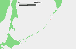
 Landsat view of Shiashkotan Island | |
 | |
| Geography | |
| Location | Sea of Okhotsk |
| Coordinates | 48°49′N 154°6′E |
| Archipelago | Kuril Islands |
| Area | 122 km2 (47 sq mi) |
| Highest elevation | 944 m (3097 ft) |
| Highest point | Pik Sinarka |
| Administration | |
Russia | |
| Demographics | |
| Population | 0 |
| Ethnic groups | Ainu (formerly) |

Geology
Shiashkotan is roughly dumbbell-shaped, formed by two volcanic islands joined together by a narrow landspit. The island has a total length of 25 kilometres (16 mi) with a width ranging from 9 kilometres (5.6 mi) at its widest point to 0.9 kilometres (0.56 mi) at its narrowest, and an area of 122 square kilometres (47 sq mi).[1] Both ends of the island are complex stratovolcanos, and landing is possible only on the sandy isthmus.
- Pik Sinarka (Russian: влк. Синарка; Japanese: 黒岳; Kurodake), which rises to 934 m (3,064 ft) above sea level occupies the northern end of the island, and is the island’s highest point. Historical eruptions have occurred at Sinarka during 1825–1750, 1846, 1855, and the last and largest from 1872 to 1878. To the east from this volcano is located interesting geothermal field - North-Western solfatara field with more than 100 fumaroles and several hot, geyser-like springs which erupt water up to 1.5 m high.
- Pik Kuntomintar -(Russian: влк.Китаио; Japanese: 北硫黄岳; Kitaiō-dake), occupies the southern end of the island. A central cone fills a 4-4.5 kilometer diameter caldera, and there is a second caldera on the west side which is breached to the west. The only known postglacial activity of Kuntomintar is continuous fulmarole activity near the east wall of the inner caldera and a nearby hot sulfur spring.
History
Shiashkotan was inhabited by the Ainu, who subsided off of hunting and fishing at the time of European contact. The island appears on an official map showing the territories of Matsumae Domain, a feudal domain of Edo period Japan dated 1644, and these holdings were officially confirmed by the Tokugawa shogunate in 1715. Subsequently, claimed by the Empire of Russia, sovereignty initially passed to Russia under the terms of the Treaty of Shimoda. During an eruption of 1872, Russian authorities recorded that 13 inhabitants died; however, when the island was returned to the Empire of Japan per the Treaty of Saint Petersburg (1875) along with the rest of the Kuril islands, no inhabitants remained as they had chosen to move north to Kamchatka, which remained under the Russian jurisdiction. The island was formerly administered as part of Shimushu District of Nemuro Subprefecture of Hokkaidō. In 1893, a settlement was attempted by nine members of the Chishima Protective Society led by Gunji Shigetada; however, when a ship called on the island a year later, five of the colonists had already died, and the remaining four were critically ill with beri-beri. After World War II, the island came under the control of the Soviet Union, and is now administered as part of the Sakhalin Oblast of the Russian Federation.
See also
Notes
- "International Kuril Island Project(IKIP)". University of Washington Fish Collection or the respective authors.
References
- "Sinarka". Global Volcanism Program. Smithsonian Institution. Retrieved 2021-06-25.
- "Kuntomintar". Global Volcanism Program. Smithsonian Institution. Retrieved 2021-06-25.
Further reading
- Gorshkov, G. S. Volcanism and the Upper Mantle Investigations in the Kurile Island Arc. Monographs in geoscience. New York: Plenum Press, 1970. ISBN 0-306-30407-4
- Krasheninnikov, Stepan Petrovich, and James Greive. The History of Kamtschatka and the Kurilski Islands, with the Countries Adjacent. Chicago: Quadrangle Books, 1963.
- Rees, David. The Soviet Seizure of the Kuriles. New York: Praeger, 1985. ISBN 0-03-002552-4
- Takahashi, Hideki, and Masahiro Ōhara. Biodiversity and Biogeography of the Kuril Islands and Sakhalin. Bulletin of the Hokkaido University Museum, no. 2-. Sapporo, Japan: Hokkaido University Museum, 2004.
External links
- "Oceandots". Archived from the original on December 23, 2010. Retrieved May 25, 2010.
{{cite web}}: CS1 maint: unfit URL (link)
На других языках
[de] Schiaschkotan
Schiaschkotan (russisch Остров Шиашкотан; jap. .mw-parser-output .Hani{font-size:110%}捨子古丹島, Shasukotan-tō) ist eine unbewohnte Vulkaninsel der Kurilen. Sie liegt 25 Kilometer südwestlich der Insel Charimkotan sowie 8 km südöstlich der Insel Ekarma und gehört administrativ zur russischen Oblast Sachalin.- [en] Shiashkotan
[es] Shiashkotan
Shiashkotan (en ruso, Шиашкотан, y en japonés, Shasukotan) es una isla rusa en el archipiélago de las Kuriles. Tiene una superficie de 122 km². Pertenece al grupo de las Kuriles septentrionales.[fr] Chiachkotan
L'île Chiachkotan (russe : Шиашкотан ; japonais : 捨子古丹島 ; Shasukotan, parfois Shasukotan-tō, est une île volcanique inhabitée située près du centre de la chaîne des îles Kouriles en mer d'Okhotsk, dans le nord-ouest de l'océan Pacifique. Elle est séparée d'Ekarma par le détroit d'Ekarma.[it] Šiaškotan
Šiaškotan (in russo Шиашкотан; in giapponese 捨子古丹島, Shasukotan-tō) è un'isola russa che fa parte dell'arcipelago delle Isole Curili ed è situata tra il Mare di Ochotsk e l'Oceano Pacifico settentrionale. Amministrativamente fa parte del Severo-Kuril'skij rajon dell'oblast' di Sachalin, nel Circondario federale dell'Estremo Oriente. Il suo nome viene dalla lingua ainu e significa "villaggio del kombu". L'isola è disabitata.[ru] Шиашкотан
Шиашкотан (на российской карте 1745-го года — Кривой[1]) — остров в Северной группе Большой гряды Курильских островов. Административно входит в Северо-Курильский городской округ Сахалинской области. В настоящее время необитаем. Коренными жителями острова были айны[2], в переводе с языка которых «сиас котан» означает «остров сивучей»[3]. Часть туземного населения погибла после извержения 1872 года, другая же часть переселилась на Камчатку после передачи всех Курил Японии в 1875 году. Попытки японской колонизации успехом не увенчались. В советское время на острове размещался гарнизон пограничников[4].Другой контент может иметь иную лицензию. Перед использованием материалов сайта WikiSort.org внимательно изучите правила лицензирования конкретных элементов наполнения сайта.
WikiSort.org - проект по пересортировке и дополнению контента Википедии