geo.wikisort.org - Island
Umara Island is an island in the Sea of Okhotsk on the south side of Odyan Bay.
Umara
Умара | |
|---|---|
Island | |
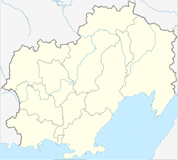
 Map of Odyan Bay | |
 Umara | |
| Coordinates: 59°9′10″N 151°57′14″E[1] | |
| Country | Russian Federation |
| Federal subject | Far Eastern Federal District |
| Oblast | Magadan Oblast |
| Elevation | 77 m (253 ft) |
Geography
The island is 0.9 km long and is separated from the northern shore of the Koni Peninsula by a 1 km wide sound. There is a monitoring site for seabirds on the island.[2]
Administratively this island is part of the Magadan Oblast.[3]
References
- GoogleEarth
- Pacific Seabirds. The Group. 2004. Retrieved 17 October 2012.
- Ostrov Umara / Magadanskaya Oblast
|
This Magadan Oblast location article is a stub. You can help Wikipedia by expanding it. |
На других языках
- [en] Umara Island
[it] Umara
Umara (in russo: Умара?) è un'isoletta russa che si trova nella parte orientale della baia del Tauj (Тауйская губа), nel Mare di Ochotsk, nell'Estremo Oriente russo.[ru] Умара
Умара — остров в восточной части Тауйской губы (залив Одян) в Охотском море возле северного побережья полуострова Кони, с которым соединяется каменистой косой во время максимальных отливов. Площадь 0,3 км².Текст в блоке "Читать" взят с сайта "Википедия" и доступен по лицензии Creative Commons Attribution-ShareAlike; в отдельных случаях могут действовать дополнительные условия.
Другой контент может иметь иную лицензию. Перед использованием материалов сайта WikiSort.org внимательно изучите правила лицензирования конкретных элементов наполнения сайта.
Другой контент может иметь иную лицензию. Перед использованием материалов сайта WikiSort.org внимательно изучите правила лицензирования конкретных элементов наполнения сайта.
2019-2026
WikiSort.org - проект по пересортировке и дополнению контента Википедии
WikiSort.org - проект по пересортировке и дополнению контента Википедии