geo.wikisort.org - Island
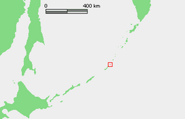
Ketoy (or Ketoi) (Russian: Кетой; Japanese 計吐夷島; Ketoi-tō) is an uninhabited volcanic island located in the centre of the Kuril Islands chain in the Sea of Okhotsk in the northwest Pacific Ocean. Its name is derived from the Ainu language for "skeleton" or "bad".
Native name: Кетой 計吐夷島 | |
|---|---|
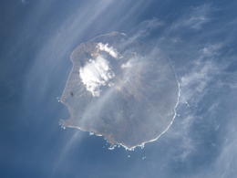 NASA picture of Ketoy Island | |
 | |
| Geography | |
| Location | Sea of Okhotsk |
| Coordinates | 47.35°N 152.475°E |
| Archipelago | Kuril Islands |
| Area | 73 km2 (28 sq mi) |
| Highest elevation | 1,172 m (3845 ft) |
| Highest point | Ketoy |
| Administration | |
Russia | |
| Demographics | |
| Population | 0 |
| Ethnic groups | Ainu (formerly) |
Geography
The shape of the island is almost circular: approximately 10 km in length by approximately 9 km in width, with an area of 71.25 square kilometres (27.51 sq mi) [1] The length of the coastline is 38.3 kilometers. Despite its relatively small area, the island has much landscape diversity, which is explained by its complex geomorphology, in which there are stratovolcanic cones, calderas, lava flows, volcanic plateaus, various valleys, high and steep coastal ledges, sea terraces, and rocky beaches. The steep cliffs ranging from 30 metres to 60 metres on the east and south sides with the west and north being taller. The beaches on the island consist of boulders and stones. The rivers and streams are numerous: mostly flowing to the south and east. The terrain is undulating and steep with numerous hills, rising to two main peaks:
The highest point is Mount Ketoy -(Russian: влк Кетой; Japanese 計吐夷岳; Ketoidake) with a height of 1,172 meters[2] to the east of the 1.5 km wide freshwater caldera lake. The lake is 110 meters deep, and is the source of the Stochny Creek, which flows into the Pacific Ocean; the surface of the lake is at an altitude of 667 meters. The waters of thermal springs at the lake contain strontium, which makes them potentially interesting for the metallurgical industry.
The second peak is Pallas -(Russian: влк Палласа; Japanese 白烟山; Shirokemuriyama) with a height of 993 meters in the center of the island, which is still an active volcano. A major eruption occurred from 1846 to 1847, with the last known eruption in 1960. Eruptions of uncertainty occurred in 2013 and 2018.[3] Pallas also has a caldera lake, Lake Glazok, about 300 meters wide and 40 meters deep, with acidic water.
History
Ketoy had no permanent habitation prior to European contact, but was visited in summer by the Ainu tribes from Rasshua for hunting. Members of the Russian expedition who visited the island in 1811, found the remains of a wooden cross with the word "God", which was presented as evidence of the gradual Christianization and Russification of the Ainu; however, a census in 1831 found no permanent inhabitants. Claimed by the Empire of Russia, sovereignty was passed to the Empire of Japan per the Treaty of Saint Petersburg along with the rest of the Kuril islands. The island was formerly administered as part of Shimushiro District of Nemuro Subprefecture of Hokkaidō. After World War II, the island came under the control of the Soviet Union, and is now administered as part of the Sakhalin Oblast of the Russian Federation.
See also
References
- "International Kuril Island Project(IKIP)". University of Washington Fish Collection or the respective authors. Archived from the original on 2012-10-06. Retrieved 2009-12-03.
- "Ketoi". Global Volcanism Program. Smithsonian Institution. Retrieved 2021-06-25.
- "Ketoi: Eruptive History". Global Volcanism Program. Smithsonian Institution. Retrieved 2021-06-25.
Further reading
- Gorshkov, G. S. Volcanism and the Upper Mantle Investigations in the Kurile Island Arc. Monographs in geoscience. New York: Plenum Press, 1970. ISBN 0-306-30407-4
- Krasheninnikov, Stepan Petrovich, and James Greive. The History of Kamtschatka and the Kurilski Islands, with the Countries Adjacent. Chicago: Quadrangle Books, 1963.
- Rees, David. The Soviet Seizure of the Kuriles. New York: Praeger, 1985. ISBN 0-03-002552-4
- Takahashi, Hideki, and Masahiro Ōhara. Biodiversity and Biogeography of the Kuril Islands and Sakhalin. Bulletin of the Hokkaido University Museum, no. 2-. Sapporo, Japan: Hokkaido University Museum, 2004.
External links
На других языках
[de] Ketoi
Ketoi (russisch Кетой; jap. .mw-parser-output .Hani{font-size:110%}計吐夷島, Ketoi-tō) ist eine unbewohnte Vulkaninsel im zentralen Bereich der Kurilen, etwa 19 Kilometer nordwestlich der Insel Simuschir gelegen. Die Insel gehört administrativ zur russischen Oblast Sachalin. Die Insel ist annähernd rund mit einem Durchmesser von etwa 12 Kilometer sowie einer Fläche von 73 km².- [en] Ketoy
[es] Ketoy
Ketoy (en ruso, Кетой, y en japonés, Ketoi) es una isla rusa en el archipiélago de las Kuriles. Tiene una superficie de 73 km². Pertenece al grupo de las Kuriles centrales.[fr] Ketoï
Ketoï, en russe Кетой, en japonais Ketoi-tō (計吐夷島?), est une île volcanique de Russie située dans l'océan Pacifique et faisant partie des îles Kouriles, entre les îles de Simouchir au sud-ouest et Rasshua au nord-est. Elle constitue le sommet émergé d'un stratovolcan et culmine à 1 172 mètres d'altitude.[it] Ketoj
Ketoj (in russo Кетой; in giapponese 計吐夷島, Ketoi-tō) è un'isola russa che fa parte dell'arcipelago delle Isole Curili ed è situata tra il Mare di Ochotsk e l'Oceano Pacifico settentrionale. Amministrativamente fa parte del Severo-Kuril'skij rajon dell'oblast' di Sachalin, nel Circondario federale dell'Estremo Oriente. Il suo nome viene dalla lingua ainu e significa "scheletro" o "cattivo". L'isola è disabitata.[ru] Кетой
Кетой (яп. 計吐夷, Кэтои; на российской карте 1745 года — Сюшевыполитъ[2]) — остров средней группы Большой гряды Курильских островов. Административно входит в Северо-Курильский городской округ Сахалинской области (с 1946 года). В настоящее время остров необитаем, хотя в прошлом определённую хозяйственную деятельность на нём осуществляли айны, в переводе с языка которых «китой» означает «травяной».[3] Отличается высоким коэффициентом ландшафтного разнообразия.[1]Другой контент может иметь иную лицензию. Перед использованием материалов сайта WikiSort.org внимательно изучите правила лицензирования конкретных элементов наполнения сайта.
WikiSort.org - проект по пересортировке и дополнению контента Википедии