geo.wikisort.org - Island
Kunashir Island (Russian: Кунаши́р, romanized: Kunashír; Japanese: 国後島, romanized: Kunashiri-tō; Ainu: クナシㇼ, romanized: Kuna=sir), possibly meaning Black Island or Grass Island in Ainu, is the southernmost island of the Kuril Islands archipelago. The island has been under Russian administration since the end of World War II, when Soviet forces took possession of the Kurils. It is claimed by Japan (see Kuril Islands dispute).
This article needs additional citations for verification. (December 2018) |
| Disputed island Native name: Ainu: クナシㇼ Other names: Russian: Кунаши́р; Japanese: 国後島 | |
|---|---|
 Kunashir is in the middle | |
 Kunashir Island Location of Kunashir Island  Kunashir Island Kunashir Island (Russia) | |
| Geography | |
| Location | Sea of Okhotsk |
| Coordinates | 44°07′N 145°51′E |
| Archipelago | Kuril Islands |
| Area | 1,490 square kilometres (580 sq mi) |
| Length | 123 kilometres (76 mi) |
| Width | from 4 kilometres (2.5 mi) to 30 kilometres (19 mi) |
| Highest point |
|
| Administered by | |
| Federal subject | Sakhalin Oblast |
| District | Yuzhno-Kurilsky |
| Claimed by | |
| Prefecture | Hokkaido |
| Subprefecture | Nemuro |
| Demographics | |
| Population | approx. 7000 (as of 2007) |
Geography
Kunashir lies between the straits of Kunashir Island, Catherine, Izmena, and South Kuril. Kunashir Island is visible from the nearby Japanese island of Hokkaido, from which it is separated by the Nemuro Strait.
- Area: 1,490 km2 (580 sq mi)
- Length: 123 km (76 mi)
- Width: 4–30 km (2.5–18.6 mi)
Kunashir Island is formed by four volcanoes which were separate islands but have since joined together by low-lying areas with lakes and hot springs. All these volcanoes are still active: Tyatya (1,819 m (5,968 ft)), Smirnov, Mendeleev (Rausu-yama), and Golovnin (Tomari-yama).[1] The island is made up of volcanic and crystalline rocks.
 Cape Stolbchaty on the western side of the island
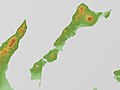 Relief map
 View of Kunashir from the Rausu Kunashiri Observatory Deck


Environment
The climate is humid continental with very heavy precipitation especially in the autumn and a strong seasonal lag with maximum temperatures in August and September. The vegetation mostly consists of spruce, pine, fir, and mixed deciduous forests with lianas and Kuril bamboo underbrush. The mountains are covered with birch and Siberian Dwarf Pine scrub, herbaceous flowers or bare rocks. Tree cores of century-old oaks (Quercus crispula) were found in July 2001 on Kunashiri Island.[2]
Important Bird Area
Kunashir, along with the neighbouring Lesser Kuril Chain of smaller islands, has been recognised as an Important Bird Area (IBA) by BirdLife International as the island supports populations of various threatened bird species, including many waterbirds, seabirds and waders.[3]
History
The Ainu are the original natives of the island until the Yamato Japanese colonists expanded northward, with Matsumae clan established Kunashir fishery and trading site (国後場所,Kunashiri-basho) in 1754.[4] Administration office of the fishery and trading site located in Tomari (now Golovnino). Area of Kunashir fishery and trading site was consisted of Kunashir, Iturup and Urup islands.
In 1789 Kunashir Island was one of the settings of the Menashi-Kunashiri Battle in which native Ainu revolted against Yamato Japanese tradespeople and colonists.
Russian navigator Vasily Golovnin attempted to map and explore the island in 1811, but was apprehended by Japanese authorities and spent two years in prison.

On September 1, 1945, or one day before the surrender documents of World War II were signed on September 2, 1945, in accordance with understandings reached at the Yalta Conference, the Soviet Union invaded and occupied the Kuril Islands. This occurred after the Soviet Union renounced the Soviet–Japanese Neutrality Pact signed in April 1941, and declared war on Japan on August 9, 1945 (formally, the pact itself remained in effect until April 13, 1946). Although Japan agreed after deliberations to cede its claims to "the Kurile Islands" as part of the Treaty of San Francisco in 1951, the Japanese government has claimed since the mid-1950s that the southern islands were not part of the ceded Kuril Islands.
Settlements
The largest settlement on Kunashir Island is Yuzhno-Kurilsk, administrative center of Yuzhno-Kurilsky District.
Economy
The primary economic activity is the fishing industry. The island has a port next to Yuzhno-Kurilsk. Kunashir Island enjoys a Mendeleevskaya GeoPP geothermal power plant with the capacity of 1.8 MW.[5]
Transport
The island is served by Mendeleyevo Airport.
Population
After the 1994 earthquake, about one-third of Kunashir Island's population left and did not return. By 2002, the island's population was approximately 7,800. The total population of the disputed Kuril islands at that time was approximately 17,000.[6]


See also
- Kuril Islands dispute
References
Notes
- Volcanoes
- Jacoby, G.; Solomina, O.; Frank, D.; Eremenko, N.; D'Arrigo, R. (2004). "Kunashir (Kuriles) Oak 400-year reconstruction of temperature and relation to the Pacific Decadal Oscillation". Palaeogeography, Palaeoclimatology, Palaeoecology. 209 (1–4): 303–311. Bibcode:2004PPP...209..303J. doi:10.1016/j.palaeo.2004.02.015.
- "Lesser Kuril Ridge and Kunashir Island". BirdLife Data Zone. BirdLife International. 2021. Retrieved 7 February 2021.
- 戸祭由美夫『絵図に見る幕末の北辺防備:五稜郭と城郭・陣屋・台場』古今書院、2018年、71頁(Tomatsuri Yumio, Japanese Military Architectures around the Coast of Yezo Province in the Nineteenth Century, (Tokyo: Kokon Shoin Publishers Ltd), p.71. ISBN 9784772220248)
- "2007 Survey of Energy Resources" (PDF). World Energy Council 2007. 2007. Archived from the original (PDF) on 9 April 2011. Retrieved 23 January 2011.
- Yuzhno-Kurilsk Journal; Between Russia and Japan, a Pacific Tug of War — The New York Times, 2002
General references
- Geographic data at the Wayback Machine (archived December 23, 2010)
- Flights to Kunashir Island banned
External links
На других языках
[de] Kunaschir
Kunaschir (russisch Кунашир; japanisch: .mw-parser-output .Hani{font-size:110%}国後島, Kunashiri-tō) ist eine Insel des Kurilen-Archipels. Sie gehört zu Russland, wird aber von Japan als Teil der Unterpräfektur Nemuro, Hokkaidō beansprucht.- [en] Kunashir Island
[es] Kunashir
Kunashir (en japonés: 国後島 Kunashiri-tō, y en ruso: Кунашир) es una isla controlada por Rusia en el archipiélago de las Kuriles. Tiene una superficie de 1.490 km². Pertenece al grupo de las Kuriles meridionales. Japón mantiene con Rusia una disputa por esta isla, ya que la reclama desde antaño.[fr] Kounachir
Kounachir (en russe : Кунашир, en 国後島 (Kunashiri-tō?)) est une île de l'archipel des Kouriles, située dans l'océan Pacifique entre la péninsule du Kamtchatka et l'île japonaise d'Hokkaidō. Kounachir est une île administrée par la Russie et rattachée à l'oblast de Sakhaline. Elle fait partie des îles méridionales revendiquées par le Japon (Territoires du Nord (北方領土, hoppô ryôdo?)).[it] Kunašir
Kunašir (in russo: Кунашир?; in giapponese: 国後島, Kunashiri-tō; che significa "isola nera" o "isola d'erba" in Lingua ainu) è la più meridionale delle isole Curili controllate dalla Russia e rivendicate dal Giappone. È situata nel Mare di Ochotsk. Amministrativamente fa parte del Južno-Kuril'skij rajon dell'oblast' di Sachalin, nel Circondario federale dell'Estremo Oriente.[ru] Кунашир
Кунаши́р (айн. Кунашири — Чёрный остров, яп. 国後島 Кунасири-то, на российской карте 1745 года — Коносиръ[2]) — самый южный остров Большой гряды Курильских островов. Согласно федеративному устройству России входит в Сахалинскую область в составе Южно-Курильского района в рамках административно-территориального устройства области и в составе Южно-Курильского городского округа в рамках муниципального устройства в области. Принадлежность острова России оспаривает Япония, которая рассматривает его как часть своего округа Нэмуро префектуры Хоккайдо[3][4][5].Другой контент может иметь иную лицензию. Перед использованием материалов сайта WikiSort.org внимательно изучите правила лицензирования конкретных элементов наполнения сайта.
WikiSort.org - проект по пересортировке и дополнению контента Википедии