geo.wikisort.org - Island
Antsiferov Island (Russian: Остров Анциферова; also known as Shirinki Russian: Ширинки Japanese 志林規島; Shirinki-tō) is an uninhabited volcanic island located in the northern Kuril Islands chain in the Sea of Okhotsk in the northwest Pacific Ocean. Its former Japanese name is derived from the Ainu language for "place of tall waves". Its nearest neighbor is Paramushir, located 15 km away across the Luzhin Strait. It is currently named for the cossack explorer Danila Antsiferov, who first described it along with other northern Kuril islands in the early eighteenth century.
Native name: Чиринкотан 志林規島 / | |
|---|---|
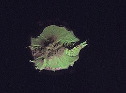
 NASA picture of Antsiferov from space | |
 | |
| Geography | |
| Location | Sea of Okhotsk |
| Coordinates | 50.20°N 154.98°E |
| Archipelago | Kuril Islands |
| Area | 7 km2 (2.7 sq mi) |
| Highest elevation | 761 m (2497 ft) |
| Administration | |
Russia | |
| Demographics | |
| Population | 0 |
| Ethnic groups | Ainu (formerly) |
Geology
Antsiferov is a roughly circular island with an area of 6 km2 [1] and is part of a spur range extending to the west of the main Kuril islands arc. The island is a stratovolcano with a diameter of 4.25 km and with a central peak (Japanese 蓮華岳; Renge-dake) with a height of 761 metres which is marked by a caldera which is 0.75 kilometre in diameter, which is breached to the south. Two lava domes are located near the walls of the breach, which appear to be of relatively recent origin, although no volcanic eruptions have been observed on Antsiferov in modern times. Much of the island is covered by pumice from pyroclastic-fall deposits.
Fauna
The southern end of Antsiferov is the site of one of five major Steller sea lion breeding rookeries (about 600 animals) on the Kuril Islands. Because of the absence of terrestrial predators, it is also the home of very dense colonies of northern fulmars and tufted puffins which nest in the hummocks along its slopes. Cliff-dwelling birds, such as kittiwakes and thick-billed murres are also abundant.
History
Antsiferov had no permanent habitation prior to European contact, but was visited in summer by the Ainu tribes for hunting. Claimed by the Empire of Russia, sovereignty was passed to the Empire of Japan per the Treaty of Saint Petersburg along with the rest of the Kuril islands. The island was formerly administered as part of Shimushu District of Nemuro Subprefecture of Hokkaidō. After World War II, the island came under the control of the Soviet Union, and is now administered as part of the Sakhalin Oblast of the Russian Federation. The island is now part of a wildlife refuge, and approach within 20 km by fishing vessels is prohibited.
See also
References
- "International Kuril Island Project(IKIP)". University of Washington Fish Collection or the respective authors. Archived from the original on 2012-10-06. Retrieved 2009-11-27.
- "Shirinki". Global Volcanism Program. Smithsonian Institution. Retrieved 2021-06-25.
Further reading
- Gorshkov, G. S. Volcanism and the Upper Mantle Investigations in the Kurile Island Arc. Monographs in geoscience. New York: Plenum Press, 1970. ISBN 0-306-30407-4
- Krasheninnikov, Stepan Petrovich, and James Greive. The History of Kamtschatka and the Kurilski Islands, with the Countries Adjacent. Chicago: Quadrangle Books, 1963.
- Rees, David. The Soviet Seizure of the Kuriles. New York: Praeger, 1985. ISBN 0-03-002552-4
- Takahashi, Hideki, and Masahiro Ōhara. Biodiversity and Biogeography of the Kuril Islands and Sakhalin. Bulletin of the Hokkaido University Museum, no. 2-. Sapporo, Japan: Hokkaido University Museum, 2004.
На других языках
[de] Anziferow-Insel
Die Anziferow-Insel, auch Schirinki (russisch остров Анциферова/ ostrow Anziferowa, jap. .mw-parser-output .Hani{font-size:110%}志林規島, Shirinki-tō) ist eine zu Russland gehörende Vulkaninsel der nördlichen Kurilengruppe.- [en] Antsiferov Island
[es] Antsíferov
La isla de Antsíferov o Antsíferova (en ruso, Остров Анциферова y en japonés, Shirinki) es una isla rusa en el archipiélago de las Kuriles. Tiene una superficie de 7 km². Pertenece al grupo de las Kuriles septentrionales.[fr] Antsiferov (île)
Antsiferov est une île inhabitée de l'archipel des Kouriles dans la mer d'Okhotsk.[it] Anciferov
L'isola di Anciferov (in russo: Анциферова?; conosciuta anche come Širinki, in russo Ширинки; in giapponese 志林規島, Shirinki-tō) è un'isola russa che fa parte dell'arcipelago delle Isole Curili ed è situata nel Mare di Ochotsk. Amministrativamente fa parte del Severo-Kuril'skij rajon dell'oblast' di Sachalin, nel Circondario federale dell'Estremo Oriente. Il suo antico nome giapponese deriva dalla lingua ainu e significa "luogo delle onde alte". L'isola è disabitata.[ru] Остров Анциферова
Остров Анциферова (до 1952 года[1] — Ширинки[2], яп. 志林規島 Сиринки-то; на российской карте 1745-го года — Дилковъ[3], французской 1750-го года — Dilkov[4]) — остров северной группы Большой гряды Курильских островов. Административно остров входит в Северо-Курильский городской округ Сахалинской области (с 1946 года). В настоящее время необитаем, хотя ранее на него регулярно наведывались для охоты и рыболовства айны.Другой контент может иметь иную лицензию. Перед использованием материалов сайта WikiSort.org внимательно изучите правила лицензирования конкретных элементов наполнения сайта.
WikiSort.org - проект по пересортировке и дополнению контента Википедии