geo.wikisort.org - Island
Kharimkotan (Russian: Харимкотан); Japanese 春牟古丹島; Harimukotan-tō, alternatively Harumukotan-tō or 加林古丹島; Karinkotan-tō) is an uninhabited volcanic island located 15 km (9 mi) from Onekotan near the northern end of the Kuril Islands chain in the Sea of Okhotsk in the northwest Pacific Ocean. Its name is derived from the Ainu language, from “village of many Cardiocrinum”.
Native name: Харимкотан 春牟古丹島 | |
|---|---|
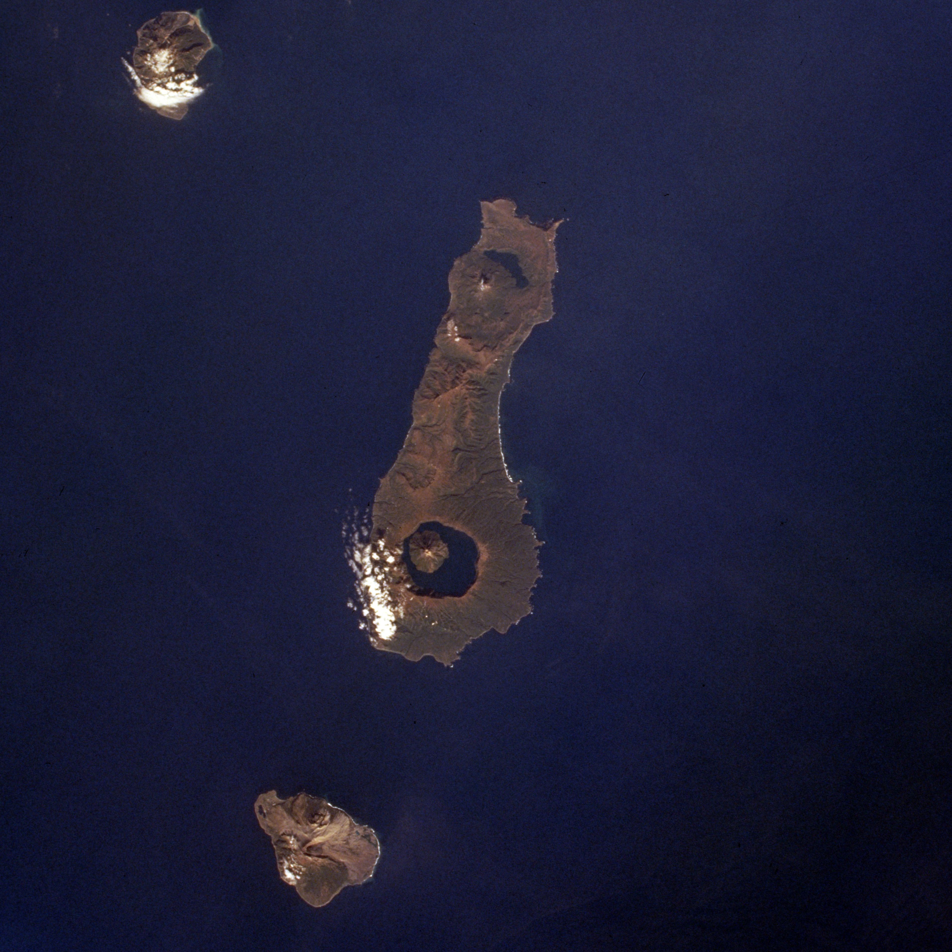
 Wintertime view of Kharimkotan Island | |
 | |
| Geography | |
| Location | Sea of Okhotsk |
| Coordinates | 49.12°N 154.508°E |
| Archipelago | Kuril Islands |
| Area | 68 km2 (26 sq mi) |
| Highest elevation | 1,145 m (3757 ft) |
| Highest point | Pik Severgin |
| Administration | |
Russia | |
| Demographics | |
| Population | 0 |
| Ethnic groups | Ainu (formerly) |
Geology
Kharimkotan is roughly oval, measuring 8 kilometres (5.0 mi) by 12 kilometres (7.5 mi) with an area of 68 km2 (26 sq mi).[1] The landscapes of the island are quite diverse; however, a significant part of the island's surface is covered with fine yellow ash, resembling desert dunes. On the north-western cape are the ruins of an Ainu village and in the north of the island, on the shore of Severgin Bay, is the abandoned settlement of Severgino. There are a number of small freshwater lakes.
Kharimkotan is separated by the Sixth Kuril Strait from Onekotan, located 15 kilometers to the northeast, and by the Severgin Strait from Shiashkotan, located 29 kilometers to the south-west. There are no convenient anchorage sites.
The island consists of a dormant stratovolcano, Pik Severgin -(Russian: влк.Севергина; Japanese 春牟古丹岳; Harikotan-dake), which rises to 1,157 m (3,796 ft) above sea level. The peak is marked by two horseshoe shaped volcanic craters created by the collapse of the volcano's upper slopes. Other evidence of the collapse can be seen on the peninsulas to the east and northwest which were formed by the debris. The volcano has erupted occasionally from the 18th century onwards, with the last recorded eruption in 1933 sending volcanic ash as far away as Paramushir. The collapse of the cone resulted in a debris-avalanche which subsequently caused a tsunami, which killed two people on Pamamushir. The path on which the debris took is visible on satellite imagery.
History
Kharimkotan was inhabited by the Ainu at the time of European contact. The inhabitants subsisted by growing the edible bulbs of the Cardiocrinum, as well as fishing and hunting. The island appears on an official map showing the territories of Matsumae Domain, a feudal domain of Edo period Japan dated 1644, and these holdings were officially confirmed by the Tokugawa shogunate in 1715. However, by 1736 the Ainu adopted Russian Orthodoxy and were taxed as Russian subjects by the Empire of Russia. In 1811, it was reported that most could speak the Russian language and had adopted Russian names. In 1855, sovereignty under Russia was recognised by the terms of the Treaty of Shimoda, but the island was transferred to the Empire of Japan per the Treaty of Saint Petersburg (1875) along with the rest of the Kuril islands. In 1884, the Ainu on Kharimkotan were resettled by the Japanese authorities to Shikotan. The island was formerly administered as part of Shimushu District of Nemuro Subprefecture of Hokkaidō. In January 1933, a Japanese settlement was destroyed by an eruption of the volcano, and the settlement was abandoned by the Japanese. After World War II, the island came under the control of the Soviet Union, and is now administered as part of the Sakhalin Oblast of the Russian Federation.
See also
Notes
- "International Kuril Island Project(IKIP)". University of Washington Fish Collection or the respective authors. Archived from the original on 2012-10-06. Retrieved 2010-05-23.
References
- "Kharimkotan". Global Volcanism Program. Smithsonian Institution.
Further reading
- Gorshkov, G. S. Volcanism and the Upper Mantle Investigations in the Kurile Island Arc. Monographs in geoscience. New York: Plenum Press, 1970. ISBN 0-306-30407-4
- Krasheninnikov, Stepan Petrovich, and James Greive. The History of Kamtschatka and the Kurilski Islands, with the Countries Adjacent. Chicago: Quadrangle Books, 1963.
- Rees, David. The Soviet Seizure of the Kuriles. New York: Praeger, 1985. ISBN 0-03-002552-4
- Takahashi, Hideki, and Masahiro Ōhara. Biodiversity and Biogeography of the Kuril Islands and Sakhalin. Bulletin of the Hokkaido University Museum, no. 2-. Sapporo, Japan: Hokkaido University Museum, 2004.
External links
- Oceandots at the Wayback Machine (archived December 23, 2010)
На других языках
[de] Charimkotan
Charimkotan (russisch Харимкотан, jap. .mw-parser-output .Hani{font-size:110%}春牟古丹島, Harimukotan-tō; Ainu für Land der Lilien) ist der Name einer zu Russland gehörenden Vulkaninsel in der Gruppe der Kurilen, welche sich 13 Kilometer südwestlich von Onekotan und nordöstlich von Ekarma und Schiaschkotan befindet. Von den beiden letztgenannten Inseln durch die Krenizyn-Straße getrennt hat Charimkotan einen Durchmesser von acht bis dreizehn Kilometer und eine Fläche von 68 km².- [en] Kharimkotan
[es] Jarimkotan
Jarimkotan (en ruso, Харимкотан, y en japonés, Harimukotan) es una isla rusa en el archipiélago de las Kuriles. Tiene una superficie de 68 km². Pertenece al grupo de las Kuriles septentrionales.[fr] Kharimkotan
Kharimkotan (russe : Харимкотан) est une île volcanique des îles Kouriles culminant à 1 157 m.[it] Charimkotan
Charimkotan (in russo Харимкотан; in giapponese 春牟古丹島, Harimukotan-tō o 加林古丹, Karinkotan-tō) è un'isola russa che fa parte dell'arcipelago delle Isole Curili ed è situata tra il Mare di Ochotsk e l'Oceano Pacifico settentrionale. Amministrativamente fa parte del Severo-Kuril'skij rajon dell'oblast' di Sachalin, nel Circondario federale dell'Estremo Oriente. Il suo nome viene dalla lingua ainu e significa «villaggio dei molti Cardiocrinum». L'isola è disabitata.[ru] Харимкотан
Харимкотан (на «чертеже» И. Козыревского 1726 г. Арау-макутан[2]; на российской карте 1745-го года — Красногорскъ[3]) — остров северной группы Большой гряды Курильских островов. Административно входит в Северо-Курильский городской округ Сахалинской области. В настоящее время остров необитаем, хотя в прошлом определённую хозяйственную деятельность на нём осуществляли айны, которые здесь проживали до 1875 года[4], в переводе с языка которых фраза «хар ум котан» означает «саранный остров» или «остров лилий»[5].Другой контент может иметь иную лицензию. Перед использованием материалов сайта WikiSort.org внимательно изучите правила лицензирования конкретных элементов наполнения сайта.
WikiSort.org - проект по пересортировке и дополнению контента Википедии