geo.wikisort.org - Island
Atlasov Island, known in Russian as Ostrov Atlasova (Остров Атласова), or in Japanese as Araido (阿頼度島), is the northernmost island and volcano and also the highest volcano of the Kuril islands, part of the Sakhalin Oblast in Russia. The Russian name is sometimes rendered in English as Atlasova Island. Other names for the island include Uyakhuzhach, Oyakoba and Alaid, the name of the volcano on the island.
This article needs additional citations for verification. (March 2012) |
| Atlasov | |
|---|---|
| Alaid | |
 | |
| Highest point | |
| Elevation | 2,285 m (7,497 ft)[1] |
| Prominence | 2,285 m (7,497 ft)[1] |
| Listing | Ultra |
| Coordinates | 50°51′39″N 155°33′51″E[2] |
| Geography | |
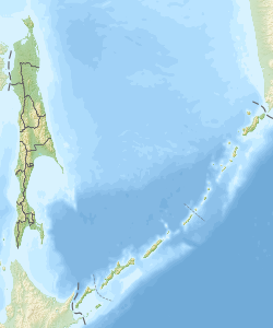
 Atlasov Kuril Islands, Russia | |
| Geology | |
| Mountain type | Stratovolcano |
| Last eruption | 2018 |
The island is named after Vladimir Atlasov, a 17th-century Russian explorer who incorporated the nearby Kamchatka Peninsula into Russia. It is essentially the cone of the submarine volcano Vulkan Alaid protruding above the Sea of Okhotsk to a height of 2,285 metres (7,497 feet). The island has an area of 119 square kilometres (46 square miles), but is currently uninhabited. Numerous pyroclastic cones dot the lower flanks of basaltic to basaltic andesite volcano, particularly on the NW and SE sides, including an offshore cone formed during the 1933–34 eruption.[1]

Its near perfect shape gave rise to many legends about the volcano among the peoples of the region, such as the Itelmens and Kuril Ainu. The Russian scientist Stepan Krasheninnikov was told the story that it was once a mountain in Kamchatka, but the neighbouring mountains became jealous of its beauty and exiled it to the sea, leaving behind Kurile Lake in southern Kamchatka. Geographically, this story is not without evidence, as after the last Ice Age most of the icecaps melted, raising the world's water level, and possibly submerging a landbridge to the volcano.[citation needed] Following the transfer of the Kuril Islands to Japan by the Treaty of St Petersburg, 1875, Oyakoba as it is called by the Japanese, became the northernmost island of the empire and subject of much aesthetic praise, described in haiku, ukiyo-e, etc.[citation needed] Ito Osamu (1926) described it as more exquisitely shaped than Mount Fuji.[citation needed]
Administratively this island belongs to the Sakhalin Oblast of the Russian Federation.
See also
- List of islands of Russia
- List of volcanoes in Russia
- List of ultras of Northeast Asia
References
- "Alaid". Global Volcanism Program. Smithsonian Institution.
- "Russia: Kamchatka and the Russian Pacific Islands Ultra-Prominence Page" Peaklist.org. Listed here as "Alaid V.". Retrieved 2011-11-27.
External links
- The Russian Kuril Islands Expedition to Atlasov
- Sakhalin Oblast[permanent dead link]
- "Vulkan Alaid, Russia" on Peakbagger
На других языках
[de] Atlassow-Insel
Die Atlassow-Insel (russisch остров Атласова .mw-parser-output .Latn{font-family:"Akzidenz Grotesk","Arial","Avant Garde Gothic","Calibri","Futura","Geneva","Gill Sans","Helvetica","Lucida Grande","Lucida Sans Unicode","Lucida Grande","Stone Sans","Tahoma","Trebuchet","Univers","Verdana"}ostrow Atlassowa; auch Atlasowinsel, ostrov Atlasova, Atlasov Island, Uyakhuzhach, Araito, Alaid oder jap. .mw-parser-output .Hani{font-size:110%}阿頼度島, Araido-tō) ist die nördlichste Insel der Kurilen und Teil der Oblast Sachalin in Russland.- [en] Atlasov Island
[es] Isla de Atlasov
Error de Lua en Módulo:Ficha en la línea 379: attempt to concatenate field 'claseimagen' (a nil value). La isla de Atlásov o Atlásova (en ruso: Остров Атласова); en japonés, Oyakoba es una pequeña isla deshabitada rusa del archipiélago de las islas Kuriles localizada en aguas del mar de Ojotsk, frente a la punta meridional de la península de Kamchatka. Administrativamente pertenece al óblast de Sajalín de la Federación Rusa. Tiene una superficie de 119 km² y pertenece al grupo de las Kuriles septentrionales.[fr] Île Atlassov
L'île Atlassov (en russe : Остров Атласова, en japonais : 阿頼度島, Araido) est une île volcanique, la plus septentrionale des îles Kouriles, dans l'oblast de Sakhaline, à l'est de la Russie. L'île figure parfois sous les noms d'Ouïakhoujatch, d'Oyakoba et d'Alaïd.[it] Atlasov (isola)
L'isola di Atlasov (russo Остров Атласова, Ostrov Atlasova; giapponese 阿頼度島, Araido-tō), è un'isola formata da un vulcano. È la più settentrionale dell'arcipelago delle isole Curili, e il vulcano è anche il più alto dell'arcipelago. Fa parte della regione russa dell'Oblast' di Sachalin. Viene anche conosciuta con i nomi di: Ujachužač, Oyakoba e Alaid, il nome del vulcano. L'isola è disabitata.[ru] Остров Атласова
Остров Атла́сова (до 1950-х годов Алаид[2], яп. 阿頼度島 Араидото; на российской карте 1745-го года — Анфиногенъ[3]) — самый северный остров Большой гряды Курильских островов. Также это самый высокий из всех Курильских островов. Является высочайшим островом России и 50-м в мире. Административно входит в Северо-Курильский городской округ[4] Сахалинской области (с 1946 года).Другой контент может иметь иную лицензию. Перед использованием материалов сайта WikiSort.org внимательно изучите правила лицензирования конкретных элементов наполнения сайта.
WikiSort.org - проект по пересортировке и дополнению контента Википедии