geo.wikisort.org - Mountains
Tyatya (Russian: Тятя, also spelled Tiatia and known as Chachadake (爺爺岳) in Japanese) is a volcano located in the northeastern part of Kunashir Island, Kuril Islands, Russia. It is the highest peak on the island with an elevation of 1,819 metres (5,968 ft).[1] Tyatya is one of the finest examples anywhere in the world of a somma volcano, a stratovolcano whose summit has collapsed to form a caldera which has then been mostly refilled by a new, younger volcanic cone which rises above the caldera rim.[1]

| Tyatya | |
|---|---|
| Chachadake | |
 Tyatya in 2010, viewed from the south-west | |
| Highest point | |
| Elevation | 1,822 m (5,978 ft)[1] |
| Prominence | 1,822 m (5,978 ft)[2] |
| Listing | Ultra |
| Coordinates | 44°21′3″N 146°15′23″E[1] |
| Geography | |
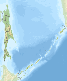 Tyatya Kunashir, Kuril Islands, Russia | |
| Geology | |
| Mountain type | Stratovolcano / somma volcano |
| Last eruption | June 1981[1] |
See also
- List of volcanoes in Russia
- List of ultras of Northeast Asia
References
- "Tiatia". Global Volcanism Program. Smithsonian Institution.
- "Russia: Kamchatka and the Russian Pacific Islands" Peaklist.org. Retrieved 2013-03-23.
External links
Wikimedia Commons has media related to Tyatya.
- Chachadake (Tiatia): Global Volcanism Program - Smithsonian Institution
- Chachadake - Japan Meteorological Agency (in Japanese)
- "Chachadake: National catalogue of the active volcanoes in Japan" (PDF). - Japan Meteorological Agency
- Chacha Dake (Tyatya) - Geological Survey of Japan
This Sakhalin Oblast location article is a stub. You can help Wikipedia by expanding it. |
На других языках
- [en] Tyatya
[fr] Tyatya
Le Tyatya, Tiatia ou Tsiatsia, en russe : Тятя, est un volcan de Russie situé dans les îles Kouriles, sur Kounachir dont il est le point culminant avec 1 819 mètres d'altitude.[ru] Тятя
Тя́тя (айнское Чача-Нупури, буквально — «отец-гора» яп. 爺爺岳 тятя дакэ) — действующий вулкан на острове Кунашир Большой Курильской гряды, на территории Курильского заповедника.Текст в блоке "Читать" взят с сайта "Википедия" и доступен по лицензии Creative Commons Attribution-ShareAlike; в отдельных случаях могут действовать дополнительные условия.
Другой контент может иметь иную лицензию. Перед использованием материалов сайта WikiSort.org внимательно изучите правила лицензирования конкретных элементов наполнения сайта.
Другой контент может иметь иную лицензию. Перед использованием материалов сайта WikiSort.org внимательно изучите правила лицензирования конкретных элементов наполнения сайта.
2019-2026
WikiSort.org - проект по пересортировке и дополнению контента Википедии
WikiSort.org - проект по пересортировке и дополнению контента Википедии