geo.wikisort.org - Island
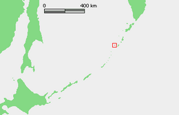
Chirinkotan (Russian: Чиринкотан; Japanese 知林古丹島; Chirinkotan-tō) is an uninhabited volcanic island located in the centre of the Kuril Islands chain in the Sea of Okhotsk in the northwest Pacific Ocean. Its name is derived from the Ainu language for "mudslide".[citation needed] It is located 3 kilometres (1.9 miles) west of Ekarma, its nearest neighbor.
Native name: Чиринкотан 知林古丹島 | |
|---|---|
 NASA picture of Chirinkotan Island | |
 | |
| Geography | |
| Location | Sea of Okhotsk |
| Coordinates | 48.98°N 153.48°E |
| Archipelago | Kuril Islands |
| Area | 6 km2 (2.3 sq mi) |
| Highest elevation | 742 m (2434 ft) |
| Highest point | Masaochi Peak volcano (last eruption 2013 to 2014) |
| Administration | |
Russia | |
| Demographics | |
| Population | 0 |
Geology
Chirinkotan is at the far end of a volcanic chain extending nearly 50 km west of the central part of the main Kuril Islands arc. The island is the top of a partially submerged stratovolcano rising approximately 3,000 metres (9,800 feet) from the floor of the Sea of Okhotsk, and is roughly circular with an area of 6 square kilometres (2.3 square miles).[1] The island's highest point ("Masaochi" in Ainu) is 742 metres (2,434 feet) high, and is still an active volcano with major eruptions recorded in 1760, 1884, 1900, 1979, 1986, 2004, and 2013. Reports of a 1955 eruption are unconfirmed. The caldera is approximately one kilometre (0.62 miles) wide, with a depth of 300 to 400 metres (980–1,310 feet), and is breached on its south-east side. The shores of the island are steep cliffs, making landing by small boat impossible.
History
Chirinkotan has had no permanent habitation. Claimed by the Empire of Russia, sovereignty was passed to the Empire of Japan per the Treaty of Saint Petersburg along with the rest of the Kuril Islands. The island was formerly administered as part of Shumushu District of Nemuro Subprefecture of Hokkaidō. After World War II, the island came under the control of the Soviet Union, and is now administered as part of the Sakhalin Oblast of the Russian Federation.
Fauna
In the spring and early summer crested, whiskered, and parakeet auklet nest on the island.[2]
See also
References
- "Chirinkotan". Global Volcanism Program. Smithsonian Institution.
- "Oceandots entry". Archived from the original on December 23, 2010. Retrieved December 5, 2009.
{{cite web}}: CS1 maint: bot: original URL status unknown (link)
External links
- Sakhalin Oblast[permanent dead link]
Further reading
- Gorshkov, G. S. Volcanism and the Upper Mantle Investigations in the Kurile Island Arc. Monographs in geoscience. New York: Plenum Press, 1970. ISBN 0-306-30407-4
- Krasheninnikov, Stepan Petrovich, and James Greive. The History of Kamtschatka and the Kurilski Islands, with the Countries Adjacent. Chicago: Quadrangle Books, 1963.
- Rees, David. The Soviet Seizure of the Kuriles. New York: Praeger, 1985. ISBN 0-03-002552-4
- Takahashi, Hideki, and Masahiro Ōhara. Biodiversity and Biogeography of the Kuril Islands and Sakhalin. Bulletin of the Hokkaido University Museum, no. 2-. Sapporo, Japan: Hokkaido University Museum, 2004.
Notes
- "International Kuril Island Project(IKIP)". University of Washington Fish Collection or the respective authors. Archived from the original on 2012-10-06. Retrieved 2009-12-05.
- Kondratyev, A. Y., Litvinenko, N. M., Shibaev, Y. V., Vyatkin, P. S., & Kondratyeva, L. F. (2000). "The breeding seabirds of the Russian Far East". Seabirds of the Russian Far East, 37-81.
This Sakhalin Oblast location article is a stub. You can help Wikipedia by expanding it. |
На других языках
[de] Tschirinkotan
Tschirinkotan (russisch Остров Чиринкотан; jap. .mw-parser-output .Hani{font-size:110%}越渇磨島, Chirinkotan-tō) ist eine Vulkaninsel der russischen Kurilen. Tschirinkotan hat eine Fläche von 9 km² und liegt circa 30 Kilometer westlich von Ekarma, einer weiteren Kurileninsel vulkanischen Ursprungs.- [en] Chirinkotan
[es] Chirinkotan
Chirinkotan (en ruso, Чиринкотан, y en japonés, Chirinkotan) es una isla rusa en el archipiélago de las Kuriles. Tiene una superficie de 6 km². Pertenece al grupo de las Kuriles septentrionales.[fr] Tchirinkotan
Tchirinkotan, en russe Ostrov Tchirinkotan, Остров Чиринкотан[1], en japonais Chirinkotan-tō, 知林古丹島, est une île volcanique inhabitée de Russie située dans les îles Kouriles.[it] Čirinkotan
Čirinkotan (in russo Чиринкотан; in giapponese 知林古丹島, Chirinkotan-tō) è un'isola russa che fa parte dell'arcipelago delle Isole Curili ed è situata nel Mare di Ochotsk. Amministrativamente fa parte del Severo-Kuril'skij rajon dell'oblast' di Sachalin, nel Circondario federale dell'Estremo Oriente. Il suo nome viene dalla lingua ainu e significa "valanga di fango". L'isola è disabitata.[ru] Чиринкотан
Чиринкотан (на российской карте 1745-го года — Лаупсатъ[1], на французской 1750-го года — Laoupsat[2]) — вулканический по происхождению остров северной группы Большой гряды Курильских островов. Административно входит в Северо-Курильский городской округ Сахалинской области (с 1946 года). До 1875 года определённую хозяйственную деятельность на острове осуществляли айны,[3] в переводе с языка которых «чирин котан» означает «очень маленький остров»[4].Другой контент может иметь иную лицензию. Перед использованием материалов сайта WikiSort.org внимательно изучите правила лицензирования конкретных элементов наполнения сайта.
WikiSort.org - проект по пересортировке и дополнению контента Википедии