geo.wikisort.org - Island
Matua (Russian: Матуа, Japanese: 松輪島, romanized: Matsuwa-tō) is an uninhabited volcanic island near the center of the Kuril Islands chain in the Sea of Okhotsk in the northwest Pacific Ocean, 16 kilometers (9.9 mi) across Golovnin Strait from Raikoke. Its name is derived from the Ainu language, from “hellmouth”.
Native name: Матуа 松輪島 | |
|---|---|
 | |
 | |
| Geography | |
| Location | Sea of Okhotsk |
| Coordinates | 48.1°N 153.2°E |
| Archipelago | Kuril Islands |
| Area | 52 km2 (20 sq mi) |
| Highest elevation | 1,496 m (4908 ft) |
| Highest point | Pik Sarychev |
| Administration | |
Russia | |
| Demographics | |
| Population | 0 |
History
Hunting and fishing parties of the Ainu have long visited Matua, but the island had no permanent habitation[citation needed] at the time of European contact. It appears on an official map showing the territories of the Matsumae Domain, a feudal domain of Edo period Japan dated 1644, and the Tokugawa shogunate officially confirmed these holdings in 1715. Some early European documents refer to the island as Raukoke.[1]
The Empire of Russia claimed sovereignty over the island, which initially passed to Russia under the terms of the Treaty of Shimoda (1855), but reverted to the Empire of Japan per the Treaty of Saint Petersburg along with the rest of the Kuril islands. Japan formerly administered Matua as part of Shimushiru District of Nemuro Subprefecture of Hokkaidō.
During World War II the Imperial Japanese Army had a roughly east–west-oriented airfield, which hosted the IJNAS's 553rd Kōkūtai, equipped with Aichi D3A Val dive bombers, located on this island, with the active runway potentially of some 1.33 kilometer (4,360 ft) length, located on its southernmost areas. The island was garrisoned by 7000-8000 men of the 41st Independent Mixed Regiment, 6th Independent Tank Company, and supporting units. During 1944 the US Army Air Forces intermittently bombed the Japanese facilities on the island and ships of the United States Navy shelled it. The Americans sank several Japanese cargo vessels near the island or while at harbor. On June 1, 1944, a Japanese shore-battery on Point Tagan sank the American submarine USS Herring. During the Soviet Battle of the Kuril Islands in the last weeks of World War II, the Japanese garrison surrendered to the Red Army without resistance (August 1945).
After World War II the island came under the control of the Soviet Union, and Soviet Border Troops manned the former Japanese military facilities. Its most important role was radar surveillance of the Kuril Islands. A VHF P-14 radar, "Tall King", was put into service during the 1950s or 1960s,[2] and a P-35 radar and possibly a PRV-10 “Rock Cake” radar were also in service at some point.
With the withdrawal of Soviet military forces following the dissolution of the Soviet Union in 1991, the island became uninhabited. The Russian Federation administers it as part of the Sakhalin Oblast. In 2016 some two hundred Russian officials and technical experts made an expedition to the island, part of a plan to rehabilitate the derelict 1.2 km Soviet airfield and establish a new naval and logistical forward military base.[3] A new 1400 meter runway was built between 2016 and 2019, along with new hard stands, both of which are visible on Google Earth and other satellite images. The island now hosts a battery of Bastion anti-ship cruise missiles.[4]

Geology

Matua is roughly oval, with a length of 11 kilometres (6.8 mi) with a width of 6.5 kilometres (4.0 mi), and an area of 52 square kilometres (20 sq mi).[5] The island is a complex stratovolcano with two main peaks.
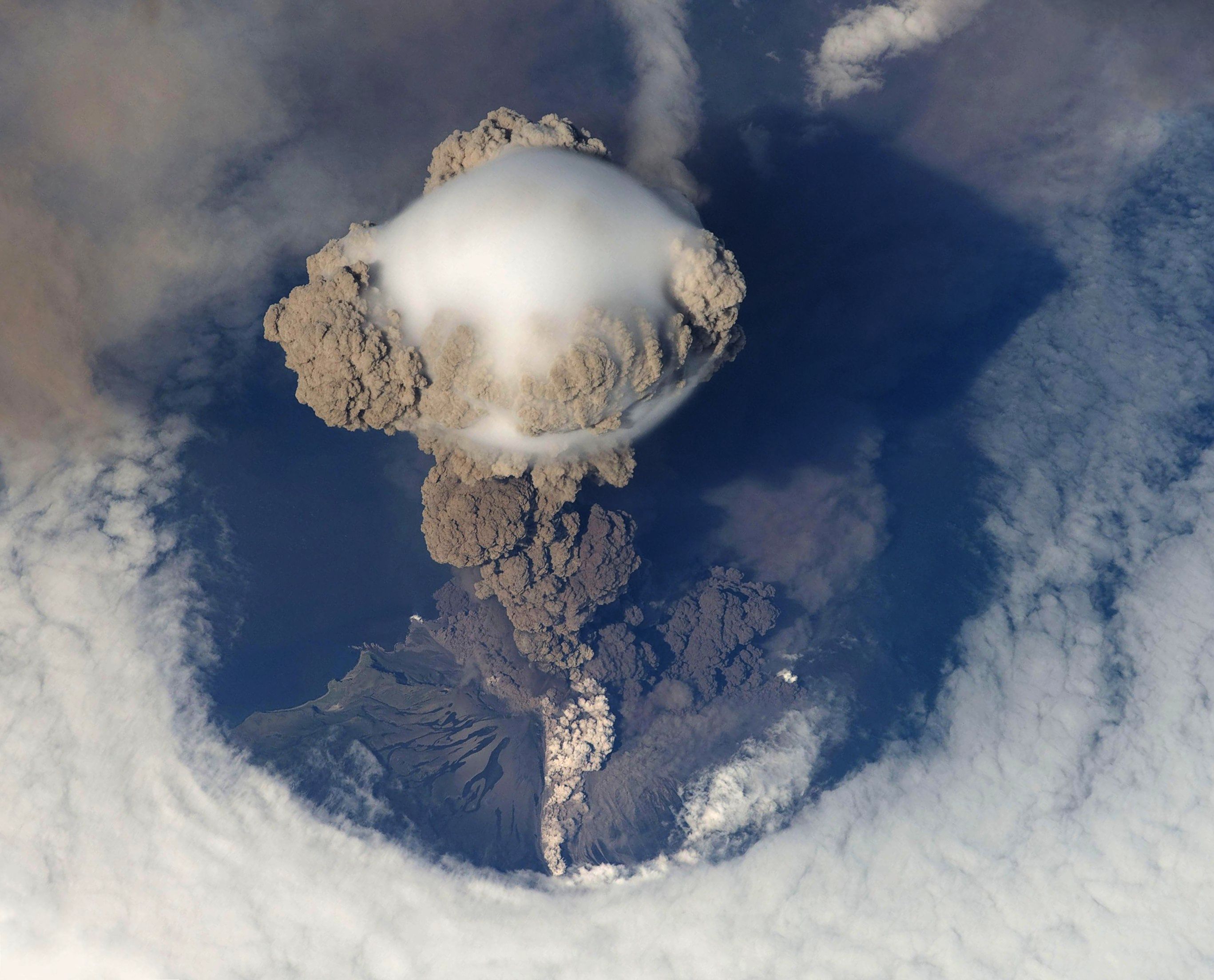
Sarychev Peak (Russian: влк.Сарычева, Japanese: 芙蓉山; Fuyōzan, also known as Matsuwa-Fuji) in the northwest of the island is one of the most active volcanoes of the Kuril Islands. The central cone has a 250-meter (820 ft) wide, very steep-walled crater with a jagged rim, rising to a height of 1,496 metres (4,908 ft). Lava flows descending on all sides of the peak forms capes along the coast. Eruptions have been recorded since the 1760s, including 1878–1879, 1923, 1930, 1946, 1960, 1976, 1981, 1987, 1989 and 2009, with the largest in 1946 which produced pyroclastic flows that reached the sea. The 2009 eruption was large enough to affect air traffic between Asia and North America.
The much smaller peak to the south, Japanese: 天蓋山; Tengaizan has a height of 127 metres (417 ft).

Climate
Although it is located at the same latitude as Paris or Seattle, the Oyashio current on the western flank of the Aleutian Low gives Matua a subarctic climate (Köppen Dfc) that is close to a polar climate (ET). Unlike the quintessential subarctic climate of Siberia or Mongolia, however, Matua has very heavy precipitation as rain, snow and fog. It also has much milder winters than corresponding latitudes in Manchuria: the mean temperature of the coldest month in Matua is −6.1 °C (21.0 °F) as against −17.8 °C (0.0 °F) in Qiqihar in Heilongjiang. Seasonal lag, like in all the Kuril Islands, is a major feature of the climate, with August being the mildest month and February the coldest.
| Climate data for Matua Island (1947-1996) | |||||||||||||
|---|---|---|---|---|---|---|---|---|---|---|---|---|---|
| Month | Jan | Feb | Mar | Apr | May | Jun | Jul | Aug | Sep | Oct | Nov | Dec | Year |
| Record high °C (°F) | 10.4 (50.7) |
8.9 (48.0) |
10.0 (50.0) |
13.8 (56.8) |
23.1 (73.6) |
26.5 (79.7) |
29.0 (84.2) |
27.6 (81.7) |
26.1 (79.0) |
23.9 (75.0) |
12.5 (54.5) |
11.0 (51.8) |
29.0 (84.2) |
| Mean maximum °C (°F) | 2.5 (36.5) |
2.5 (36.5) |
3.7 (38.7) |
8.4 (47.1) |
15.6 (60.1) |
17.7 (63.9) |
21.9 (71.4) |
22.4 (72.3) |
20.0 (68.0) |
13.6 (56.5) |
8.3 (46.9) |
5.3 (41.5) |
24.1 (75.4) |
| Average high °C (°F) | −2.4 (27.7) |
−2.4 (27.7) |
−1.1 (30.0) |
2.0 (35.6) |
6.0 (42.8) |
9.0 (48.2) |
12.4 (54.3) |
14.9 (58.8) |
12.7 (54.9) |
8.8 (47.8) |
3.4 (38.1) |
−0.1 (31.8) |
5.3 (41.5) |
| Daily mean °C (°F) | −4.3 (24.3) |
−4.6 (23.7) |
−3.4 (25.9) |
0.1 (32.2) |
3.3 (37.9) |
5.7 (42.3) |
9.0 (48.2) |
11.1 (52.0) |
9.3 (48.7) |
5.9 (42.6) |
1.1 (34.0) |
−2.3 (27.9) |
2.6 (36.6) |
| Average low °C (°F) | −6.8 (19.8) |
−6.9 (19.6) |
−5.5 (22.1) |
−2.0 (28.4) |
0.2 (32.4) |
2.2 (36.0) |
5.4 (41.7) |
7.4 (45.3) |
6.1 (43.0) |
3.1 (37.6) |
−1.3 (29.7) |
−4.7 (23.5) |
−0.2 (31.6) |
| Mean minimum °C (°F) | −12.8 (9.0) |
−13.6 (7.5) |
−12.2 (10.0) |
−6.5 (20.3) |
−3.2 (26.2) |
−0.8 (30.6) |
1.3 (34.3) |
3.1 (37.6) |
1.5 (34.7) |
−0.8 (30.6) |
−6.0 (21.2) |
−10.3 (13.5) |
−15.1 (4.8) |
| Record low °C (°F) | −20 (−4) |
−18.9 (−2.0) |
−18.9 (−2.0) |
−10 (14) |
−5.1 (22.8) |
−4 (25) |
−3 (27) |
−0.1 (31.8) |
0 (32) |
−6.1 (21.0) |
−11.1 (12.0) |
−17.8 (0.0) |
−20 (−4) |
| Average precipitation mm (inches) | 106.2 (4.18) |
81.5 (3.21) |
84.8 (3.34) |
77.0 (3.03) |
98.8 (3.89) |
76.0 (2.99) |
74.1 (2.92) |
108.7 (4.28) |
139.8 (5.50) |
150.2 (5.91) |
153.1 (6.03) |
122.8 (4.83) |
1,273 (50.11) |
| Average precipitation days (≥ 1 mm) | 22.2 | 19.6 | 16.7 | 12.6 | 11.2 | 8.2 | 7.6 | 9.8 | 12.0 | 16.4 | 21.6 | 22.9 | 180.8 |
| Source 1: Météo climat stats[6] | |||||||||||||
| Source 2: Météo Climat [7] | |||||||||||||
See also
- List of volcanoes in Russia
- Organization of Kita and Minami Fortresses
References
- "Sarychev Peak". Global Volcanism Program. Smithsonian Institution. Retrieved 2021-06-25.
Notes
-
von Krusenstern, Adam Johann (1814). "Officieller Bericht des Hrn. Capit. Ritters v. Krusenstern über des Capitäen's Golownin Reise zur Untersuchung der Kurilischen Inseln." [Official report by Captain Ritter von Kruzenstern on Captain Golovnin's voyage of investigation of the Kuril islands]. In Bertuch, Friedrich Justin (ed.). Allgemeine geographische Ephemeriden (in German). Vol. 43. Weimar: Verlag des Landes-Industrie-Comptoirs. p. 147. Retrieved 2016-06-28.
[...] die Insel Raukoke, auf welcher der Pik Sarytscheff ist, [...] hatte ich [...] auf meiner Charte auch unter den Namen Raukoke aufgenommen. Ihr eigentlicher Name is aber, wie Capitän Golownin berichtet, Matua.
- OSTROV MATUA TALL KING-AIR WARNING RADAR FACILITY, USSR, 1968, Central Intelligence Agency, CIA-RDP78T04759A008300010057-4.
- "Russia's Kuril Islands Naval Base: What It Means Strategically". www.our-russia.com. May 27, 2016.
- "Russian Bastion coastal defense missile systems go on combat alert on Kuril Islands". Tass News. December 4, 2021.
- "International Kuril Island Project(IKIP)". University of Washington Fish Collection or the respective authors. Archived from the original on 2012-10-06. Retrieved 2010-05-29.
- "Moyennes 1981-2010 Russie (Asie)" (in French). Retrieved 1 November 2019.
- "Météo Climat stats for Kurilsk". Météo Climat. Retrieved 1 November 2019.
Further reading
- Gorshkov, G. S. Volcanism and the Upper Mantle Investigations in the Kurile Island Arc. Monographs in geoscience. New York: Plenum Press, 1970. ISBN 0-306-30407-4
- Krasheninnikov, Stepan Petrovich, and James Greive. The History of Kamtschatka and the Kurilski Islands, with the Countries Adjacent. Chicago: Quadrangle Books, 1963.
- Rees, David. The Soviet Seizure of the Kuriles. New York: Praeger, 1985. ISBN 0-03-002552-4
- Takahashi, Hideki, and Masahiro Ōhara. Biodiversity and Biogeography of the Kuril Islands and Sakhalin. Bulletin of the Hokkaido University Museum, no. 2-. Sapporo, Japan: Hokkaido University Museum, 2004.
External links
![]() Media related to Matua Island at Wikimedia Commons
Media related to Matua Island at Wikimedia Commons
- Matua Island at Oceandots at the Wayback Machine (archived December 23, 2010)
| Authority control |
|
|---|
На других языках
[de] Matua
Matua (russisch Матуа; jap. 松輪島, Matsua-tō[1]) ist eine zu Russland gehörende Insel der zentralen Kurilengruppe. Ihre Fläche beträgt 52 km². 30 km südwestlich liegt Rasschua (羅処和島, Rasutsua-tō[1]), 18 km nordöstlich die kleine Insel Raikoke (雷公計島, Raikoke-tō[1]).- [en] Matua (island)
[es] Matua
Matua (en ruso: Матуа) es una isla rusa en el archipiélago de las Kuriles. Tiene una superficie de 52 km², que se vio ampliada otro kilómetro y medio por los flujos de lava que se produjeron tras una erupción en 2009.[1] Pertenece al grupo de las Kuriles centrales. Administrativamente, forma parte del óblast de Sajalín.[fr] Matoua
Matoua (en russe Матуа Mátua, en japonais 松輪島 Matsuwa-tô) est une île volcanique inhabitée de l’archipel des îles Kouriles, appartenant à la Russie.[it] Isola di Matua
Matua (in russo Матуа; in giapponese 松輪島, Matsuwa-tō) è un'isola russa che fa parte dell'arcipelago delle Isole Curili ed è situata tra il Mare di Ochotsk e l'Oceano Pacifico settentrionale. Amministrativamente fa parte del Severo-Kuril'skij rajon dell'oblast' di Sachalin, nel Circondario federale dell'Estremo Oriente. L'isola è disabitata.[ru] Матуа
Ма́туа (яп. 松輪島, Мацуа; на русской карте 1745-го года — Уригикай[1][2]) — остров средней группы Большой гряды Курильских островов. Административно входит в Северо-Курильский городской округ Сахалинской области (с 1946 года). Имел стратегически важную роль в годы Второй мировой войны, будучи одной из крупнейших японских военно-морских баз. Коренными жителями острова были охотники и собиратели айны, но после 1875 года их сменили японские военные, которых в 1945 году сменили советские военные.Другой контент может иметь иную лицензию. Перед использованием материалов сайта WikiSort.org внимательно изучите правила лицензирования конкретных элементов наполнения сайта.
WikiSort.org - проект по пересортировке и дополнению контента Википедии