geo.wikisort.org - Island
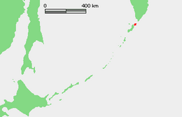
Shumshu (Russian: Шумшу, romanized: Shumshu; Japanese: 占守島, romanized: Shumushu-tō; Ainu: スㇺス (reconstruction), lit. 'good island') is the second-northernmost island of the Kuril Islands chain, which divides the Sea of Okhotsk from the northwest Pacific Ocean. The name of the island is derived from the Ainu language, meaning "good island". It is separated from Paramushir by the very narrow Second Kuril Strait in the northeast 2.5 kilometres (1.6 mi), and its northern tip is 11 kilometres (6.8 mi), from Cape Lopatka at the southern tip of the Kamchatka Peninsula. The island has a seasonal population of around 100 inhabitants.
This article includes a list of general references, but it lacks sufficient corresponding inline citations. (March 2012) |
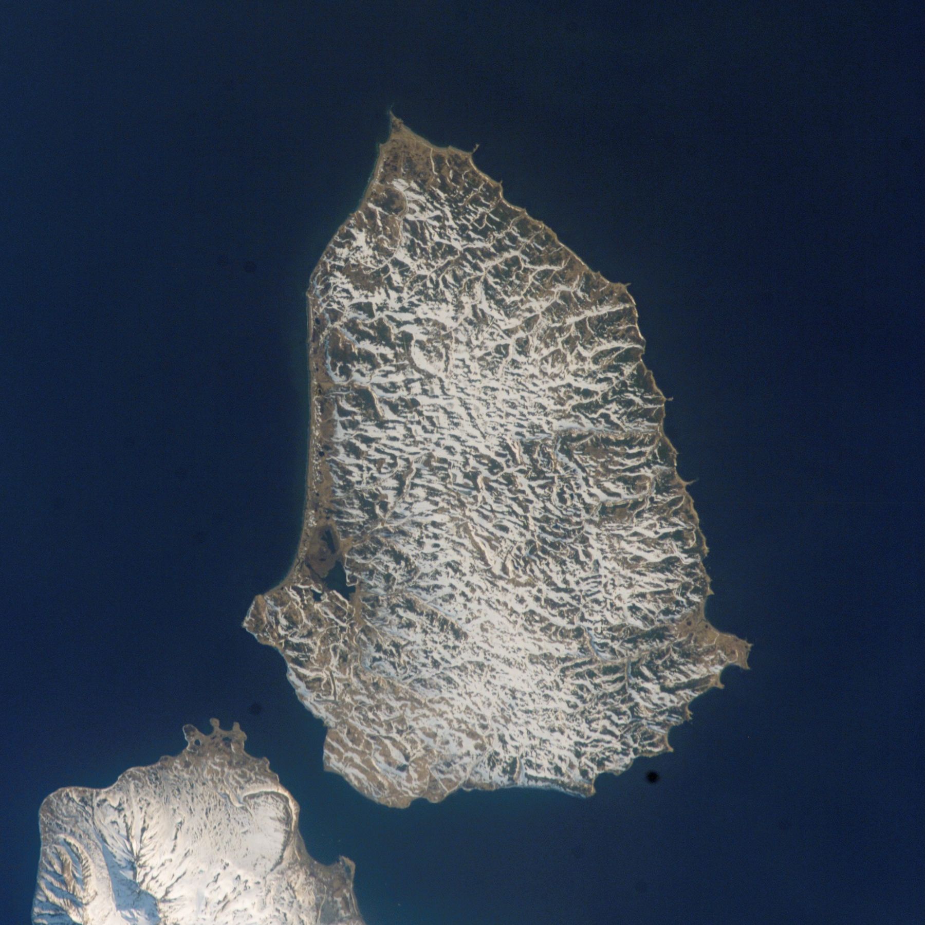 A Landsat 7 image of Shumshu Island. The northern tip of Paramushir Island is at left. The First Kuril Strait lies across the upper portion of the image. | |
 | |
| Geography | |
| Location | Pacific Ocean |
| Coordinates | 50°44′N 156°19′E |
| Archipelago | Kuril Island |
| Area | 388 km2 (150 sq mi) |
| Length | 28 km (17.4 mi) |
| Width | 15 km (9.3 mi) |
| Highest elevation | 171 m (561 ft) |
| Administration | |
Russia | |
| Oblast | Sakhalin Oblast |
| District | Severo-Kurilsky |
| Demographics | |
| Population | ± 100 (seasonal) |
Geography
Shumshu is the least elevated in the entire Kuril group with a height of 189 metres (620 feet). The terrain is low-lying and covered with numerous lakes and marshland. Shumshu is roughly oval, and has an area of 388 square kilometres (150 square miles).[1]
Main Features
- Ozero Utinoye (lake)
- Ozero Dogovoye (lake)
- Ozero Kuzminovskoye (lake)
- Ozero Bol'shoye (lake)
- Bukhta Shumnaya (bay)
- Bukhta Sakulina (bay)
- Bukhta Inozemtseva (bay)
- Bukhta Mayachnaya (bay)
- Nakagawa-wan (bay)
- Katoka-wan (bay)
History
Shumshu was inhabited by the Ainu, who subsisted off of the abundant fish, marine mammals and birdlife in the area, at the time of European contact. The island appears on an official map showing the territories of Matsumae Domain, a feudal domain of Edo-period Japan dated 1644. Due to its proximity to the Kamchatka Peninsula, Shumshu became the first of the Kurils to be reached by Cossacks from the peninsula in the first years of the 18th century. Russian fur traders are known to have visited the island in 1711 and 1713, and it was from this base that Russian fur hunters and traders gradually expanded into other islands of the chain and Sakhalin. Although the Tokugawa shogunate of Japan officially confirmed the Matsumae Domain’s claims to the island, the island remained outside of de facto Japanese control. Also claimed by the Empire of Russia, sovereignty over the island was confirmed to be under Russia under the terms of the Treaty of Shimoda in 1855. In 1875, sovereignty over the Kuril Islands, including Shumshu, was transferred to the Empire of Japan per the Treaty of Saint Petersburg. A number of Japanese colonizing expeditions followed, establishing the settlement of Kataoka (on the site of the Ainu settlement of Mairuppo) as the commercial center of Shumshu. As the island closest to Russia, it became an important Japanese military outpost, as well as a center for the commercial fishing industry. The island was administered as part of the Shumushu District of Nemuro Subprefecture of Hokkaidō. In 1910, a cannery was established, and the island’s civilian population exceeded 2,000 by the early 1940s.
Towards the end of World War II the island was strongly garrisoned by both the Imperial Japanese Army (IJA) and Imperial Japanese Navy (IJN). A garrison of over 24,500 men reinforced by sixty tanks was garrisoned on Shumshu in nine locations centered around Kataoka. All coastal areas suitable for enemy amphibious landings were covered with permanent emplacements and bunkers, interconnected with underground passages and trenches. All the warehouses, power stations, and hospitals were up to 50 metres (164 ft) underground. These defenses were manned by the IJA 91st Division, with the IJA 73rd Infantry Brigade. Miyoshino Airfield was a joint IJA-IJN airfield, located near the center of the island, and it hosted several aviation units operating various aircraft including IJN Nakajima B5N2 (Allied reporting name "Kate") and Mitsubishi G3M (Allied reporting name "Nell") and IJA Nakajima Ki-44 (Allied reporting name "Tojo") and Nakajima Ki-43 (Allied reporting name "Oscar") aircraft. Kataoka Naval Base was under the command of the IJN′s 5th Fleet and had three 60-foot (18.3 m) oil storage tanks as well as barracks and supply buildings. The base also had a seaplane facility in the harbor, and neighboring Imaizaki Airfield had a 4,000-foot (1,200 m) and a 5,000-foot (1,500 m) runway. These facilities were subject to sporadic air raids by United States Army Air Forces and United States Navy forces based in the Aleutian Islands from 1943 until the Japanese Emperor Hirohito announced the surrender of Japan on 15 August 1945.
The Soviet Union continued combat operations against Japan until early September 1945. During the Invasion of the Kuril Islands, Soviet forces landed on Shumshu on 18 August 1945, beginning the Battle of Shumshu, one of the last battles of World War II. Combat operations continued through 23 August 1945, ending with the surrender of the surviving members of the Japanese garrison. The Soviets sent the Japanese prisoners of war, including most Japanese male civilians, to labor camps and forcibly deported the remaining Japanese civilian inhabitants. The Soviets renamed Kataoka Baikovo (Russian: Байково), and the Soviet Union annexed the island in 1946, including it in the Russian Soviet Federated Socialist Republic. Japan formally gave up sovereignty over the island under the terms of the San Francisco Peace Treaty of 1951.
The island remained a part of Russia after the 1991 dissolution of the Soviet Union and is now administered as part of the Sakhalin Oblast of the Russian Federation.
See also
Notes
- "International Kuril Island Project(IKIP)". University of Washington Fish Collection or the respective authors.
References
- Gorshkov, G. S. Volcanism and the Upper Mantle Investigations in the Kurile Island Arc. Monographs in geoscience. New York: Plenum Press, 1970. ISBN 0-306-30407-4
- Krasheninnikov, Stepan Petrovich, and James Greive. The History of Kamtschatka and the Kurilski Islands, with the Countries Adjacent. Chicago: Quadrangle Books, 1963.
- Rees, David. The Soviet Seizure of the Kuriles. New York: Praeger, 1985. ISBN 0-03-002552-4
- Takahashi, Hideki, and Masahiro Ōhara. Biodiversity and Biogeography of the Kuril Islands and Sakhalin. Bulletin of the Hokkaido University Museum, no. 2-. Sapporo, Japan: Hokkaido University Museum, 2004.
External links
| Wikimedia Commons has media related to Shumshu. |
- Shumshu Island — Oceandots. at the Wayback Machine (archived December 23, 2010)
- Pictures
- Abandoned tanks of Shumshu island
|
Authority control | |
|---|---|
| General | |
| National libraries | |
На других языках
[de] Schumschu
Schumschu (russisch Шумшу; jap. .mw-parser-output .Hani{font-size:110%}占守島, Shumushu-tō) ist die nordöstlichste Insel der Kurilen. Administrativ gehört sie zur russischen Oblast Sachalin.- [en] Shumshu
[es] Shumshu
Shumshu (en ruso, Шумшу, y en japonés, Shumushu) es una isla rusa en el archipiélago de las Kuriles. Tiene una superficie de 388 km². Pertenece al grupo de las Kuriles septentrionales.[fr] Choumchou
Choumchou (en russe : Шумшу, en japonais : 占守島) est l’île la plus au nord de l'archipel des îles Kouriles. Elle est séparée de la péninsule du Kamtchatka et notamment du cap Lopatka par un bras de mer d'une dizaine de kilomètres de largeur, le premier détroit des Kouriles.[it] Šumšu
Šumšu (in russo Шумшу; in giapponese 占守島, Shumushu-tō) è un'isola russa che fa parte dell'arcipelago delle Isole Curili, situata tra il Mare di Ochotsk e l'Oceano Pacifico settentrionale. Amministrativamente fa parte del Severo-Kuril'skij rajon dell'oblast' di Sachalin, nel Circondario federale dell'Estremo Oriente. Il suo nome in lingua ainu significa "buona isola".[ru] Шумшу
Шумшу́ (яп. 占守島, Сюмусю-то; на российской карте 1745-го года — Шумъ[1]) — один из островов северной группы Курильских островов. Отделён от Камчатки (мыс Лопатка) Первым Курильским проливом шириной около 11 км, от острова Парамушир — Вторым Курильским проливом, шириной около 2 км. Административно остров входит в Северо-Курильский городской округ Сахалинской области.Другой контент может иметь иную лицензию. Перед использованием материалов сайта WikiSort.org внимательно изучите правила лицензирования конкретных элементов наполнения сайта.
WikiSort.org - проект по пересортировке и дополнению контента Википедии