geo.wikisort.org - Sea
Odyan Bay (Russian: Залив Одян, trans.: Zaliv Odyan) is a small bay on the north coast of the Sea of Okhotsk. It is in the eastern corner of Taui Bay. The bay is entered between Cape Beringa to the northeast and Cape Skalisty to the southwest. It is 19.3 km (about 12 mi) wide. The high entrance points of the bay merge to form a low, sandy shore at its head. Ice remains in the bay longer than in other parts of Taui Bay. It is sheltered from all but west winds. Umara Island lies just off its south shore.[1]
| Odyan Bay | |
|---|---|
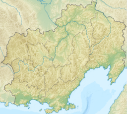 Odyan Bay Location in Magadan Oblast | |
| Location | Subarctic |
| Coordinates | 59°12′N 152°01′E |
| Ocean/sea sources | Sea of Okhotsk |
| Basin countries | Russia |
| Max. width | 19.3 km (12.0 mi) |
References
- National Geospatial-Intelligence Agency. (2014). Sailing Directions (Enroute): East Coast of Russia. U.S. Government, Springfield, Virginia.
This Magadan Oblast location article is a stub. You can help Wikipedia by expanding it. |
На других языках
- [en] Odyan Bay
[ru] Одян
Одя́н[1] — залив в восточной части Тауйской губы Охотского моря. Находится под юрисдикцией Ольского района Магаданской области.Текст в блоке "Читать" взят с сайта "Википедия" и доступен по лицензии Creative Commons Attribution-ShareAlike; в отдельных случаях могут действовать дополнительные условия.
Другой контент может иметь иную лицензию. Перед использованием материалов сайта WikiSort.org внимательно изучите правила лицензирования конкретных элементов наполнения сайта.
Другой контент может иметь иную лицензию. Перед использованием материалов сайта WikiSort.org внимательно изучите правила лицензирования конкретных элементов наполнения сайта.
2019-2026
WikiSort.org - проект по пересортировке и дополнению контента Википедии
WikiSort.org - проект по пересортировке и дополнению контента Википедии