 Some of the spectacular views around Qikiqtarjuaq (12 July 2011)
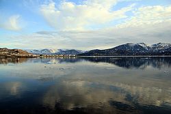 Summer in the Arctic at Broughton Island (12 July 2011)
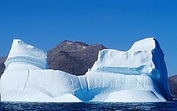 Iceberg near Qikiqtarjuaq (Davis Strait, 12 August 2000)
geo.wikisort.org - Island
Broughton Island is a 127.6 km2 (49.3 sq mi)[3] island in the Arctic Archipelago.
 Qikiqtarjuaq, 24 July 2001 | |
 Broughton Island  Broughton Island | |
| Geography | |
|---|---|
| Location | Coast of the Cumberland Peninsula, Baffin Island |
| Coordinates | 67°34′N 063°54′W[1] |
| Archipelago | Arctic Archipelago |
| Area | 127.6[3] km2 (49.3 sq mi) |
| Administration | |
Canada | |
| Territory | Nunavut |
| Region | Qikiqtaaluk |
| Largest settlement | Qikiqtarjuaq (pop. 593) |
| Demographics | |
| Population | 593 (2021[4]) |
| Ethnic groups | Inuit |
Geography
It is located above the Arctic Circle in the Davis Strait, off Baffin Island about 2 km (1.2 mi) west of the Cumberland Peninsula. To the east Baffin Bay, and the Baffin Mountains are located to the west, more specifically the Arctic Cordillera mountain range.
Demographics
The only community on the island is Qikiqtarjuaq with a population of 593.[4] It is one of only eleven islands, out of more than 36,000, in the Arctic Archipelago that are inhabited. The Inuit residents of Qikiqtarjuaq moved there in 1963 from a whaling station at Kivitoo about 50 km (31 mi) north.
Qikiqtarjuaq hosts an annual "Suicide Prevention Walk".[5] Local participants would walk a total distance of 60 km (37 mi) across the tundra from Kivitoo'[6] Today the walk is much shorter than the original two and a half days, but it is still meant to promote hope among the community.
The island was the home of FOX-5, a Distant Early Warning Line and now a North Warning System site.
There is also an access road that was built to Tisunaaq, also known as Ceetee Land to the Elders, and another road is in construction to Qikiqtarjuaqruluk, or Old Broughton, an abandoned settlement.
Wildlife
The island is known for Arctic wildlife including ring seals, polar bears, bowhead whales, narwhals, and bird watching. The Qaqulluit National Wildlife Area is located about 55 km (34 mi) south east at 67°14′N 62°28′W.[7] It serves as the northern access point for Auyuittuq National Park (see also Pangnirtung) and is approximately 2 hours by boat in the summer months, 2 - 2.5 hours by vehicle or snowmobile in winter months. All park visitors must register and book an orientation session prior to entry into the park, and non-Inuit who visit Auyuittuq must do so by hiring a local licensed operator.
Gallery
Broughton Island and Qikiqtarjuaq


Climate
Broughton Island has a tundra climate (ET), with the warmest month averaging below 6 °C (43 °F). Summers tend to be cool with chilly nights, while winters are long and cold. Early winter is the snowiest time of the year, with more than half of all year snowfall on average falling during this period.
| Climate data for Qikiqtarjuaq (FOX-5) WMO ID: 71096; coordinates 67°32′08″N 63°47′20″W; elevation: 584.4 m (1,917 ft); 1981–2010 normals | |||||||||||||
|---|---|---|---|---|---|---|---|---|---|---|---|---|---|
| Month | Jan | Feb | Mar | Apr | May | Jun | Jul | Aug | Sep | Oct | Nov | Dec | Year |
| Record high humidex | 1.5 | 0.0 | 2.7 | 6.1 | 8.6 | 18.6 | 20.7 | 19.9 | 13.6 | 7.0 | 3.5 | 3.9 | 20.7 |
| Record high °C (°F) | 3.9 (39.0) |
1.1 (34.0) |
4.0 (39.2) |
7.8 (46.0) |
14.2 (57.6) |
17.8 (64.0) |
20.7 (69.3) |
22.6 (72.7) |
14.4 (57.9) |
10.6 (51.1) |
7.5 (45.5) |
5.0 (41.0) |
22.6 (72.7) |
| Average high °C (°F) | −22.8 (−9.0) |
−22.4 (−8.3) |
−19.6 (−3.3) |
−13.6 (7.5) |
−5.4 (22.3) |
2.8 (37.0) |
8.2 (46.8) |
6.3 (43.3) |
−0.1 (31.8) |
−4.9 (23.2) |
−11.9 (10.6) |
−18.5 (−1.3) |
−8.5 (16.7) |
| Daily mean °C (°F) | −25.4 (−13.7) |
−25.2 (−13.4) |
−22.9 (−9.2) |
−16.9 (1.6) |
−8.2 (17.2) |
0.2 (32.4) |
5.3 (41.5) |
3.7 (38.7) |
−1.9 (28.6) |
−6.9 (19.6) |
−14.2 (6.4) |
−21.1 (−6.0) |
−11.1 (12.0) |
| Average low °C (°F) | −28.0 (−18.4) |
−28.0 (−18.4) |
−26.1 (−15.0) |
−20.2 (−4.4) |
−10.9 (12.4) |
−2.4 (27.7) |
2.4 (36.3) |
1.1 (34.0) |
−3.8 (25.2) |
−9.0 (15.8) |
−16.6 (2.1) |
−23.7 (−10.7) |
−13.8 (7.2) |
| Record low °C (°F) | −41.7 (−43.1) |
−42.8 (−45.0) |
−40.7 (−41.3) |
−34.3 (−29.7) |
−26.1 (−15.0) |
−12.2 (10.0) |
−8.9 (16.0) |
−7.8 (18.0) |
−13.9 (7.0) |
−24.4 (−11.9) |
−33.3 (−27.9) |
−39.2 (−38.6) |
−42.8 (−45.0) |
| Record low wind chill | −61.1 | −61.0 | −57.1 | −49.2 | −35.8 | −21.1 | −18.6 | −15.5 | −23.9 | −32.8 | −45.2 | −54.2 | −61.1 |
| Average precipitation mm (inches) | 3.7 (0.15) |
6.1 (0.24) |
3.6 (0.14) |
12.7 (0.50) |
23.7 (0.93) |
10.2 (0.40) |
18.1 (0.71) |
24.2 (0.95) |
30.0 (1.18) |
36.7 (1.44) |
29.7 (1.17) |
4.7 (0.19) |
203.3 (8.00) |
| Average rainfall mm (inches) | 0.0 (0.0) |
0.0 (0.0) |
0.0 (0.0) |
0.0 (0.0) |
0.0 (0.0) |
0.8 (0.03) |
10.8 (0.43) |
15.7 (0.62) |
2.4 (0.09) |
0.3 (0.01) |
0.0 (0.0) |
0.0 (0.0) |
30.0 (1.18) |
| Average snowfall cm (inches) | 3.7 (1.5) |
6.1 (2.4) |
3.6 (1.4) |
12.7 (5.0) |
23.7 (9.3) |
9.4 (3.7) |
7.3 (2.9) |
8.5 (3.3) |
27.7 (10.9) |
36.3 (14.3) |
29.7 (11.7) |
4.7 (1.9) |
173.3 (68.2) |
| Average precipitation days (≥ 0.2 mm) | 2.9 | 2.8 | 2.5 | 5.0 | 8.2 | 3.9 | 6.3 | 8.2 | 8.3 | 12.8 | 7.4 | 4.1 | 72.3 |
| Average rainy days (≥ 0.2 mm) | 0.0 | 0.0 | 0.0 | 0.0 | 0.0 | 0.5 | 4.8 | 5.2 | 0.6 | 0.2 | 0.0 | 0.0 | 11.2 |
| Average snowy days (≥ 0.2 cm) | 2.9 | 2.8 | 2.5 | 5.0 | 8.2 | 3.3 | 1.7 | 3.1 | 7.7 | 12.7 | 7.4 | 4.1 | 61.3 |
| Average relative humidity (%) | 76.6 | 74.7 | 76.6 | 81.5 | 88.0 | 85.5 | 78.4 | 81.5 | 91.2 | 88.7 | 83.7 | 79.2 | 82.1 |
| Source: Environment and Climate Change Canada Canadian Climate Normals 1981–2010[8] | |||||||||||||
References
- "Broughton Island". Geographical Names Data Base. Natural Resources Canada.
- "Broughton Island". Geographical Names Data Base. Natural Resources Canada.
- "Islands By Land Area". Islands.unep.ch. Retrieved 27 May 2022.
- "Population and dwelling counts: Canada, provinces and territories, and census subdivisions (municipalities), Nunavut". Statistics Canada. 9 February 2022. Retrieved 19 February 2022.
- "Suicide prevention in Nunavut: Qikiqtarjuaq walkers show they care". www.nunatsiaqonline.ca. Retrieved 13 February 2017.
- "NTI CA IIBA Phase 1 Draft – Cultural Heritage Resources Report – Akpait & Qaqulluit Project" (PDF). p. 12.
- "Qaqulluit National Wildlife Area". 24 December 2022. Retrieved 27 May 2022.
- "Fox Five" (CSV (4222 KB)). Canadian Climate Normals 1981–2010. Environment and Climate Change Canada. Climate ID: 2400570. Retrieved 27 November 2013.[permanent dead link]
Текст в блоке "Читать" взят с сайта "Википедия" и доступен по лицензии Creative Commons Attribution-ShareAlike; в отдельных случаях могут действовать дополнительные условия.
Другой контент может иметь иную лицензию. Перед использованием материалов сайта WikiSort.org внимательно изучите правила лицензирования конкретных элементов наполнения сайта.
Другой контент может иметь иную лицензию. Перед использованием материалов сайта WikiSort.org внимательно изучите правила лицензирования конкретных элементов наполнения сайта.
2019-2025
WikiSort.org - проект по пересортировке и дополнению контента Википедии
WikiSort.org - проект по пересортировке и дополнению контента Википедии