geo.wikisort.org - Island
Beechey Island (Inuktitut: Iluvialuit) is an island located in the Arctic Archipelago of Nunavut, Canada, in Wellington Channel. It is separated from the southwest corner of Devon Island by Barrow Strait. Other features include Wellington Channel, Erebus Harbour,[3] and Terror Bay (not to be confused with the Terror Bay south of King William Island).
Native name: Iluvialuit | |
|---|---|
 Beechey Island Location in the Arctic Archipelago  Beechey Island Beechey Island (Canada) | |
| Geography | |
| Location | Northern Canada |
| Coordinates | 74°43′N 091°51′W[1] |
| Archipelago | Queen Elizabeth Islands Arctic Archipelago |
| Area | 4.6 km2 (1.8 sq mi) |
| Highest elevation | 198 m (650 ft) |
| Highest point | Un-named |
| Administration | |
Canada | |
| Territory | Nunavut |
| Demographics | |
| Population | Uninhabited |
National Historic Site of Canada | |
| Official name | Beechey Island Sites National Historic Sites of Canada |
| Designated | 1993 |
History
The first European visit to the island was in 1819, by Captain William Edward Parry. The island was named after the artist William Beechey (1753–1839) by his son Frederick William Beechey (1796–1856), who was then serving as Parry's lieutenant.[4]

It is the site of several very significant events in the history of Arctic exploration. In 1845, the British explorer Sir John Franklin, commanding a new but ill-fated search for the Northwest Passage aboard HMS Erebus and HMS Terror, chose the protected harbour of Beechey Island for his first winter encampment. The site was not rediscovered until 1851, when British and United States search vessels anchored nearby.
In 1850, Edward Belcher used the island as a base. There are memorials to Franklin and other polar explorers and sailors on the island, including the French naval officer Joseph René Bellot, who died aged 27 falling into the Wellington Channel, northwest of Beechey Island.[5]
In 1903, paying respect to Franklin, Norwegian explorer Roald Amundsen stopped at the island at the beginning of his successful voyage through the Northwest Passage.
In 1975, Beechey Island was declared a Territorial Historic Site by the government of the Northwest Territories. Since 1999, it has been part of the newly created Canadian territory of Nunavut.[6]
In 1993, five archaeological sites on Beechey Island and nearby Devon Island (the Franklin wintering camp of 1845–46, Northumberland House, the Devon Island site at Cape Riley, two message cairns, and the HMS Breadalbane National Historic Site) were designated as the Beechey Island Sites National Historic Site of Canada.[7]
Beechey Island graves
Beechey Island is best known for containing three graves of Franklin expedition members, which were first discovered in 1850 by searchers for the lost Franklin expedition. The searchers found a large stone cairn, along with the graves of three of Franklin's crewmen – Petty Officer John Torrington, Royal Marine Private William Braine, and Able Seaman John Hartnell – but no written record nor indication of where Franklin planned to sail the next season.
In 1852, Commander Edward A. Inglefield arrived at Beechey, along with a physician Dr Peter Sutherland. John Hartnell's grave was opened, damaging his coffin, and Hartnell's memorial plaque on the coffin lid was removed. During a later expedition, a searcher named Thomas Morgan died aboard the vessel North Star on May 22, 1854, and was buried alongside the three original Franklin crew members.
In the 1980s, during two separate expeditions to Beechey, Canadian forensic anthropologist Dr. Owen Beattie examined the three bodies and found them (externally) remarkably well-preserved. Autopsies determined that lung disease and lead poisoning were among the probable causes of death; the lead appeared to come from the thousands of lead-soldered tins of provisions with which the Franklin expedition had been supplied (although later studies would suggest that the unique water distillation system used by the ships was the major source of lead poisoning).[8]
Later research, however, found through hair sample comparisons between the Beechey remains and those of expedition assistant surgeon and naturalist Harry Goodsir (who died on the expedition a year later, and would therefore be expected to have yet further exposure, under the lead poisoning hypothesis) that the lead in the three men's remains, while indeed present at high levels now recognized as deleterious, was no higher than Goodsir's, and thus evidently mostly the result of exposure prior to the expedition (due to high everyday lead exposure common in the 19th century), and consequently was unlikely to be solely responsible for their deaths.[9][10]
In the 1990s, due to the deteriorating condition of the Beechey grave markers, all markers were replaced with bronze memorials.
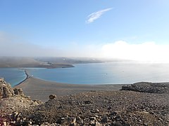 Beechey Island Harbour viewed from northwest summit of Beechey Island, Nunavut, Canada.
 (L-R) Three graves from the lost 1845 Franklin Expedition, and a fourth from a later Franklin search expedition.
 (L-R) The Franklin Camp graves of John Torrington, William Braine, John Hartnell and Thomas Morgan.
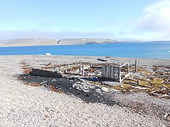 Remains of Northumberland House on the shore of Beechey Island.


In fiction
The explorers in Jules Verne's novel The Adventures of Captain Hatteras (French: Voyages et aventures du capitaine Hatteras) visit Beechey Island. In addition, Clive Cussler's novel, Arctic Drift (2008), featured characters who would visit this island in the quest for Franklin's ships. The island is also mentioned in Dan Simmons' novel, The Terror.
References
- "Beechey Island". Geographical Names Data Base. Natural Resources Canada.
- "Beechey Island". Geographical Names Data Base. Natural Resources Canada.
- "Beechy Island". Google.com. Retrieved 2015-06-23.
- Parry, W.E. (1821). Journal of a Voyage for the Discovery of a North-west Passage from the Atlantic to the Pacific: Performed in the Years 1819-20, in His Majesty's Ships Hecla and Griper, Under the Orders of William Edward Parry ; with an Appendix, Containing the Scientific and Other Observations. Vol. 1. John Murray. p. 51. Retrieved 2015-06-23.
- Brian D. Powell (2006). "The memorials on Beechey Island, Nunavut, Canada: an historical and pictorial survey". Polar Record. 42 (223): 325–333. doi:10.1017/S0032247406005596.
- Beechey Island. Canadian Register of Historic Places. Retrieved 29 October 2013.
- Beechey Island Sites National Historic Site of Canada. Canadian Register of Historic Places. Retrieved 29 October 2013.
- Preserved remains: discovery of the bodies
- D'Ortenzio, Lori; Inskip, Michael; Manton, William; Mays, Simon (October 2018). "The Franklin expedition: What sequential analysis of hair reveals about lead exposure prior to death". Journal of Archaeological Science: Reports. 21: 401–405. doi:10.1016/j.jasrep.2018.08.021.
- Smith, Kiona N. (2018-09-30). "Strands of hair shed light on doomed 19th-century Arctic expedition". Ars Technica.
External links
- Beechey Island in the Atlas of Canada - Toporama; Natural Resources Canada
National Historic Sites of Canada by location | |
|---|---|
| Provinces |
|
| Territories |
|
| Other countries |
|
| |
На других языках
[de] Beechey Island
Beechey Island ist eine Insel 75 Kilometer östlich der Resolute Bay und ist ein relativ kleines, Devon Island unmittelbar südwestlich vorgelagertes und mit ihr verbundenes Felsgebirge in der kanadischen Arktis. Sie erhielt besondere historische Bedeutung, nachdem Captain Erasmus Ommanney am 23. August 1850 das nahe gelegene Cape Riley erreichte und kurz danach auf Beechey Reste eines Winterlagers und Gräber entdeckte, die sich als die ersten Spuren der seit 1845 vermissten Franklin-Expedition erwiesen. 1979 wurden sechs mit der Expedition in Verbindung stehende Orte auf die Insel bzw. im Meer vor der Insel von der kanadischen Regierung als „Beechey Island Sites National Historic Site of Canada“ zur National Historic Site of Canada erklärt.[1]- [en] Beechey Island
[es] Isla Beechey
La isla de Beechey (en inglés, Beechey Island) es una pequeña isla situada en el archipiélago ártico canadiense, muy cerca de la costa occidental de isla Devon. Administrativamente pertenece al territorio autónomo de Nunavut, Canadá.[fr] Île Beechey
L'île Beechey est une île de l'archipel arctique canadien, du Nunavut, au Canada. Elle a une superficie d'environ 460 ha.[it] Isola di Beechey
L'isola di Beechey (in inglese Beechey Island) è un'isola dell'Arcipelago artico canadese, facente parte del territorio di Nunavut e ubicata nel Canale di Wellington.[ru] Бичи (остров)
Би́чи (англ. Beechey Island; инук. Piiti Ailant) — остров, расположенный в Канадском Арктическом архипелаге на территории Нунавут, Канада. Он отделён от Юго-Западного угла острова Девон проливом Барроу[1]. Среди других особенностей острова можно отметить канал Веллингтон, гавань Эребус[2] и залив Террор.Другой контент может иметь иную лицензию. Перед использованием материалов сайта WikiSort.org внимательно изучите правила лицензирования конкретных элементов наполнения сайта.
WikiSort.org - проект по пересортировке и дополнению контента Википедии