geo.wikisort.org - Island
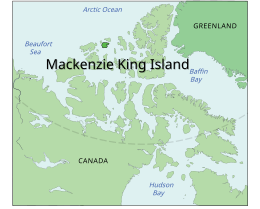
Mackenzie King Island is one of the Queen Elizabeth Islands in northern Canada. It lies north of Melville Island and south of Borden Island, and like them is divided when it comes to administration. Most of the island is in Northwest Territories, while its easternmost portion lies in Nunavut. The border runs along the 110th meridian west.
 Mackenzie King Island with Brock and Borden Island | |
 | |
 Mackenzie King Island  Mackenzie King Island  Mackenzie King Island | |
| Geography | |
|---|---|
| Location | Northern Canada |
| Coordinates | 77°45′N 112°00′W |
| Archipelago | Queen Elizabeth Islands Arctic Archipelago |
| Area | 5,048 km2 (1,949 sq mi) |
| Length | 61 mi (98 km) |
| Width | 60 mi (100 km) |
| Highest elevation | 112 m (367 ft) |
| Administration | |
Canada | |
| Territory | Northwest Territories Nunavut |
| Demographics | |
| Population | 0 |
Mackenzie King has an area of 5,048 km2 (1,949 sq mi), 60 miles (97 km) long in northeast or 47 miles (76 km) in southeast and 60 miles (97 km) wide, making it the 116th largest island in the world, and Canada's 26th largest island.
History
The first known visit to the island was by Vilhjalmur Stefansson in 1915, and it was later named for William Lyon Mackenzie King.[1]
References
- "King, The Right Hon. William Lyon Mackenzie". parl.gc.ca. Retrieved 2008-05-18.
Further reading
- Vilks, G. Foraminiferal Study of East Bay, Mackenzie King Island, District of Franklin (Polar Continental Shelf Project). [Ottawa]: Dept. of Mines and Technical Surveys, 1964.

External links
This Canadian Northwest Territories location article is a stub. You can help Wikipedia by expanding it. |
This Qikiqtaaluk Region, Nunavut location article is a stub. You can help Wikipedia by expanding it. |
На других языках
[de] Mackenzie King Island
Mackenzie King Island liegt im Westen des Kanadisch-Arktischen Archipels und gehört zu den Königin-Elisabeth-Inseln. Der größte, westliche Teil gehört zu den Nordwest-Territorien, nur ein kleiner, östlicher Teil gehört zum kanadischen Territorium Nunavut.- [en] Mackenzie King Island
[es] Isla Mackenzie King
La isla Mackenzie King es una isla deshabitada del Archipiélago ártico canadiense. Administrativamente, la isla está dividida en dos: la parte occidental, casi la totalidad de la isla, pertenece a los Territorios del Noroeste y una muy pequeña parte. el borde oriental, al territorio autónomo de Nunavut.[fr] Île Mackenzie King
L'île Mackenzie King fait partie de l'archipel arctique canadien dans les îles de la Reine-Elisabeth dans le Nord du Canada. Elle est située au nord de l'île Melville et au sud de l'île Borden. La majeure partie de l'île fait partie des Territoires du Nord-Ouest tandis que son extrémité orientale fait partie du Nunavut. La frontière suit le 110e méridien ouest.[it] Isola Mackenzie King
L'Isola di Re Mackenzie (in inglese Mackenzie King Island) fa parte delle Isole Regina Elisabetta, nel nord del Canada.[ru] Маккензи-Кинг
Маккензи-Кинг (англ. Mackenzie King Island) — остров Канадского Арктического архипелага. В настоящее время остров необитаем (2012).Другой контент может иметь иную лицензию. Перед использованием материалов сайта WikiSort.org внимательно изучите правила лицензирования конкретных элементов наполнения сайта.
WikiSort.org - проект по пересортировке и дополнению контента Википедии