geo.wikisort.org - Island
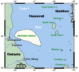
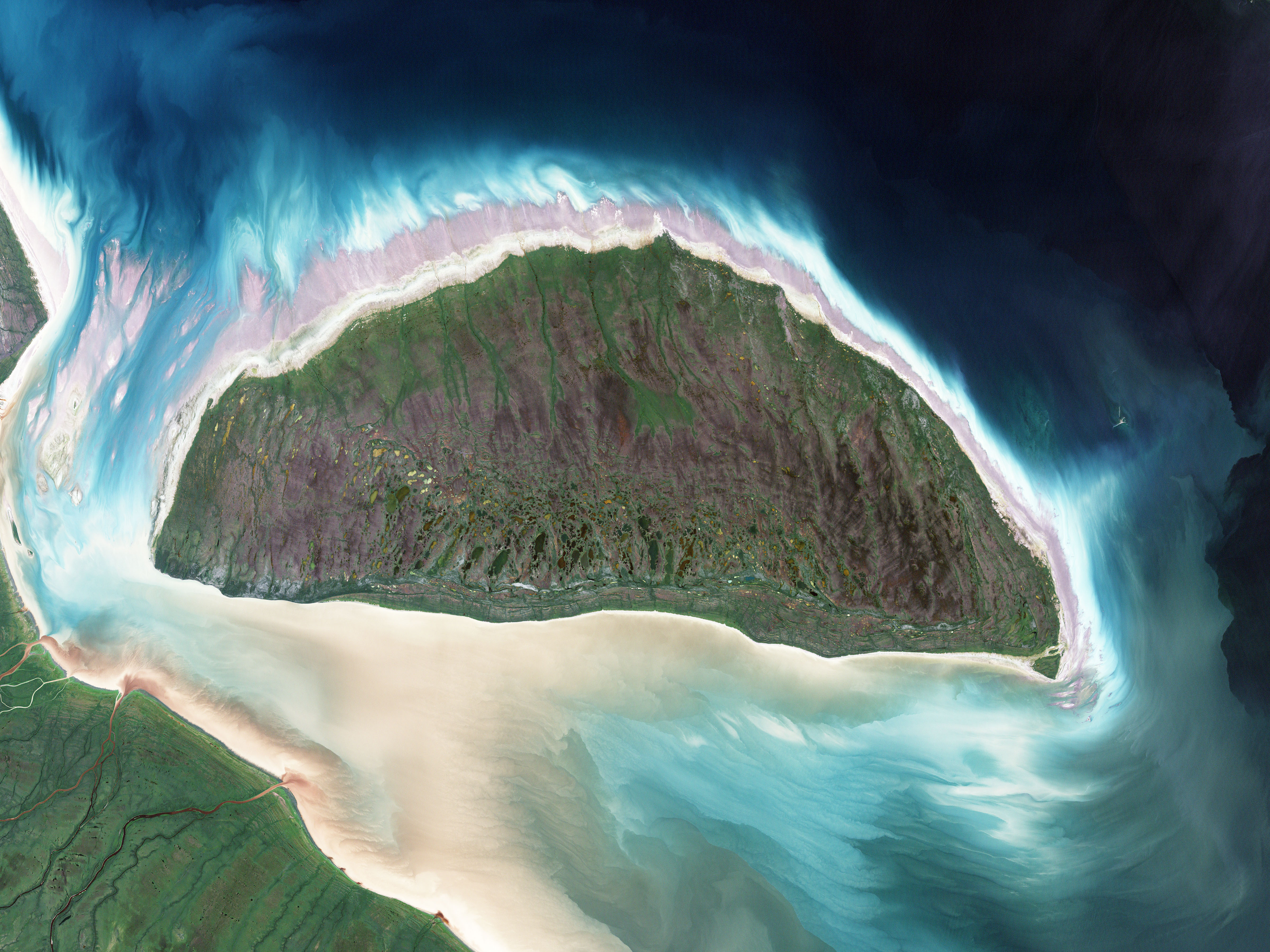
Akimiski Island[1] is the largest island in James Bay (a southeasterly extension of Hudson Bay), Canada, which is part of the Qikiqtaaluk Region of the territory of Nunavut. It has an area of 3,001 km2 (1,159 sq mi), making it the 163rd largest island in the world, and Canada's 29th largest island. Akimiski Island is 19 km (12 mi) from the province of Ontario. From the western side of the island, the Ontario coastline is visible.
 Closeup of Akimiski Island | |
 Akimiski Island  Akimiski Island | |
| Geography | |
|---|---|
| Location | Nunavut |
| Coordinates | 53°00′30″N 081°16′30″W[1] |
| Archipelago | Arctic Archipelago |
| Area | 3,001 km2 (1,159 sq mi) |
| Highest elevation | 34 m (112 ft) |
| Administration | |
Canada | |
| Territory | Nunavut |
| Region | Qikiqtaaluk |
| Demographics | |
| Population | Uninhabited |
The island's name is Swampy Cree[1] for "land across the water".[2]
The island has no year-round human inhabitants; however, it is part of the Attawapiskat First Nation's traditional territory and is frequently used for traditional purposes. The surface of Akimiski is flat and slopes gradually to the north. Most of the vegetation that covers the island consists of lichen, moss, sedges, and dwarf black spruce. The island is a coastal wetland that includes mudflats, tidal marshes, and tidal mudflats. Freshwater streams that flow into southwestern James Bay carry sediments and abundant nutrients that help to sustain the productive waterfowl habitat around Akimiski Island.
The Akimiski Island Group includes Akimiski, Gasket, and Gullery islands; Albert Shoal; and the Akimiski Strait Isles.
Climate

- Mean annual temperature: 2.5 °C (36.5 °F)
- Average rainfall: 450 mm (17.72 in)
- Average snowfall: 25 cm (9.84 in)[3]
| Climate data for Akimiski Island | |||||||||||||
|---|---|---|---|---|---|---|---|---|---|---|---|---|---|
| Month | Jan | Feb | Mar | Apr | May | Jun | Jul | Aug | Sep | Oct | Nov | Dec | Year |
| Average high °C (°F) | −14 (7) |
−12 (10) |
−6 (21) |
1 (34) |
10 (50) |
17 (63) |
19 (66) |
19 (66) |
13 (55) |
6 (43) |
−1 (30) |
−9 (16) |
4 (38) |
| Average low °C (°F) | −23 (−9) |
−22 (−8) |
−16 (3) |
−7 (19) |
−1 (30) |
3 (37) |
6 (43) |
8 (46) |
5 (41) |
1 (34) |
−6 (21) |
−17 (1) |
−6 (22) |
| Average precipitation mm (inches) | 23 (0.9) |
18 (0.7) |
30 (1.2) |
35 (1.4) |
44 (1.7) |
57 (2.2) |
58 (2.3) |
56 (2.2) |
55 (2.2) |
60 (2.4) |
45 (1.8) |
27 (1.1) |
508 (20.1) |
| Source: [4] | |||||||||||||
Conservation
Akimiski Island is the site of the Akimiski Island Migratory Bird Sanctuary, a Canadian Important Bird Area, site #NU036 (53°10′12″N 081°19′48″W). Its eastern portion is also a federal Migratory Bird Sanctuary, and much of the coastline is a Key Migratory Bird Terrestrial Habitat site.[3]
Fauna
The coastal waters and wetlands of Akimiski Island (and James Bay in general) are important feeding grounds for many varieties of migratory birds.[5] Notable species include:[3]
- Atlantic brant
- Canada goose
- Lesser snow goose
- Marbled godwit
- Semipalmated sandpiper
Because James Bay and Hudson Bay are funnel-shaped, migrating birds from the Arctic concentrate in this area. During fall migration, an abundance of birds with both adults and young are present. In the springtime, the birds tend to reside in the southern areas of James Bay until the northern section thaws.
Among mammals, ringed seals, polar bears, and beluga whales can be found in the area.[6]
References
- "Akimiski Island". Geographical Names Data Base. Natural Resources Canada. Retrieved 2020-06-15.
- "Akimiski Island, Nunavut, Canada: An Island in Dispute", Collections Canada
- "Akimiski Island James Bay, Nunavut". bsc-eoc.org. Archived from the original on 2011-06-12. Retrieved 2009-04-22.
- "Records and Averages for Akimiski Island". Meteoblue.com. Climate ID: 2400600. Retrieved 2021-11-28.
- Reiter, Matthew E. (February 2006). "Sympatric nesting eastern prairie population Canada Geese and Lesser Snow Geese" (PDF). umn.edu. Retrieved 2008-05-09. [dead link]
- Canada, Environment and Climate Change. "Akimiski Island Migratory Bird Sanctuary - Canada.ca". www.ec.gc.ca. Archived from the original on 2017-09-18. Retrieved 9 April 2018.
Further reading
- Hill, Michael Robert John. Factors Influencing Pre- and Post-Fledging Growth and Survival of Canada Goose Goslings on Akimiski Island, Nunavut. Ottawa: National Library of Canada = Bibliothèque nationale du Canada, 2000. ISBN 0-612-42527-4
- Martini, I. P.; Glooschenko, W. A. (1984). "Emergent coasts of Akimiski Island, James Bay, Northwestern Territories, Canada: geology, geomorphology, and vegetation". Sedimentary Geology. 37 (4): 229–250. Bibcode:1984SedG...37..229M. doi:10.1016/0037-0738(84)90016-2.
- C.S. Blaney; P.M. Kotanen (2000). "The vascular flora of Akimiski Island, Nunavut Territory, Canada" (PDF). Canadian Field-Naturalist. 115 (1): 88–98. ISSN 0008-3550. Wikidata Q113676664.
External links
- NASA Photo : "STS085-713-070 Akimiski Island, Northwest Territory, Canada August 1997 Akimiski Island, a 2000-square-mile (5180 square kilometers) uninhabited island, is the largest island in James Bay (a southeasterly extension of Hudson Bay)."
На других языках
[de] Akimiski Island
Akimiski Island ist eine kanadische Insel und mit einer Ausdehnung von ungefähr 99,3 × 40,7 km und einer Fläche von 3.001 km²[1] die größte Insel in der James Bay, dem südlichen Ausläufer der Hudson Bay. Sie ist sumpfig und relativ flach. Ihre höchste Erhebung liegt im Südwesten bei 34 Metern über dem Meer.[2]- [en] Akimiski Island
[es] Isla Akimiski
La Isla Akimiski (Akimiski Island) es la isla más grande de la Bahía de James (área sudeste de la Bahía de Hudson), Canadá, que forma parte de la Región Qikiqtaaluk del territorio de Nunavut.[fr] Île Akimiski
L'île Akimiski est une île de la Baie James au Canada. Elle appartient au territoire du Nunavut et n'est pas habitée. Elle a une superficie de 3 000 km2. Sa partie ouest se trouve à seulement 19 km de l'Ontario et sa partie orientale est un sanctuaire pour les oiseaux migrateurs, le refuge d'oiseaux de l'Île Akimiski, des ressources alimentaires importantes s'y trouvant[1].[it] Akimiski
Akimiski è la maggiore isola della Baia di James (un'estensione a sud-est della Baia di Hudson) in Canada.[ru] Акимиски
Остров Акимиски (англ. Akimiski Island) — крупнейший остров в заливе Джеймс (Канада)[1]. Входит в состав региона Кикиктани территории Нунавут Канады.Другой контент может иметь иную лицензию. Перед использованием материалов сайта WikiSort.org внимательно изучите правила лицензирования конкретных элементов наполнения сайта.
WikiSort.org - проект по пересортировке и дополнению контента Википедии