geo.wikisort.org - Sea
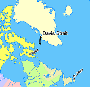
Davis Strait is a northern arm of the Atlantic Ocean that lies north of the Labrador Sea. It lies between mid-western Greenland and Baffin Island in Nunavut, Canada. To the north is Baffin Bay. The strait was named for the English explorer John Davis (1550–1605), who explored the area while seeking a Northwest Passage. By the 1650s it was used for whale hunting.
Extent
The International Hydrographic Organization defines the limits of the Davis Strait as follows:[1]
On the North. The Southern limit of Baffin Bay [The parallel of 70° North between Greenland and Baffin Land].
On the East. The Southwest coast of Greenland.
On the South. The parallel of 60° North between Greenland and Labrador.
On the West. The Eastern limit of the Northwestern Passages South of 70° North [the East coast of Baffin Island to East Bluff, its Southeastern extremity] and of Hudson Strait [A line from East Bluff, the Southeast extreme of Baffin Island (61°53′N 65°57′W), to Point Meridian, the Western extreme of Lower Savage Islands, along the coast to its Southwestern extreme and thence a line across to the Western extreme of Resolution Island, through its Southwestern shore to Hatton Headland, its Southern point, thence a line to Cape Chidley, Labrador (60°24′N 64°26′W)].
Geology

The Davis Strait is underlain by complex geological features of buried grabens (basins) and ridges, formed by strike-slip faulting of the Ungava Fault Zone during Paleogene times about 45 million to 62 million years ago. The strike-slip faulting transferred plate-tectonic motions in the Labrador Sea to Baffin Bay. It is the world's broadest strait.
Depth
With a water depth of between one and two thousand meters the strait is substantially shallower than the Labrador Sea to the south.
Tides
The strait is famous for its fierce tides that can range from 30 to 60 ft (9.1 to 18.3 m), which discouraged many earlier explorers.[citation needed]
Oil and gas
US Geological Survey has estimated that at least 13% of the world's undiscovered oil deposits and 30% of the world's undiscovered gas pockets are located in the Arctic, with the seas around Greenland potentially holding large amounts of natural gas and lesser amounts of crude oil and natural gas liquids.[2][3] This has led Greenland's minister and provincial council to offer a large number of off-shore concessions to potential hydrocarbon (oil and gas) extraction. The largest concessions areas are located in seas west of Greenland, primarily the Davis Strait and Baffin Bay, but with several smaller concessions in the Greenland Sea in the east also.[4][5][6][7]
References
- "Limits of Oceans and Seas, 3rd edition" (PDF). International Hydrographic Organization. 1953. Retrieved 28 December 2020.
- "90 Billion Barrels of Oil and 1,670 Trillion Cubic Feet of Natural Gas Assessed in the Arctic". US Geological Survey (USGS). 23 July 2008. Retrieved 17 April 2016.
- "Assessment of Undiscovered Oil and Gas Resources of the West Greenland" (PDF). US Geological Survey (USGS). May 2008. Retrieved 17 April 2016.
- Lisa Gregoire (15 May 2014). "Greenland pushing ahead with oil and gas development". Nunatsiaq Online. Nunatsiaq News. Retrieved 17 April 2016.
- "Current Licences". Bureau of Mineral and Petroleum (Greenland). Archived from the original on 13 May 2016. Retrieved 17 April 2016.
- "Map of exclusive hydrocarbon licences" (PDF). Bureau of Mineral and Petroleum (Greenland). February 2016. Archived from the original (PDF) on 13 May 2016. Retrieved 17 April 2016.
- "Approved Hydrocarbon Activities". Bureau of Mineral and Petroleum (Greenland). 31 October 2015. Archived from the original on 13 May 2016. Retrieved 17 April 2016.
Further reading
- Boertmann, David. Mapping of Oil Spill Sensitive Areas in the Davis Strait, West Greenland A Review of Biological Data in Relation to Oil Spill Sensitivity Mapping, with an Identification of Data Gaps. Copenhagen, Denmark: Greenland Environmental Research Institute, 1992.
- Crawford, R. E. Life History of the Davis Strait Greenland Halibut, with Reference to the Cumberland Sound Fishery. Winnipeg: Dept. of Fisheries and Oceans, 1992.
- Drüe, C.; Heinemann, G. (2001). "Airborne Investigation of Arctic Boundary-Layer Fronts over the Marginal Ice Zone of the Davis Strait". Boundary-Layer Meteorology. 101 (2): 261–292. Bibcode:2001BoLMe.101..261D. doi:10.1023/A:1019223513815. S2CID 117719555.
- Heide-Jørgensen, M.P.; Stern, H.; Laidre, K.L. (2007). "Dynamics of the sea ice edge in Davis Strait". Journal of Marine Systems. 67 (1–2): 170–178. Bibcode:2007JMS....67..170H. doi:10.1016/j.jmarsys.2006.10.011.
- Credland, Arthur (1998). "The Greenland and Davis Strait trade 1740–1880. A.G.E. Jones. 1997. Bluntisham: Bluntisham Books, xxxiii + 230 p, hard cover. ISBN 1-871999-08-1". Polar Record. 34 (189): 162–163. doi:10.1017/S0032247400015400.
- Jørgensen, O. A.; Hvingel, C.; Møller, P. R.; Treble, M. A. (2005). "Identification and mapping of bottom fish assemblages in Davis Strait and southern Baffin Bay". Canadian Journal of Fisheries and Aquatic Sciences. 62 (8): 1833–1852. doi:10.1139/f05-101.
- Mallory, Mark L.; Roberston, Gregory J.; Moenting, Alissa (2006). "Marine plastic debris in northern fulmars from Davis Strait, Nunavut, Canada". Marine Pollution Bulletin. 52 (7): 813–815. doi:10.1016/j.marpolbul.2006.04.005. PMID 16753186.
- Ross, W. Gillies. Arctic Whalers, Icy Seas Narratives of the Davis Strait Whale Fishery. Toronto, Canada: Irwin Pub, 1985. ISBN 0-7725-1524-7
External links
- June 2005 satellite photograph of Davis Strait from MODIS, showing meltwater ponds
Authority control | |
|---|---|
| General |
|
| National libraries | |
| Other |
|
На других языках
[de] Davisstraße
Die Davisstraße (englisch Davis Strait, dänisch Davisstrædet) ist die Meerenge zwischen der kanadischen Baffininsel und Grönland. Sie verbindet die Labradorsee mit der Baffin Bay. Sie ist 700 km lang, und 300 km breit und damit eine der breitesten Meerengen der Welt. Größter Ort an der Davisstraße ist Sisimiut, die zweitgrößte Stadt Grönlands.- [en] Davis Strait
[es] Estrecho de Davis
El estrecho de Davis (en inglés, Davis Strait; en francés, Détroit de Davis; y en danés, Davisstrædet), es un estrecho marino que se encuentra entre la costa occidental de Groenlandia y la costa oriental de la isla de Baffin, la mayor de las islas del archipiélago ártico canadiense.[ru] Девисов пролив
Де́висов проли́в[1][2][3], или проли́в Де́йвиса[3][4][5] (англ. Davis Strait, фр. Détroit de Davis, дат. Davisstrædet) — пролив, разделяющий Гренландию и остров Баффинова Земля (канадская провинция Нунавут).Другой контент может иметь иную лицензию. Перед использованием материалов сайта WikiSort.org внимательно изучите правила лицензирования конкретных элементов наполнения сайта.
WikiSort.org - проект по пересортировке и дополнению контента Википедии