geo.wikisort.org - Island
Rowley Island is one of the Canadian Arctic islands in the Qikiqtaaluk Region, Nunavut. It is located in Foxe Basin and has an area of 1,090 km2 (420 sq mi).
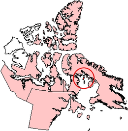 Rowley Island, Nunavut. | |
 Rowley Island  Rowley Island | |
| Geography | |
|---|---|
| Location | Foxe Basin |
| Coordinates | 69°09′N 78°52′W[1] |
| Archipelago | Arctic Archipelago |
| Area | 1,090 km2 (420 sq mi) |
| Administration | |
Canada | |
| Territory | Nunavut |
| Region | Qikiqtaaluk |
| Demographics | |
| Population | 62[3] (2016) |
Although the island is uninhabited there is both an unmanned Distant Early Warning Line base, called FOX-1 at 69°04′01″N 079°03′54″W, and an Automated Surface Observing System.
It is named after the arctic explorer Graham Westbrook Rowley.
References
- "Rowley Island". Geographical Names Data Base. Natural Resources Canada.
- "Rowley Island". Geographical Names Data Base. Natural Resources Canada.
- Population for Dissemination block 62040059002, 2016 Canada Census
External links
This Qikiqtaaluk Region, Nunavut location article is a stub. You can help Wikipedia by expanding it. |
На других языках
[de] Rowley Island
Rowley Island ist eine Insel im Kanadisch-arktischen Archipel in der Qikiqtaaluk-Region des kanadischen Territorium Nunavut.- [en] Rowley Island
[fr] Île Rowley (Canada)
L'île Rowley (Rowley Island en anglais) est une île inhabitée située dans le bassin de Foxe, à proximité de l'île de Baffin. Sa superficie est de 1 090 km2. Cette île porte le nom de l'explorateur anglais Graham Westbrook Rowley[1].[it] Isola Rowley
L'isola Rowley è un'isola del Canada.[ru] Роули (остров)
Роули (англ. Rowley Island) — остров Канадского Арктического архипелага.Текст в блоке "Читать" взят с сайта "Википедия" и доступен по лицензии Creative Commons Attribution-ShareAlike; в отдельных случаях могут действовать дополнительные условия.
Другой контент может иметь иную лицензию. Перед использованием материалов сайта WikiSort.org внимательно изучите правила лицензирования конкретных элементов наполнения сайта.
Другой контент может иметь иную лицензию. Перед использованием материалов сайта WikiSort.org внимательно изучите правила лицензирования конкретных элементов наполнения сайта.
2019-2026
WikiSort.org - проект по пересортировке и дополнению контента Википедии
WikiSort.org - проект по пересортировке и дополнению контента Википедии