geo.wikisort.org - Coast
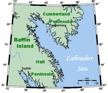
Cumberland Peninsula is a peninsula in the southeastern part of Baffin Island in Nunavut, Canada. It is located between 64°56' and 67°57' north latitude, and 61°56' to 68° west longitude.[1] The Arctic Circle crosses the peninsula, with the Labrador Sea to the southeast, and the Davis Strait to the east, which lies between the peninsula and Greenland. The Cumberland Sound lies to the southwest, separating the Cumberland Peninsula from the Hall Peninsula, which is also part of Baffin Island.

The Cumberland Peninsula is part of the Arctic Tundra biome—the world's coldest and driest biome—as is the rest of Baffin Island. The terrain is mountainous, and Mt. Odin, near the Arctic Circle, rises 7,044 ft (2,147 m).
The peninsula is home to Pangnirtung, which lies on the southwest coast, and the Auyuittuq National Park.
References
- "Cumberland Peninsula". The Columbia Gazetteer of North America. bartleby.com. 2000. Archived from the original on 2005-05-11. Retrieved 2008-10-20.
Further reading
- Dyke, Arthur S., John T. Andrews, and Gifford H. Miller. Quaternary Geology of Cumberland Peninsula, Baffin Island, District of Franklin. Ottawa, Canada: Geological Survey of Canada, 1982. ISBN 0-660-11182-9
External links
| Wikimedia Commons has media related to Cumberland Peninsula. |
- Aerial photos of Cumberland Peninsula by Doc Searls
| Authority control |
|
|---|
This Qikiqtaaluk Region, Nunavut location article is a stub. You can help Wikipedia by expanding it. |
Другой контент может иметь иную лицензию. Перед использованием материалов сайта WikiSort.org внимательно изучите правила лицензирования конкретных элементов наполнения сайта.
WikiSort.org - проект по пересортировке и дополнению контента Википедии