geo.wikisort.org - Mountains
Precipice Peak is a 13,144-foot-elevation (4,006 meter) mountain summit located in Hinsdale County, of Colorado, United States.[3] It is situated 10.5 miles northeast of the community of Ouray, in the Uncompahgre Wilderness, on land managed by Uncompahgre National Forest. It is part of the San Juan Mountains which is a subset of the Rocky Mountains, and is situated west of the Continental Divide. Topographic relief is significant as the west aspect rises 2,500 feet (760 meters) above the West Fork Cimarron River valley in approximately one mile. Neighbors include Dunsinane Mountain three-quarters of a mile north, Courthouse Mountain 2.4 miles northwest, and Redcliff 2.2 miles south. The mountain's name was officially adopted by the United States Board on Geographic Names in 1966.[3] It is so named because of a very prominent precipice on the mountain's east face.[5]
| Precipice Peak | |
|---|---|
 Northwest aspect | |
| Highest point | |
| Elevation | 13,144 ft (4,006 m)[1] |
| Prominence | 464 ft (141 m)[1] |
| Parent peak | Fortress Peak (13,241 ft)[2] |
| Isolation | 1.52 mi (2.45 km)[2] |
| Coordinates | 38°07′09″N 107°32′08″W[3] |
| Naming | |
| Etymology | Precipice |
| Geography | |
 Precipice Peak Location in Colorado  Precipice Peak Precipice Peak (the United States) | |
| Location | Hinsdale County Colorado, US |
| Parent range | Rocky Mountains San Juan Mountains |
| Topo map | USGS Wetterhorn Peak |
| Climbing | |
| Easiest route | class 2+[2] W slope, south ridge[4] |
Climate
According to the Köppen climate classification system, Precipice Peak is located in an alpine subarctic climate zone with cold, snowy winters, and cool to warm summers.[6] Due to its altitude, it receives precipitation all year, as snow in winter, and as thunderstorms in summer, with a dry period in late spring. Precipitation runoff from the mountain drains into tributaries of the Cimarron River.
Gallery
 Precipice Peak centered, with Dunsinane Mountain on left. Camera pointed east.
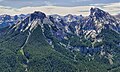 Dunsinane Mountain on the left, with Precipice Peak on the right. West aspect.
 Dunsinane and Precipice centered, Redcliff to far right


See also
- Mountains of Hinsdale County, Colorado
References
- "Precipice Peak, Colorado". Peakbagger.com.
- "Precipice Peak - 13,144' CO". listsofjohn.com. Retrieved 2021-06-30.
- "Precipice Peak". Geographic Names Information System. United States Geological Survey. Retrieved 2021-06-30.
- Robert F. Rosebrough, The San Juan Mountains: A Climbing & Hiking Guide, Cordillera Press, 1986, page 224.
- United States Board on Geographic Names, Decisions on Geographic Names in the United States, Decision List No. 6602, 1966, page 9.
- Peel, M. C.; Finlayson, B. L.; McMahon, T. A. (2007). "Updated world map of the Köppen−Geiger climate classification". Hydrol. Earth Syst. Sci. 11. ISSN 1027-5606.
External links
- Weather forecast: Precipice Peak
Другой контент может иметь иную лицензию. Перед использованием материалов сайта WikiSort.org внимательно изучите правила лицензирования конкретных элементов наполнения сайта.
WikiSort.org - проект по пересортировке и дополнению контента Википедии