geo.wikisort.org - Mountains
American Peak is a 13,806-foot-elevation (4,208 meter) mountain summit located in Hinsdale County, of southwest Colorado, United States.[3] It is situated 11 miles northeast of the community of Silverton, on land managed by the Bureau of Land Management. It is part of the San Juan Mountains which is a subset of the Rocky Mountains, and is situated four miles west of the Continental Divide. American Peak ranks as the 102nd-highest peak in Colorado,[2] and topographic relief is significant as the south aspect rises 2,800 feet (853 meters) above Snare Creek in approximately 1.5 mile. Neighbors include Handies Peak one mile to the north-northeast, and Jones Mountain, 0.8 mile to the west-southwest. The mountain's name was officially adopted in 2005 by the United States Board on Geographic Names to recognize the American spirit and heritage, and the summit's proximity to American Basin.[3]
| American Peak | |
|---|---|
 North aspect, with Sloan Lake | |
| Highest point | |
| Elevation | 13,806 ft (4,208 m)[1] |
| Prominence | 446 ft (136 m)[1] |
| Parent peak | Jones Mountain (13,866 ft)[2] |
| Isolation | 0.79 mi (1.27 km)[2] |
| Coordinates | 37°53′58″N 107°30′45″W[3] |
| Geography | |
 American Peak Location in Colorado  American Peak American Peak (the United States) | |
| Location | Hinsdale County Colorado, US |
| Parent range | Rocky Mountains San Juan Mountains |
| Topo map | USGS Handies Peak |
| Climbing | |
| Easiest route | class 2[2] West ridge |
Climate
According to the Köppen climate classification system, American Peak is located in an alpine subarctic climate zone with cold, snowy winters, and cool to warm summers.[4] Due to its altitude, it receives precipitation all year, as snow in winter, and as thunderstorms in summer, with a dry period in late spring. Precipitation runoff from the mountain drains into tributaries of the Gunnison River.
Gallery
 American Peak, north aspect, from slopes of Handies Peak
 American Peak left of center, from top of Handies. (Jones Mtn upper right corner)
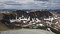 American Peak left of center, from top of Handies Peak. (Jones Mtn upper right)


See also
- Mountains of Hinsdale County, Colorado
References
- "American Peak, Colorado". Peakbagger.com.
- "American Peak - 13,806' CO". listsofjohn.com. Retrieved 2021-07-04.
- "American Peak". Geographic Names Information System. United States Geological Survey. Retrieved 2021-07-04.
- Peel, M. C.; Finlayson, B. L.; McMahon, T. A. (2007). "Updated world map of the Köppen−Geiger climate classification". Hydrol. Earth Syst. Sci. 11. ISSN 1027-5606.
External links
- Weather forecast: American Peak
Другой контент может иметь иную лицензию. Перед использованием материалов сайта WikiSort.org внимательно изучите правила лицензирования конкретных элементов наполнения сайта.
WikiSort.org - проект по пересортировке и дополнению контента Википедии