geo.wikisort.org - Island
This is a list of islands of Italy. There are over 400 islands in Italy, including islands in the Mediterranean Sea (including the marginal seas: Adriatic Sea, Ionian Sea, Libyan Sea, Ligurian Sea, Sea of Sardinia, Tyrrhenian Sea, and inland islands in lakes and rivers. The largest island is Sicily with an area of 25,711 km2 (9,927 sq mi). The outlying islands of Italy make up an official region of Insular Italy with an area of 49,801 km2 (19,228 sq mi).[1][2]
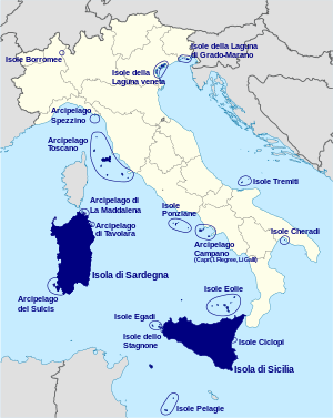
Insular Italy
Italy has a coastline and border of 7,600 km (4,700 mi) on the Mediterranean Sea. The following sections list the islands by coastal region, major island, lagoon, or archipelago.[3]
Calabria

Islands off the coast of Calabria include:
- Le Castella - 38°54′32″N 17°01′24″E
- Cirella - 39°41′56″N 15°48′07″E
- Coreca Reefs - 39°05′41″N 16°04′49″E
- Isola di Dino (uninhabited) - 39°52′26″N 15°46′30″E
- Formiche Skerries - 38°39′35″N 15°50′43″E
- Galea Skerries - 38°36′22″N 15°50′59″E
- Galera Skerries - 39°59′53″N 16°36′41″E
- Godano Skerry - 38°38′20″N 15°49′34″E
- Grilla Skerry -40°01′12″N 16°36′26″E
- Incudine Skerry - 39°58′50″N 16°37′04″E
- Isca Skerries - 39°08′52″N 16°03′27″E
- Monaca Skerry - 38°43′38″N 16°01′11″E
- Oremus Skerries - 39°37′17″N 15°50′49″E
- Palombaro Skerry - 38°41′06″N 15°55′11″E
- Pietra Galera Skerry - 38°20′25″N 15°49′47″E
- Pietra Grande Skerry - 38°45′11″N 16°34′03″E
- Ringa Skerries, 38°41′04″N 15°55′01″E
- Safò Skerries - 38°43′19″N 16°03′57″E
- Regina Skerries, 39°28′07″N 15°58′13″E
- Santo Ianni - 39°58′02″N 15°42′57″E
- Cervaro Skerry - 40°04′38″N 16°36′19″E
- Scorzone Skerry - 39°51′24″N 15°47′20″E
- Riaci Skerries, 38°40′17″N 15°52′07″E
- Trachini Skerry, 38°22′45″N 15°51′23″E
- Ulivo Skerry - 38°22′53″N 15°51′25″E
- Vrace Skerry - 38°43′38″N 16°01′17″E
Campanian Archipelago
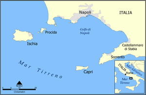
Islands in the Campanian Archipelago include:
- Flegrean Isles
- Capri - 40°33′00″N 14°14′00″E
- Capri Faraglioni rocks - 40°32′24″N 14°15′11″E
- Monacone Skerry - 40°32′37″N 14°15′24″E
- Unghia Marina Skerry - 40°32′44″N 14°14′43″E
- Ischia (8th largest island at 46 km2 (18 sq mi)[2]) - 40°43′52″N 13°53′45″E
- Aragonese Castle - 40°43′54″N 13°57′53″E
- La Nave Skerry - 40°42′26″N 13°51′13″E
- Lorio Skerry - 40°44′07″N 13°51′08″E
- Sant'Anna Skerries - 40°43′37″N 13°57′40″E
- Levante Skerry - 40°47′41″N 14°10′00″E
- Ponente Skerry - 40°47′53″N 14°09′37″E
- Capri - 40°33′00″N 14°14′00″E
- Gaiola - 40°47′30″N 14°11′13″E
- Li Galli - 40°34′52″N 14°25′59″E
- Castelluccia Islet - 40°34′54″N 14°25′47″E
- Gallo Lungo - 40°34′57″N 14°26′07″E
- Nisida - 40°47′43″N 14°09′48″E
- Rotonda Islet - 40°34′48″N 14°25′48″E
- Isola Licosa - 40°15′05″N 14°54′01″E
- Megaride - 40°49′41″N 14°14′54″E
- Pennata - 40°47′32″N 14°05′19″E
- Procida - 40°45′30″N 14°01′00″E
- Rovigliano Skerry - 40°43′46″N 14°27′49″E
- San Martino - 40°47′56″N 14°02′12″E
- Vervece Skerry - 40°37′08″N 14°19′29″E
- Vetara Skerry - 40°35′00″N 14°23′51″E
Cheradi Islands
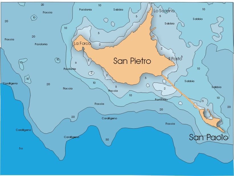
The Cheradi Islands include:
- Campo Islet - 40°03′14″N 17°58′09″E
- Gallipoli - 40°03′20″N 17°59′30″E
- San Paolo - 40°26′19″N 17°10′31″E
- San Pietro - 40°26′58″N 17°09′23″E
- Sant'Andrea - 40°02′56″N 17°56′59″E
Grado Lagoon
There are nearly 120 islands in the Marano Grado Lagoon of the Adriatic Sea, including:
- Anfora Island (canal) - 45°45′14″N 13°16′19″E
- Barbana - 45°42′12″N 13°25′23″E
- Fossalon Island near Grado - 45°40′40″N 13°23′41″E
- Isola di Grado - 45°40′49″N 13°25′05″E
- Isola Morgo, 45°42′24″N 13°19′01″E
- San Pietro d'Orio - 45°41′28″N 13°21′02″E
- Schiusa Island (canal) - 45°41′00″N 13°24′00″E
Gulf of La Spezia

Islands in the Gulf of La Spezia include:
- Ferale Skerry - 44°04′16″N 9°46′52″E
- Palmaria[2][4] - 44°02′34″N 9°50′38″E
- Scola - 44°03′06″N 9°51′30″E
- Tinetto[2] - 44°01′25″N 9°51′04″E
- Tino[2] - 44°01′37″N 9°51′03″E
Ligurian Islands

The Italian islands in the Ligurian Sea include:
- Bergeggi (uninhabited 44°14′04″N 8°26′42″E
- Gallinara (private) - 44°01′32″N 8°13′35″E
Marano Lagoon
Islands in the Marano Lagoon include:
- Isola Marinetta - 45°42′24″N 13°09′44″E
- Martignano Island - 45°42′24″N 13°10′29″E
- Isola Sant'Andrea - 45°42′55″N 13°12′58″E
Pedagne peninsula
Islands in the Pedagne Peninsula include:
- Isola Traversa - 40°39′28″N 17°59′27″E
- Isola Chiesa - 40°39′22″N 17°59′38″E[5]
- Isla Monacello - 40°39′28″N 17°59′30″E[5]
- Isole Pedagne, 40°39′16″N 18°00′01″E
- Isole Pedagne Grande - 40°39′16″N 18°00′11″E
Pontine Islands

Islands in the Pontine Islands arechipieligo (Tyrrhenian Sea) include:
- Isolo di Gavi (uninhabited) - 40°56′07″N 13°00′03″E
- Le Scoglitelle Skerries - 40°56′16″N 13°00′35″E
- Piana di Mezzo Skerry - 40°56′31″N 13°01′00″E
- Rosso Skerry - 40°56′48″N 13°01′29″E
- Palmarola - 40°56′13″N 12°51′29″E
- Faraglioni di Mezzogiorno - 40°55′24″N 12°50′53″E
- Forcina Skerry - 40°56′18″N 12°51′41″E
- I Piatti Skerries - 40°56′52″N 12°51′00″E
- Pallante Skerry - 40°55′43″N 12°50′56″E
- Scuncillo Skerry - 40°57′02″N 12°51′14″E
- Suvace Skerry - 40°55′38″N 12°51′37″E
- Ponza - 40°54′27″N 12°57′09″E
- Aniello Antonio Skerry - 40°55′21″N 12°58′38″E
- Cantina Skerries - 40°55′26″N 12°57′59″E
- Faraglioni della Madonna - 40°53′40″N 12°58′22″E
- Faraglioni di Calzo - 40°53′05″N 12°57′55″E
- Faraglioni di Maria Rosa - 40°54′45″N 12°56′45″E
- Felce Skerries - 40°56′06″N 12°59′28″E
- Montagnello Skerry - 40°54′13″N 12°56′36″E
- Ravia Skerry - 40°54′00″N 12°57′56″E
- Rosso Skerry - 40°53′51″N 12°58′22″E
- Santo Stefano - 40°47′22″N 13°27′15″E
- Ventotene - 40°47′37″N 13°25′33″E
- Nave Skerry - 40°47′42″N 13°26′05″E
- Zannone (uninhabited) - 40°58′14″N 13°03′18″E
Porto Cesareo lagoon

Islands in the Porto Cesareo lagoon (40°15′11″N 17°54′05″E) include:
- Conigli - 40°15′36″N 17°53′01″E
- Lo Scoglio - 40°15′20″N 17°53′28″E
- Malva - 40°16′12″N 17°52′00″E
- Isola della Testa - 40°15′13″N 17°53′25″E
- Russa Skerry - 40°00′29″N 16°36′41″E
- Sant'Isidoro - 40°13′08″N 17°55′16″E
Sardinia
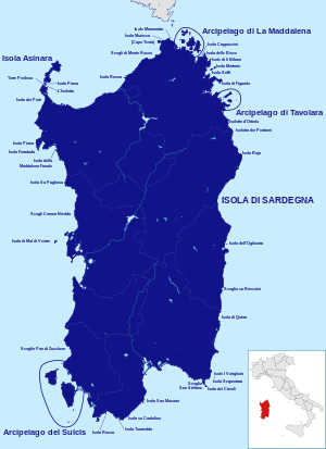

Sardinia is the second largest island (24,089 km2 (9,301 sq mi)[2]) (40°00′00″N 9°00′00″E) and includes the following outlying islands:
- Agusteri Skerries - 39°18′44″N 8°25′37″E
- Bocca - 40°55′14″N 9°34′01″E
- Asinara (7th largest island at 51 km2 (20 sq mi)[2])- 41°02′57″N 8°15′28″E
- Bocca Islet - 40°59′08″N 8°12′48″E
- Candelere Islets - 41°03′06″N 8°15′02″E
- Piana Island - 40°58′30″N 8°13′05″E
- Isolotto - 40°58′02″N 8°13′29″E
- Sgombro Islet - 41°01′43″N 8°15′08″E
- Barca Sconcia - 40°55′03″N 9°38′50″E
- Campionna - 38°54′52″N 8°45′56″E
- Cana Islet - 40°51′52″N 9°40′37″E
- Caogheddas - 39°54′15″N 8°23′49″E
- Cappucini Island - 41°09′12″N 9°30′07″E
- Catalano Skerry - 39°52′54″N 8°16′32″E
- Cau Islet - 41°04′29″N 9°35′14″E
- Cavalli Island - 40°53′08″N 9°38′25″E
- Cavoli - 39°05′12″N 9°31′54″E
- Colombaia Skerry - 41°13′58″N 9°16′45″E
- Coltellazzo - 38°59′06″N 9°01′23″E
- Corona Niedda Skerries - 40°12′36″N 8°27′18″E
- Cruccianas - 39°03′56″N 8°29′05″E
- delle Rocche Islet - 41°07′01″N 9°34′08″E
- de sa Scruidda - 39°04′59″N 8°30′35″E
- Faraglioni di Cea - 39°52′20″N 9°41′08″E
- Ferraglione Islets - 38°52′55″N 8°49′38″E
- Figarolo - 40°58′49″N 9°38′36″E
- Foradada Skerry - 40°34′14″N 8°09′05″E
- Geniò Skerry - 39°05′41″N 8°16′58″E
- Is Canneddas Skerry
- La Ghignetta Skerry - 39°11′59″N 8°22′10″E
- Maddalena archipelago
- Barrettinelli di Dentro - 41°16′32″N 9°24′11″E
- Barrettinelli di Fuori - 41°18′06″N 9°24′03″E
- Barrettini - 41°17′02″N 9°24′05″E
- Bisce Islet - 41°09′52″N 9°31′21″E
- Budelli (uninhabited)- 41°17′01″N 9°21′03″E
- Caprera - 41°12′26″N 9°27′40″E
- Italiani Islands - 41°13′33″N 9°27′20″E
- Pecora Islet - 41°10′58″N 9°29′08″E
- Porco Islet - 41°10′28″N 9°27′39″E
- Corcelli - 41°17′40″N 9°24′00″E
- La Maddalena - 41°14′09″N 9°24′52″E
- Abbatoggia - 41°15′12″N 9°23′59″E
- Chiesa Island - 41°12′50″N 9°25′03″E
- Giardinelli Island - 41°13′58″N 9°26′26″E
- Piana (La Maddalena) - 41°17′42″N 9°24′18″E
- Razzoli - 41°18′04″N 9°20′52″E
- Santa Maria (Sardinia) Island - 41°17′54″N 9°22′29″E
- Santo Stefano - 41°11′53″N 9°24′43″E
- Roma Islet - 41°11′47″N 9°23′48″E
- Spargi (uninhabited) - 41°14′28″N 9°20′43″E
- Spargiotto - 41°15′01″N 9°19′25″E
- Spargiottello Skerry - 41°15′06″N 9°19′15″E
- Mal di Ventre (private) - 39°59′26″N 8°18′17″E
- Marmorata Islets - 41°15′14″N 9°14′17″E
- Monte Russo Skerries - 41°09′29″N 9°07′11″E
- Morto Skerry - 39°18′18″N 8°18′17″E
- Mortorio - 41°04′37″N 9°36′15″E
- Mortoriotto Skerries - 41°05′10″N 9°37′06″E
- Municca Islet - 41°15′02″N 9°11′04″E
- Munichedda Skerry - 41°15′12″N 9°11′08″E
- Nibani Islands - 41°07′35″N 9°33′58″E
- Ogliastra Island - 39°58′27″N 9°42′12″E
- Pan di Zucchero Skerry - 39°20′02″N 8°24′02″E
- Patron Fiaso - 40°54′17″N 9°34′59″E
- Pedrami Islet - 40°41′06″N 9°46′01″E
- Peppino Skerry - 39°14′13″N 9°34′20″E
- Piana (Capo Caccia) - 40°36′13″N 8°08′28″E
- Piscadeddus Skerries - 39°07′27″N 9°27′54″E
- Porcu e Scriba - 39°04′05″N 8°29′43″E
- Porri Islet - 40°52′50″N 8°12′49″E
- Portisco Islet - 41°02′31″N 9°31′44″E
- Portolucas - 40°55′17″N 9°38′01″E
- Poveri Islets] - 41°05′38″N 9°34′51″E
- Quirra Islet - 39°31′29″N 9°39′32″E
- Rossa (Trinità d'Agultu e Vignola) - 41°00′51″N 8°51′48″E
- Rossa (Teulada) - 38°54′53″N 8°42′59″E
- Ruia Islet - 40°49′40″N 9°42′28″E
- Sa Craba Skerry - 40°19′14″N 8°26′30″E
- Sa Mesalonga - 40°02′46″N 8°23′48″E
- Sa Pagliosa Skerry - 40°21′37″N 8°22′39″E
- Sa Tonnara Skerry - 40°03′13″N 8°24′13″E
- San Macario - 39°00′12″N 9°01′56″E
- Sant'Elmo Skerry - 39°06′09″N 9°31′38″E
- Santo Stefano Skerry - 39°06′48″N 9°29′58″E
- Serpentara - 39°08′24″N 9°36′20″E
- Sarrala Skerry - 39°39′59″N 9°39′38″E
- Soffi - 41°03′52″N 9°34′32″E
- Le Camere Islets - 41°04′12″N 9°35′10″E
- Su Cardolinu - 38°53′53″N 8°53′26″E
- Su Giudeu - 38°52′56″N 8°51′54″E
- Su Scoglio Mannu - 39°13′36″N 8°21′23″E
- Su Scoglitteddu - 39°12′11″N 8°22′29″E
- Sulcis Archipelago
- Piana (Sulcis) - 39°11′30″N 8°19′15″E
- San Pietro (5th largest at 51 km2 (20 sq mi)[2]) - 39°08′57″N 8°16′09″E
- Cala Vinagra - 39°09′59″N 8°14′33″E
- Catena Skerry - 39°11′46″N 8°19′11″E
- Corno Islet - 39°08′51″N 8°12′28″E
- Ratti Island - 39°11′09″N 8°19′08″E
- Spine Skerries- 39°08′10″N 8°14′41″E
- Stea Skerry - 39°10′32″N 8°15′45″E
- Sant'Antioco (4th largest island at 109 km2 (42 sq mi)[2])- 39°02′41″N 8°25′01″E
- Manna Islet - 39°04′39″N 8°30′09″E
- Mangiabarche Skerry - 39°04′35″N 8°20′44″E
- Toro Islet - 38°51′42″N 8°24′34″E
- Vacca Islet - 38°56′14″N 8°26′59″E
- Vitello - 38°56′29″N 8°27′01″E
- Sant'Elia Skerry - 39°11′01″N 9°08′32″E
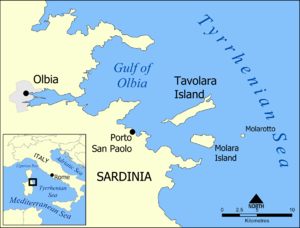
- Tavolara Islands[2] - 40°54′18″N 9°42′49″E
- Molara Island - 40°52′09″N 9°43′39″E
- Molarotto - 40°52′29″N 9°46′41″E
- Ogliastra Islet - 39°58′27″N 9°42′14″E
- Proratora - 40°50′48″N 9°43′24″E
- Quirra Skerry - 39°31′28″N 9°39′31″E
- Rosso Islet - 40°52′39″N 9°40′17″E
- Rujia Islet - 40°32′21″N 9°49′07″E
- Ratti Islet - 39°11′09″N 8°19′08″E
- Tuaredda - 38°53′30″N 8°48′48″E
Sicily
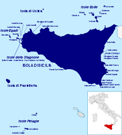


The island of Sicily (37°30′N 14°00′E) includes the following outlying islands:
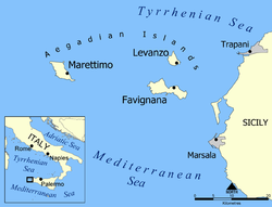
- Aegadian Islands include:
- Favignana - 37°55′34″N 12°19′16″E
- Galeotta Islet - 37°54′43″N 12°17′55″E
- Galera Islet - 37°54′52″N 12°17′25″E
- Palumbo Skerry - 37°54′52″N 12°18′40″E
- Preveto Islet - 37°54′52″N 12°18′08″E
- Formica Islet - 37°59′21″N 12°25′32″E
- Levanzo - 38°00′00″N 12°20′00″E
- Il Faraglione (it) - 37°59′12″N 12°19′43″E
- Isola Maraone (it) - 37°59′25″N 12°24′50″E
- Marettimo - 37°58′10″N 12°03′26″E
- Camello Skerry - 37°59′00″N 12°03′55″E
- Favignana - 37°55′34″N 12°19′16″E
- Augusta - 37°13′41″N 15°13′18″E
- Bella - 37°51′01″N 15°18′03″E
- Brolo Skerry - 38°09′54″N 14°49′32″E
- Capo Passero Island - 36°41′13″N 15°08′56″E
- Correnti Islet - 36°38′44″N 15°04′39″E
- Aeolian Islands islands include:[4][2]
- Alicudi[4] - 38°32′38″N 14°21′07″E
- Palomba Skerry - 38°31′57″N 14°21′37″E
- Basiluzzo - 38°39′48″N 15°06′50″E
- Bottaro Rock - 38°38′15″N 15°06′39″E
- Nave Skerry - 38°38′49″N 15°03′51″E
- Spinazzola Skerry - 38°39′52″N 15°06′29″E
- Filicudi[4] - 38°34′17″N 14°33′45″E
- Cuddurra Skerry - 38°34′11″N 14°32′37″E
- Fortuna Skerry - 38°34′26″N 14°32′24″E
- Giafante Skerry - 38°35′13″N 14°32′46″E
- La Canna Skerry - 38°34′57″N 14°31′16″E
- Mitra Skerry - 38°34′43″N 14°32′20″E
- Montenassari Skerry - 38°34′56″N 14°31′37″E
- Lipari (9th largest 37 km2 (14 sq mi)[2])[4] - 38°29′23″N 14°56′07″E
- Faraglioni of Lipari - 38°26′23″N 14°56′35″E
- Pietra del Bagno Skerry - 38°28′30″N 14°53′45″E
- Panarea[4] - 38°38′15″N 15°04′00″E
- Dattilo Islet - 38°38′22″N 15°05′50″E
- Le Formiche Skerries - 38°37′38″N 15°05′02″E
- Le Guglie Skerries - 38°38′21″N 15°05′46″E
- Lisca Bianca Islet - 38°38′21″N 15°06′50″E
- Lisca Nera Skerries - 38°38′05″N 15°06′24″E
- Panarelli Skerry - 38°38′32″N 15°05′59″E
- Salina (10th largest at 26 km2 (10 sq mi)[2])[4] - 38°33′55″N 14°50′00″E
- Faraglione Skerry - 38°34′46″N 14°48′03″E
- Stromboli[4] - 38°47′38″N 15°12′40″E
- Vulcano[2][4] - 38°23′58″N 14°57′50″E
- Quaglietto Stone - 38°24′00″N 14°56′19″E
- Sirene Skerry - 38°25′13″N 14°57′04″E
- Alicudi[4] - 38°32′38″N 14°21′07″E
- Asinelli Islet - 38°03′51″N 12°31′46″E
- Carabiniere Skerry - 37°04′42″N 15°17′51″E
- Castelluccio Skerries - 37°02′38″N 15°18′09″E
- Colombaia Islet - 38°00′41″N 12°29′36″E
- Cyclopean Isles islands include:
- Lachea - 37°33′41″N 15°10′00″E
- Faraglione Grande - 37°33′35″N 15°09′56″E
- Faraglione di Mezzo
- Faraglione degli Uccelli
- Faraglioni di Ciriga - 36°41′42″N 14°58′49″E
- Femmine Islet - 38°12′37″N 13°14′09″E
- Ferdinandea (submerged volcano) - 37°10′00″N 12°43′00″E
- Gucciarda Skerries - 37°17′28″N 13°27′08″E
- Iannuzzo Skerry - 36°41′07″N 14°58′31″E
- La Galera Skerry - 37°02′30″N 15°17′43″E
- Malconsiglio Skerry - 38°01′30″N 12°29′48″E
- Milocca Skerry - 37°00′16″N 15°16′53″E
- Ortygia - 37°03′42″N 15°17′41″E
- Ognina Islet - 36°58′45″N 15°15′49″E
- Palumbo Skerry (Trapani) - 38°00′45″N 12°29′19″E
- Pantelleria (5th largest island at 83 km2 (32 sq mi)[2]) - 36°47′20″N 11°59′38″E
- Faraglione di Dietro Isola - 36°45′25″N 12°03′11″E
- Faraglione di Tracino - 36°47′56″N 12°03′07″E
- Galera della Salina Skerry - 36°45′20″N 12°03′07″E
- Scoglietti Skerry - 36°44′07″N 12°01′34″E
- Patti Skerry - 38°09′39″N 14°59′32″E
- Patti Stone - 38°09′40″N 14°59′23″E
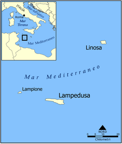
- Pelagian Islands include:
- Lampedusa - 35°30′56″N 12°34′23″E
- Conigli Islet - 35°30′37″N 12°33′30″E
- Faraglione - 35°31′44″N 12°32′39″E
- Pignolta Skerry - 35°31′37″N 12°31′25″E
- Sacramento Skerry - 35°31′44″N 12°31′42″E
- Lampione (uninhabited) - 35°33′06″N 12°19′18″E
- Linosa - 35°52′00″N 12°52′00″E
- Faraglioni di Linosa - 35°52′03″N 12°52′56″E
- Bovi Marini Skerries - 35°52′18″N 12°52′50″E
- Lampedusa - 35°30′56″N 12°34′23″E
- Palumbo Skerry (Trapani) - 38°00′45″N 12°29′19″E
- Piccola Islet - 36°44′18″N 15°07′08″E
- Pietra Patella Skerry - 37°11′23″N 13°39′25″E
- Pizzo Skerries - 37°04′19″N 15°17′53″E
- Porcelli Skerries - 38°02′38″N 12°26′22″E
- Porri (Sicily) - 36°41′11″N 14°55′55″E
- Rocca San Nicola Islet - 37°06′44″N 13°51′23″E
- San Biagio Skerry - 38°02′31″N 14°30′40″E
- Scialandro Skerry - 38°06′55″N 12°41′07″E
- Scibiliana Skerry - 37°43′50″N 12°28′10″E
- Stagnone Lagoon (Isolo dello Stagnone it) include:
- Isola Grande (it) - 37°52′54″N 12°26′33″E
- Isola La Scuola (it) - 37°51′46″N 12°27′24″E
- San Pantaleo - 37°52′06″N 12°28′07″E
- Isola Santa Maria (it) - 37°52′56″N 12°27′28″E
- Torre Avalos Islet - 37°12′42″N 15°13′27″E
- Scoglio Due Fratelli - 37°05′08″N 15°18′06″E
- Ustica - 38°42′19″N 13°10′34″E
- Colombara Skerry - 38°43′11″N 13°10′58″E
- Medico Skerry - 38°42′57″N 13°09′21″E
- Pastizza Skerry - 38°42′08″N 13°11′35″E
- Vendicari Islet - 36°47′31″N 15°06′19″E
- Vittoria Garcia Islet - 37°14′09″N 15°12′15″E
- Zio Gennaro Skerry - 37°51′34″N 15°18′08″E
Tremiti Islands

Islands in the Isole Tremiti are in the Adriatic Sea and include:
- Capraia - 42°08′13″N 15°30′47″E
- Isola San Domino - 42°06′53″N 15°29′15″E
- Isola San Nicola - 42°07′27″N 15°30′38″E
- Cretaccio - 42°07′21″N 15°29′59″E
- Isola Pianosa - 42°13′29″N 15°44′52″E
Tuscan Archipelago

Islands in the Tuscan Archipelago include:
- Argentarola Islet - 42°25′07″N 11°04′53″E
- Cappa Skerry - 42°20′59″N 10°52′57″E
- Capra Skerry - 43°04′02″N 9°49′02″E
- Capraia - 43°02′31″N 9°49′19″E
- Cerboli - 42°51′30″N 10°32′53″E
- Corbella Skerries - 42°44′04″N 10°19′11″E
- Elba (3rd largest at 223 km2 (86 sq mi)[2] - 42°46′58″N 10°17′11″E
- Faraglione del Giglio - 42°22′11″N 10°52′02″E
- Formica di Burano - 42°22′50″N 11°18′40″E
- Formiche di Capraia - 43°04′30″N 9°49′47″E
- Formiche di Grosseto - 42°34′35″N 10°52′55″E
- Formiche della Zanca - 42°48′23″N 10°07′35″E
- Gatto Skerry - 43°00′22″N 9°48′59″E
- Gemini Skerries - 42°43′05″N 10°22′25″E
- Giannutri[2] - 42°15′00″N 11°06′00″E
- Giglio[2] - 42°21′00″N 10°54′00″E
- Gorgona[2] - 43°25′45″N 9°53′55″E
- I Fratelli Skerry - 42°49′05″N 10°19′58″E
- Rossa Islet - 42°22′40″N 11°07′49″E
- Isolotto - 42°22′53″N 11°12′38″E
- Sparviero Islet - 42°47′51″N 10°42′44″E
- La Nave Skerry - 42°49′49″N 10°15′43″E
- Le Scole Skerries - 42°21′21″N 10°55′44″E
- Meloria - 43°32′53″N 10°13′09″E
- Montecristo[2] - 42°20′00″N 10°19′00″E
- Mosè Skerry - 43°03′05″N 9°48′04″E
- Ogliera Skerry - 42°44′38″N 10°07′08″E
- Ortano Islet - 42°47′25″N 10°26′01″E
- Palmaiola - 42°51′58″N 10°28′30″E
- Paolina Islet - 42°47′22″N 10°13′53″E
- Peraiola Islet - 43°01′55″N 9°47′49″E
- Pianosa[2] - 42°35′00″N 10°05′00″E
- Scarpa Skerry - 42°37′19″N 10°04′48″E
- Schiappino Skerry - 42°49′28″N 10°15′44″E
- Scoglietto di Portoferraio - 42°49′43″N 10°19′52″E
- Scoglio d'Africa - 42°18′06″N 10°04′00″E
- Scoglione - 43°00′53″N 9°49′26″E
- Scola Skerry - 42°35′02″N 10°06′23″E
- Topi Islet - 42°52′15″N 10°25′24″E
- Vada Shoal - 43°19′13″N 10°21′49″E
Venetian Lagoon


Islands in the Venetian Lagoon of the Adriatic Sea include:
- Albarella- 45°04′39″N 12°20′25″E
- Aleghero - 45°12′32″N 12°15′31″E
- Baccan di Sant'Erasmo - 45°26′03″N 12°24′43″E
- Buel del Lovo - 45°29′33″N 12°22′35″E
- Burano - 45°29′09″N 12°25′03″E
- Campalto - 45°27′42″N 12°19′07″E
- Campana Isola - 45°23′02″N 12°17′09″E
- Carbonera Isola - 45°28′52″N 12°21′09″E
- Cason Montiron - 45°33′14″N 12°30′35″E
- Chioggia - 45°13′11″N 12°16′44″E
- Crevan - 45°28′40″N 12°26′02″E
- Ex Poveglia - 45°22′30″N 12°17′34″E
- Fisolo - 45°21′47″N 12°17′27″E
- Giudecca - 45°25′31″N 12°19′35″E
- Isola dei Laghi - 45°29′43″N 12°24′31″E
- Isola dell'Unione - 45°26′15″N 12°20′09″E
- La Certosa - 45°26′02″N 12°22′26″E
- La Cura Island - 45°30′25″N 12°26′32″E
- La Salina Island - 45°30′11″N 12°28′23″E
- Lazzaretto Nuovo - 45°27′22″N 12°23′10″E
- Lazzaretto Vecchio - 45°24′22″N 12°21′34″E
- Lido - 45°24′02″N 12°21′38″E
- Madonna del Monte - 45°28′42″N 12°23′46″E
- Mazzorbetto - 45°29′23″N 12°24′27″E
- Mazzorbo - 45°29′13″N 12°24′33″E
- Monte dell'Oro - 45°31′01″N 12°25′00″E
- Motta dei Cunicci - 45°30′47″N 12°27′19″E
- Motta di San Lorenzo - 45°30′12″N 12°27′42″E
- Murano - 45°27′23″N 12°21′11″E
- Ottagono Abbandonato - 45°21′49″N 12°19′18″E
- Ottagono Alberoni - 45°20′53″N 12°18′25″E
- Ottagono Ca' Roman - 45°14′36″N 12°17′02″E
- Ottagono Poveglia - 45°22′50″N 12°19′54″E
- Ottagono San Pietro - 45°19′58″N 12°18′23″E
- Pellestrina - 45°17′47″N 12°18′30″E
- Poveglia - 45°22′55″N 12°19′52″E
- Sacca Fisola - 45°25′39″N 12°18′54″E
- Sacca San Biagio - 45°25′37″N 12°18′35″E
- Sacca Sessola - 45°24′20″N 12°19′15″E
- San Clemente - 45°24′40″N 12°20′11″E
- San Francesco del Deserto - 45°28′24″N 12°25′01″E
- San Giacomo in Paludo - 45°28′10″N 12°22′46″E
- San Giorgio in Alga - 45°25′30″N 12°17′32″E
- San Giorgio Maggiore - 45°25′41″N 12°20′39″E
- San Giuliano - 45°27′50″N 12°17′11″E
- San Lazzaro degli Armeni - 45°24′44″N 12°21′41″E
- San Marco in Boccalama (former island) - 45°23′19″N 12°16′53″E
- San Michele - 45°26′48″N 12°20′50″E
- San Pietro di Castello - 45°26′02″N 12°21′36″E
- San Secondo - 45°27′05″N 12°18′27″E
- San Servolo - 45°25′07″N 12°21′26″E
- Sant'Andrea - 45°26′04″N 12°22′52″E
- Sant'Angelo della Polvere (uninhabited) - 45°24′31″N 12°17′00″E
- Sant'Elena - 45°25′38″N 12°21′54″E
- Sant'Erasmo - 45°27′27″N 12°24′45″E
- Santa Cristina Island - 45°30′33″N 12°27′16″E
- Santa Maria della Grazia - 45°25′09″N 12°20′22″E
- Santo Spirito Island - 45°24′01″N 12°20′03″E
- Sottomarina - 45°11′56″N 12°17′35″E
- Spignon - 45°20′34″N 12°17′44″E
- Tessera Island - 45°28′17″N 12°20′38″E
- Torcello - 45°29′48″N 12°25′02″E
- Trezze - 45°26′17″N 12°17′52″E
- Tronchetto - 45°26′29″N 12°18′20″E
- Venice - 45°26′15″N 12°20′09″E
- Vignole - 45°26′33″N 12°22′45″E
Islands in lakes and rivers

Islands in inland lakes and rivers include:
- Lago di Bolsena
- Isola Bisentina, 42°34′56″N 11°54′26″E
- Isola Martana, 42°32′57″N 11°57′08″E
- Lago di Como
- Lago di Garda
- Isola del Garda (private), 45°35′00″N 10°35′00″E
- Isola dell'Olivo, 45°45′15″N 10°47′42″E
- Isola di San Biagio, 45°48′42.55″N 8°43′04.69″E
- Isola del Sogno, 45°44′51″N 10°47′39″E
- Isola del Trimelone
- Lago d'Iseo
- Isola di Loreto
- Montisola (Monte Isola),[2] 45°42′00″N 10°05′00″E
- Isola di San Paolo, 40°26′20″N 17°10′30″E
- Lago Maggiore
- Isole Borromee
- Castelli di Cannero, 46°01′26″N 8°42′19″E
- Isolino Partegora, 45°46′8″N 8°34′40″E
- Lago d'Orta
- Isola San Giulio,[2] 45°47′46″N 8°23′59″E
- Lago Trasimeno
- Tiber River
- Po River delta
- Isola Albarella, 45°04′10″N 12°20′40″E
- Isola d'Ariano, 44°58′30″N 12°10′55″E
- Isola Donzella
See also
- it:Isole dell'Italia (Italian WikiPedia)
- Insular Italy
- List of islands in the Mediterranean
- List of islands in the Adriatic
- List of islands
- List of bridges in Italy
References
- "Islands of Italy". GeoNames. Retrieved October 11, 2021.
- "Italian Islands". Italy Review. Retrieved October 13, 2021.
- "San Marino". Encyclopædia Britannica. 2012. Retrieved 1 March 2011.
- UNESCO World Heritage Site
- Google Maps
Translations of terms Italian=English:
- Isola=Island
- Isole=Islands
- Lago/Lage=Lake/Lakes
- Laguna=Lagoon
- Penisola=Peninsula
- Isolotto=Islet
- Skeery=Reef (Rock isle)
- Scoglio=Rock
| ||
Italy articles | ||||||||||||||
|---|---|---|---|---|---|---|---|---|---|---|---|---|---|---|
| History |
|  | ||||||||||||
| Geography | ||||||||||||||
| Politics |
| |||||||||||||
| Economy |
| |||||||||||||
| Society |
| |||||||||||||
| ||||||||||||||
| Sovereign states |
| |
|---|---|---|
| States with limited recognition |
| |
| Dependencies and other entities | ||
| Authority control: National libraries |
|---|
На других языках
[de] Liste italienischer Inseln
Die Liste der italienischen Inseln ist eine Auflistung aller Inseln, die zur Italienischen Republik gehören.- [en] List of islands of Italy
[es] Anexo:Islas de Italia
En este artículo se recoge, en forma de tabla, una lista de las islas de Italia que, jurídica y políticamente, pertenecen a la República Italiana, agrupadas geográficamente y por tipo (islas marítimas, lagunares, lacustres y fluviales). El conjunto de islas superan los 50 000 km².[fr] Liste des îles d'Italie
Voici une liste des îles d'Italie.[it] Isole dell'Italia
La seguente lista di isole dell'Italia elenca le isole giuridicamente appartenenti alla Repubblica Italiana[1], raggruppate geograficamente e per tipologia (isole marittime, lagunari, lacustri e fluviali); la loro superficie complessiva supera i 50.000 km².Другой контент может иметь иную лицензию. Перед использованием материалов сайта WikiSort.org внимательно изучите правила лицензирования конкретных элементов наполнения сайта.
WikiSort.org - проект по пересортировке и дополнению контента Википедии